

The Next Winter Storm Signal

Discussion: We have a lot to talk about. First, a final update and quick recap of this weekend’s winter storm. A few final bands of snow are still moving out of SNJ but have 1-2 hours left of impact. I expect this to be out of the area by 4pm. After that remnant flurries and snow showers are possible heading through this evening as some trailing energy comes through (what’s over Washington DC now). Overall the forecast went about as expected. We saw the sharp cut-off on the northern side of the precipitation shield which starved NNJ and CNJ of accumulating snowfall. SNJ however was allowed to see a prolonged period of light, sometimes moderate, accumulating snowfall. I’ve seen a few reports of 4-6 inches in extreme SNJ and many 2-4 inch reports across SNJ in general. Very little if anything fell and stuck N of the Philly<->Ocean/Monmouth County border latitude.
Next, let’s talk about this week’s weather. Rather than the traditional Monday-Friday outlook format I’m just going to keep it all in a single article since we’re in the middle of tracking another winter storm. Temps should drop tonight into the teens/20s for most and set up a rather uneventful Monday-Friday. High temps should reach the upper-30s/lower-40s statewide with overnight lows falling into the 20s and lower-30s. I’m not seeing any disturbances or systems capable of producing noteworthy precipitation prior to the weekend. We might see a short transient period of moderate/mild temperatures in the Friday-Saturday period preceding whatever is going to happen this weekend.
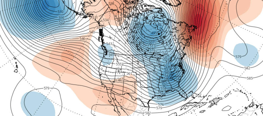
This brings me to the third and final portion of this article…the weekend snow storm potential. Let’s not get carried away here. A few models in the day 8-10 range went bonkers with this storm showing a blizzard of epic proportions. Today those models are starting to adjust towards reality. About all I am comfortable saying is that the pattern supports a larger snow storm than what we just saw. There is a winter storm signal. I say this because we know there’s going to be at least a weak ridge in the W US, a deep trough in the E US and blocking near Greenland.
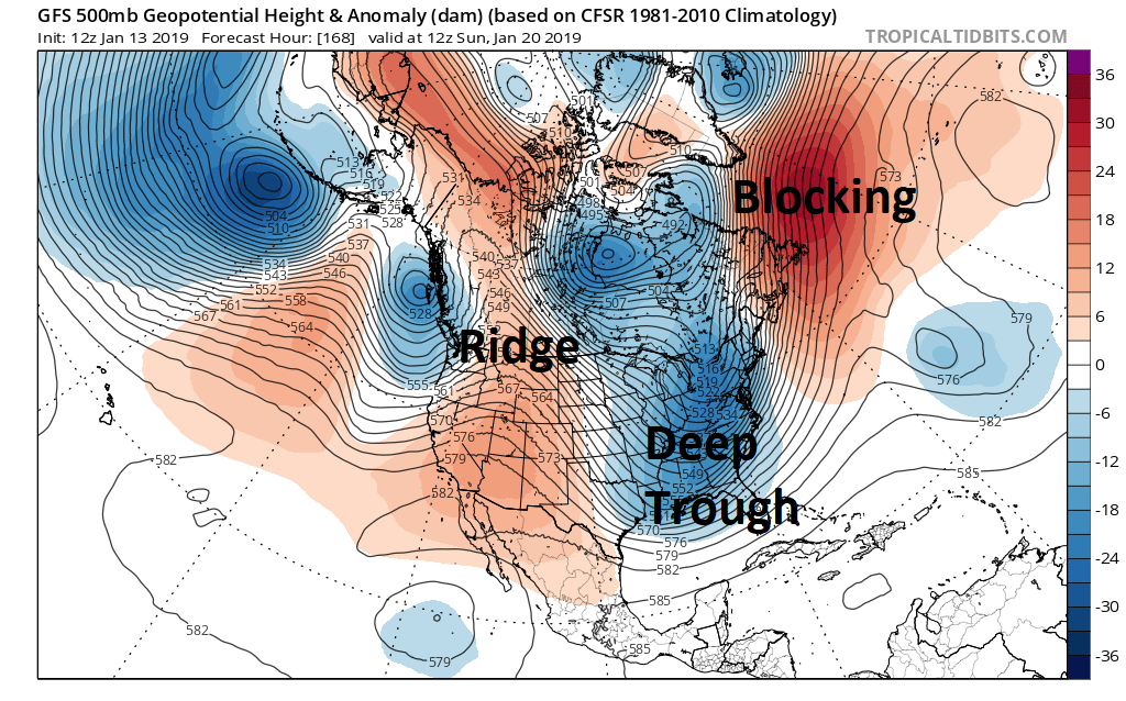
The W US ridge is not as strong as I would like to see and the blocking near Greenland is a little E of where I’d like to see it. But overall, there’s adequate upper-level support to argue a favorable winter storm signal for the Mid-Atlantic and NorthEast US. I do see the potential for warm layer marine involvement that could keep areas along and SE of I-95 possibly in a rainy icy mix rather than all pure snow. Such a situation would mean NWNJ (NW of I-95/NJTP) seeing the snowiest impact. Such a scenario is completely plausible if the W US ridge is too weak and therefore flattens out the meridional amplitude of the jet stream. If the low can stay far enough offshore of SENJ then most of NJ would be in business for a significant-to-major storm system. These are the kind of details that we simply won’t know until later this week.
The detailed specifics at the surface are just too difficult to iron out from this point. From now until about Tuesday/Wednesday I’m just going to continue tracking the strong winter storm signal mostly from the upper-levels via ensemble guidance and live global observations. If we get to Wednesday and the signal is still screaming then it will be time to track seriously with detailed snow maps, possibly a video or two, heading into the weekend. For now please try not to get caught up in the hype and worry. There is very strong uncertainty from this range. What we are confident in however is the flip to an overall active winter pattern. One that should close out the rest of January and last well into February.
In English: Snowfall is about finished for all areas of NJ. One or two more snow bands in SNJ and then all areas taper off to colder clearing skies by midnight tonight. I wouldn’t be surprised to see scattered snow showers move through SNJ this evening. This could throw fresh trace accumulations down on top of existing snowpack. Monday-Thursday looks fairly uneventful (dry and cold) with highs near-40 and lows in the 20s for most. Friday-Saturday might feature short-lived milder temperatures before another winter storm possibility later in the weekend. There’s a winter storm signal showing but it is simply too soon for expected accumulation amounts, precipitation types, exact timing, etc. I’ll be posting daily this week about it and might even dust off the video-making equipment. There is no reason to panic or hype from this range. Serious tracking will begin on Tuesday or Wednesday if the larger winter storm signal is still screaming. 10,000 people have now downloaded the free Weather NJ mobile app on Apple and/or Android. Have a great rest of your Sunday and please be safe! JC
Jonathan Carr (JC) is the founder and sole operator of Weather NJ, New Jersey’s largest independent weather reporting agency. Since 2010, Jonathan has provided weather safety discussion and forecasting services for New Jersey and surrounding areas through the web and social media. Originally branded as Severe NJ Weather (before 2014), Weather NJ is proud to bring you accurate and responsible forecast discussion ahead of high-stakes weather scenarios that impact this great garden state of ours. All Weather. All New Jersey.™ Be safe! JC


LOCAL FORECAST | INTERACTIVE RADAR | LATEST NJ WEATHER ALERTS | WEDDING FORECAST| PRIVACY POLICY
© Copyright 2026 Weather NJ LLC. All Rights Reserved.
Some information that can be found on our website is provided by a private weather station and is not an officially recognized station for weather reporting. Though we always strive to achieve accurate reporting for our own use, it is important that you do NOT depend on the data provided here for any purpose.
