

Thunderstorm Outbreak Expected Tonight
Discussion: Today should be the stormiest day of this entire rainy and stormy stretch. Much of today will be spent in a warm sector with S flow ahead of a storm front. Isolated-to-scattered storm cells are possible today before the main event tonight. They would likely be isolated-to-scattered and very hit or miss.
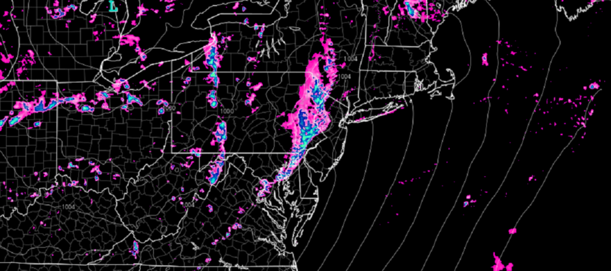
The main storm front should then pass through later tonight. I will try my best to update timing later today. But as of right now, the storm front should knock on WNJ’s door around 7pm, push across NJ from W to E between about 8-10pm then clear ENJ completely by 11PM. The actual period of storms and downpours will likely only be a 30-60 minute event that pushes through your area between that general 7-11pm window. Again, WNJ first and ENJ last.
Standard thunderstorm concerns are in place today and are the most probable outcome. This includes periods of heavy rainfall, capable of producing flash flooding, and gusty winds. There are also more severe, but less probable concerns, such as severe winds, hail, and an isolated tornado or two.
Today’s storm front will be mainly from linear frontal energy attached to a low over the Great Lakes. Once the storm front pushes through by midnight tonight, it should then usher in a less humid/more comfortable air mass into NJ for Tuesday through Thursday/Friday. Then by the weekend we should return to heat and humidity.
In English: Expect a cloudy and stormy day for the most part. Storms should just be isolated during the day but then a main event storm front should push through NJ from about 7pm to 11pm from W to E. Heavy rain, gusty winds, and lightning are likely for most areas. Severe winds, hail, and a tornado or two are less likely/more isolated but definitely on the table as a non-zero chance. Tonight is one of those nights you’ll want to have candles/flashlights ready if you lose power. You’ll also want to pay attention to any NWS warnings for severe thunderstorms or tornadoes. I’ll put a weekly outlook out tomorrow for the rest of the week. For now, the concern is focused on tonight’s storm front. Be safe! JC
Premium Services
KABOOM Club offers inside info forecast discussion, your questions answered, and early storm impact maps (ahead of the public). At 99 cents per month, it’s an extremely feasible way to show support.
My Pocket Meteorologist (MPM), in partnership with EPAWA Weather Consulting, offers professional/commercial interests, whose businesses depend on outdoor weather conditions (snow plowing, landscaping, construction, etc.), with hyper-local text message alerts/forecasts and access to the MPM premium forum—the most comprehensive and technical forecast discussion available for PA and NJ.
Jonathan Carr (JC) is the founder and sole operator of Weather NJ, New Jersey’s largest independent weather reporting agency. Since 2010, Jonathan has provided weather safety discussion and forecasting services for New Jersey and surrounding areas through the web and social media. Originally branded as Severe NJ Weather (before 2014), Weather NJ is proud to bring you accurate and responsible forecast discussion ahead of high-stakes weather scenarios that impact this great garden state of ours. All Weather. All New Jersey.™ Be safe! JC


LOCAL FORECAST | INTERACTIVE RADAR | LATEST NJ WEATHER ALERTS | WEDDING FORECAST| PRIVACY POLICY
© Copyright 2026 Weather NJ LLC. All Rights Reserved.
Some information that can be found on our website is provided by a private weather station and is not an officially recognized station for weather reporting. Though we always strive to achieve accurate reporting for our own use, it is important that you do NOT depend on the data provided here for any purpose.
