


Thunderstorm Update

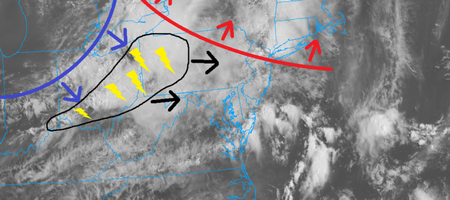
Discussion: The image above illustrates my best approximation of the warm front (red), cold front (blue) and today’s main cluster of thunderstorms (black).
The warm front is almost through NJ (moving SW to NE). It just sparked a cell for NENJ that is currently moving out. Notice how soupy is feels on the other side of the warm front. Dew point temperatures went from 50s to 70s in less than 12 hours for most of NJ. This warm front has its own lifting (hops over the cold air in front of it) and that lifting is what was enough for the NENJ cell. Some other lighter showers occurred along the warm front this morning but we’re now onto the next stage, inside of the warm sector.
The warm sector is the area between the cold front and warm front. It’s called the warm sector because it hurls in warmer temperatures and higher humidity from the S (Gulf air). Everything rotates around the low (Currently off the map up in Canada) including the frontal boundaries, warm sector, cold front, etc. as part of the Norwegian Cyclone Model. Inside this warm sector will be where the strongest thunderstorms should occur. It will be some time before that black area of thunderstorms of interest gets to NJ. They might not arrive in WNJ until 4-5pm today and could take until 10-11pm to clear ENJ. Therefore at least slow drenching thunderstorms with frequent lightning is a solid expectation for today. The more damaging potential aspects of these storms (straight-line gusty winds and/or isolated tornado) is still yet to be determined. But this will be heavily influenced by a few factors: How much sun reaches the ground in the warm sector (suns out guns out or cloud debris prevents such). How much the current isolated pop-up thunderstorms stabilize the atmosphere for the main event later. How much the upper jet vents, strengthens and maintains thunderstorm intensity. How much of a capping inversion forms in the low-mid levels.
So far, it’s rather cloudy across NJ. We need to see how much sun reaches the surface, through the clouds, between about noon and 4-5pm when the main cluster of storms approaches. If it stays cloudy then there’s a better chance for most to see just downpours, lightning and run-of-mill thunderstorm wind gusts. If the sun comes out and stays out for a few hours, then it will heat the surface and destabilize the lower atmosphere which would support a more damaging wind outcome.
The cold front is still pretty far back to the NW. When we get to about 10-11pm tonight, the warm front will be well through and we’ll be approaching the end of the warm sector being over NJ. The warm sector storms (pre-frontal activity) will be pushing offshore. We’ll then turn to any showers/thunderstorms, riding the immediate cold front, to slowly push through (slow cold front) between late tonight and tomorrow. It might be 5-6pm Wednesday before that fully happens with pop-ups possible anytime before on Wednesday.
The immaculate weather conditions coming after the cold front (Thursday through the weekend) are still in play.
In English: A few showers and thunderstorms have come through this morning with the warm front. We’re now in a lull where thunderstorm activity should be isolated. At about 4-5pm the main batch of thunderstorms should approach WNJ and push through NJ from W to E until about 10-11pm. There’s no way to pinpoint to the hour or specific county/town but that general time range is a good starting point for timing and all of NJ is on the hook for the possibility. If this lull stays cloudy then the storms later should be weaker. If the sun comes out and stays out for a few hours during the lull (between now and 4-5pm) then the storms could feature damaging wind aspects (straight-line wind gusts > 50mph and/or isolated tornadoes). Regardless, I think most of NJ is on the hook for periods of frequent lightning and downpours capable of producing flash flooding. The wind damage element is still unknown. Prepare for the worst. Hope for the best. Radar obs posts to come. Be safe! JC
Premium Services
KABOOM Club offers an ad-free environment, inside info (Above and Beyond) forecast discussion, your questions prioritized, and early storm impact maps and video releases (ahead of the public). At $1.99 per month, it’s an extremely feasible way to show additional support for Weather NJ and you can turn it on and off for however many months you wish. Think of it as a tip jar with perks. Available onFacebook or Patreon.
My Pocket Meteorologist (MPM), in partnership with EPAWA Weather Consulting, offers professional/commercial interests, whose businesses depend on outdoor weather conditions (snow plowing, landscaping, construction, etc.), with hyper-local text message alerts/forecasts from real meteorologists and access to the MPM premium forum—the most comprehensive and technical forecast discussion available for PA and NJ commercial interests.
KABOOM Shop is live if you want some KABOOM or Weather NJ Merch!

Jonathan Carr (JC) is the founder and sole operator of Weather NJ, New Jersey’s largest independent weather reporting agency. Since 2010, Jonathan has provided weather safety discussion and forecasting services for New Jersey and surrounding areas through the web and social media. Originally branded as Severe NJ Weather (before 2014), Weather NJ is proud to bring you accurate and responsible forecast discussion ahead of high-stakes weather scenarios that impact this great garden state of ours. All Weather. All New Jersey.™ Be safe! JC



LOCAL FORECAST | INTERACTIVE RADAR | LATEST NJ WEATHER ALERTS | WEDDING FORECAST| PRIVACY POLICY
© Copyright 2026 Weather NJ LLC. All Rights Reserved.
Some information that can be found on our website is provided by a private weather station and is not an officially recognized station for weather reporting. Though we always strive to achieve accurate reporting for our own use, it is important that you do NOT depend on the data provided here for any purpose.

