

Thunderstorms Approaching
Discussion: The stormfront and cold front keep pushing forward in time. When I first started to look at this last week (See Aug 26 weekend outlook), the timing was modeled as more of a Wednesday night into Thursday morning thing. Since then, the upper-level flow has evolved more progressively (quicker) and therefore we’re now looking at the storm front arriving this evening with the cold front through by tomorrow (Wednesday) morning. The low in Canada and high over N plains are spinning a baseball pitching machine of flow towards the Mid-Atlantic US. With each of those players a few mb stronger, the faster pattern is what we get.
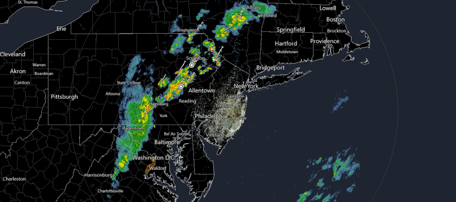
The stormfront is already moving into/through EPA now. This linear energy is more characterized as a pre-frontal leeward trough, enhanced orographically by Appalachian Mountain ramping and linear pressure decrease afterward. It’s also catching more diurnal heating this way today and therefore is already producing near-severe criteria thunderstorms for W MD through the Poconos. This stormfront should knock on New Jersey’s W border by about 7-8pm this evening (the strongest storms NJ will see) and clear ENJ by midnight tonight or just after (as a fizzling stormfront). With that said, WNJ should see stronger thunderstorms than ENJ this evening/tonight. Relief will not be immediate however as this is only the pre-frontal trough energy. Expect winds to be out of the S/SW until the stormfront pushes through…then more of a W/SW flow until the cold front arrives later Wednesday morning.
The actual cold front (lower temperatures and dew points + change of wind direction to W/NW flow) will be about 6 hours behind the pre-frontal trough’s ocean departure. Until that happens, it will likely still remain kind of warm and muggy as dews only fall into the 60s. Dews of less than 60 will hit NWNJ first (just prior to daybreak Wednesday AM) and SENJ last (by afternoon). Wednesday should feel like a slow and gradual transition towards the good feels. By Wednesday night, most should be reminded that we’re indeed getting closer to fall.
So, to recap and summarize, the stormfront moves through NJ this evening and tonight. Then the cold front moves through NJ tomorrow morning through early afternoon. Wednesday night through Saturday morning then look pleasant as heck with N winds and clear skies. Saturday still looks like the “high directly overhead” point with Sunday and Monday more humid and unsettled. As I’ve been tracking, a tropical system will likely be offshore of the east coast in the Sept 3-6 period with no current threat to NJ aside from enhanced rip currents and maybe elevated surf.
In English: Thunderstorms are approaching from the W and should enter WNJ by 7-8PM tonight. They should push through and clear ENJ by midnight or just after. Expect these storms to weaken as they cross NJ from W to E (stronger thunderstorms for WNJ – fizzling showers for ENJ). A cold front will then push through on Wednesday (also from W to E) – NWNJ first SENJ last. Then the spectacular feel should ensue from Wednesday PM well into the weekend. I’ll release a detailed full Labor Day Weekend outlook tomorrow. Have a great Tuesday night and please be safe! JC
Premium Services
KABOOM Club offers inside info forecast discussion, your questions answered, and early storm impact maps (ahead of the public). At a buck per month, it’s an extremely feasible way to show support.
My Pocket Meteorologist (MPM), in partnership with EPAWA Weather Consulting, offers professional/commercial interests, whose businesses depend on outdoor weather conditions (snow plowing, landscaping, construction, etc.), with hyper-local text message alerts/forecasts and access to the MPM premium forum—the most comprehensive and technical forecast discussion available for PA and NJ.
Jonathan Carr (JC) is the founder and sole operator of Weather NJ, New Jersey’s largest independent weather reporting agency. Since 2010, Jonathan has provided weather safety discussion and forecasting services for New Jersey and surrounding areas through the web and social media. Originally branded as Severe NJ Weather (before 2014), Weather NJ is proud to bring you accurate and responsible forecast discussion ahead of high-stakes weather scenarios that impact this great garden state of ours. All Weather. All New Jersey.™ Be safe! JC


LOCAL FORECAST | INTERACTIVE RADAR | LATEST NJ WEATHER ALERTS | WEDDING FORECAST| PRIVACY POLICY
© Copyright 2025 Weather NJ LLC. All Rights Reserved.
Some information that can be found on our website is provided by a private weather station and is not an officially recognized station for weather reporting. Though we always strive to achieve accurate reporting for our own use, it is important that you do NOT depend on the data provided here for any purpose.
