

Thunderstorms Approaching!
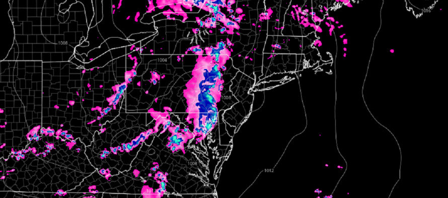
Discussion: Some AM rain pushed through this morning. We’ve been swampy since with sun and clouds…all as expected so far. Now the second stormfront is approaching NJ from the W.
Thunderstorm dynamics are far superior to the W and SW of NJ. Therefore, areas like Baltimore/DC should see stronger storms than NJ does. And given that storms will be pushing from W to E through dusk with loss of solar heating, WNJ has a chance to see stronger storms than ENJ.
Today we have diurnal instability, discernable from adequate Convective Available Potential Energy (CAPE). We have adequate wind shear and a lifting trigger of the stormfront itself. In other words, all ingredients are on the table for at least severe thunderstorms, possibly a tornado.
It’s never wise to dismiss a tornado threat. But it is important to know that tornadoes are extremely isolated events. Straight-line winds can be just as destructive when compared to the typical EF0-EF1 tornadoes we see from events like this in Jersey. I’ve seen straight-line winds flip cars on video before. Regardless of whether today’s winds end up being straight-line or tornadic, please take them seriously in the interest of safety.
It seems like these storms will knock on WNJ’s door around 7pm and clear ENJ’s coast by midnight or just after. Again, they will be pushing from W to E if you are following on radar. Once through this should set up a beautiful Tuesday-Thursday with a break from humidity and reasonable temperatures.
In English: Expect rain and thunderstorms to push through NJ tonight from W to E. They should arrive at WNJ border around 7pm and then clear ENJ coast by midnight or just after. Expect periods of heavy downpour, frequent lightning, and gusty winds. A small tornado chance is on the table and will have to be diagnosed/alerted in real-time. It is best to be inside tonight with common sense preparations in place. This includes a safe place to shelter, batteries for the flashlights, candles, etc. Prepare for the worst. Hope for the best. I’ll be posting radar analysis later this evening as the stormfront closer approaches. For now, let’s see how it goes for areas like Baltimore/DC/EPA first. Be safe! JC
Premium Services
KABOOM Club offers inside info forecast discussion, your questions answered, and early storm impact maps (ahead of the public). At 99 cents per month, it’s an extremely feasible way to show support.
My Pocket Meteorologist (MPM), in partnership with EPAWA Weather Consulting, offers professional/commercial interests, whose businesses depend on outdoor weather conditions (snow plowing, landscaping, construction, etc.), with hyper-local text message alerts/forecasts and access to the MPM premium forum—the most comprehensive and technical forecast discussion available for PA and NJ.
Jonathan Carr (JC) is the founder and sole operator of Weather NJ, New Jersey’s largest independent weather reporting agency. Since 2010, Jonathan has provided weather safety discussion and forecasting services for New Jersey and surrounding areas through the web and social media. Originally branded as Severe NJ Weather (before 2014), Weather NJ is proud to bring you accurate and responsible forecast discussion ahead of high-stakes weather scenarios that impact this great garden state of ours. All Weather. All New Jersey.™ Be safe! JC


LOCAL FORECAST | INTERACTIVE RADAR | LATEST NJ WEATHER ALERTS | WEDDING FORECAST| PRIVACY POLICY
© Copyright 2026 Weather NJ LLC. All Rights Reserved.
Some information that can be found on our website is provided by a private weather station and is not an officially recognized station for weather reporting. Though we always strive to achieve accurate reporting for our own use, it is important that you do NOT depend on the data provided here for any purpose.
