


Thunderstorms Approaching – A Stormy Thursday Evening

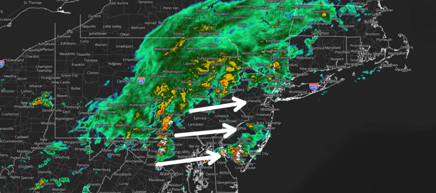
Discussion: Between now and around 8pm this evening, a disturbance will push through NJ from W to E in the form of a weak low and stormfront. Some initial action is pushing into SWNJ now (3pm) ahead of the main batch. However, the main event should occur between about 5-9pm, maybe 6-9pm.
This evening’s system is targeting all of NJ with at least some rain and rumbles. CNJ and SNJ (all of NJ S of I-78) have a better chance to see potentially damaging wind conditions than NNJ does. And SNJ (let’s call it S of I-195) is looking like ground zero for the best chance of potentially damaging wind conditions. Will everyone see damaging wind conditions or possibly large hail? No. You know how these things work by now. The most likely scenario is that only parts of NJ see the potentially damaging wind gusts while many others see just rain and rumbles.
For example: A Tornado Watch/Warning does not mean everyone and all of NJ will see a tornado. That would qualify as an apocalyptic experience and that’s not what the pros are trying to communicate. It means that the atmosphere contains physics favorable for producing a tornado which would literally impact less than 1% of NJ’s geography even if a few hit. It’s scary though, I get it. And that’s why we worry and pay attention. So, the best thing you can do is prepare for the tornado by having some safety plans and shelter locations in mind, should the uknowhat hit the fan. That way, if it happens (lower chance) you are that much better prepared. If it doesn’t happen (more likely chance)…people that’s a good thing. A tornado should never be wished for like someone wishing for a few inches of snow to close school/work/etc. A tornado is a finger of death and destruction that can easily take your rood, destroy your vehicle and possibly kill you with flying debris. That’s why we say, prepare for the worst and hope for the best. I hope everyone is with me so far.
For tonight, I expect total rainfall to fall somewhere between a half-inch and 1.5 inches for most of NJ. Like all other weather, expect isolated instances where values fall below or exceed the general range. Lightning has already proven to be frequent (the stuff entering SWNJ now – 3pm) and I expect the main event later to feature the same…more so for CNJ and SNJ. Wind can come at us in a few ways. Most likely will be straight line winds which are self-explanatory. Straight line wind gusts tend to be in the 35-50mph category for NJ’s typical garden variety thunderstorm. However, in isolated-to-scattered instances this evening, I expect straight line winds to exceed 50mph this evening which means the potential for localized wind-related power outages, broken tree limbs, rearranged loose items and outdoor furniture, downed weak trees and maybe a few shingles missing from your roof afterwards. Again, mostly straight line winds. However, because of the weak low around (wind shear amplification), we have to allow for the possibility of a tornado to form across the general CNJ/SNJ area. Obviously this has to be alerted and tracked in real-time. I expect this to clear the ENJ coast by 9pm at the latest out to sea followed by a quiet night.
In English: Thunderstorms have moved into SWNJ and are spreading into other parts of SNJ now (3pm). A larger batch of thunderstorms will then push through all of NJ between about 5-8pm from W to E. Downpours should provide most NJ areas with between a half-inch and 1.5 inches of rainfall. Lightning should be frequent. Most of NJ should see at least rain and rumbles. Some of NJ, especially CNJ/SNJ could see potentially damaging winds in the form of straight line (better chance) and or tornadic (lower chance). The focus right now is on this evening. I’ll have the weekend outlook posted tomorrow. But it does look unsettled, especially Saturday into Sunday morning. Have a great night and please be safe! JC
Radar image credit: ZoneWatch Pro
Premium Services
KABOOM Club offers an ad-free environment, inside info (Above and Beyond) forecast discussion, your questions prioritized, and early storm impact maps and video releases (ahead of the public). At $1.99 per month, it’s an extremely feasible way to show additional support for Weather NJ and you can turn it on and off for however many months you wish. Think of it as a tip jar with perks. Available onFacebook or Patreon.
My Pocket Meteorologist (MPM), in partnership with EPAWA Weather Consulting, offers professional/commercial interests, whose businesses depend on outdoor weather conditions (snow plowing, landscaping, construction, etc.), with hyper-local text message alerts/forecasts from real meteorologists and access to the MPM premium forum—the most comprehensive and technical forecast discussion available for PA and NJ commercial interests.
KABOOM Shop is live if you want some KABOOM or Weather NJ Merch!

Jonathan Carr (JC) is the founder and sole operator of Weather NJ, New Jersey’s largest independent weather reporting agency. Since 2010, Jonathan has provided weather safety discussion and forecasting services for New Jersey and surrounding areas through the web and social media. Originally branded as Severe NJ Weather (before 2014), Weather NJ is proud to bring you accurate and responsible forecast discussion ahead of high-stakes weather scenarios that impact this great garden state of ours. All Weather. All New Jersey.™ Be safe! JC



LOCAL FORECAST | INTERACTIVE RADAR | LATEST NJ WEATHER ALERTS | WEDDING FORECAST| PRIVACY POLICY
© Copyright 2026 Weather NJ LLC. All Rights Reserved.
Some information that can be found on our website is provided by a private weather station and is not an officially recognized station for weather reporting. Though we always strive to achieve accurate reporting for our own use, it is important that you do NOT depend on the data provided here for any purpose.

