

Thunderstorms Approaching for Tonight
Discussion: For the most part this week, we’re going to have an upper low gradually weakening and ultimately fading away. But before that occurs, New Jersey should see a few periods of disruption, with the first being tonight.
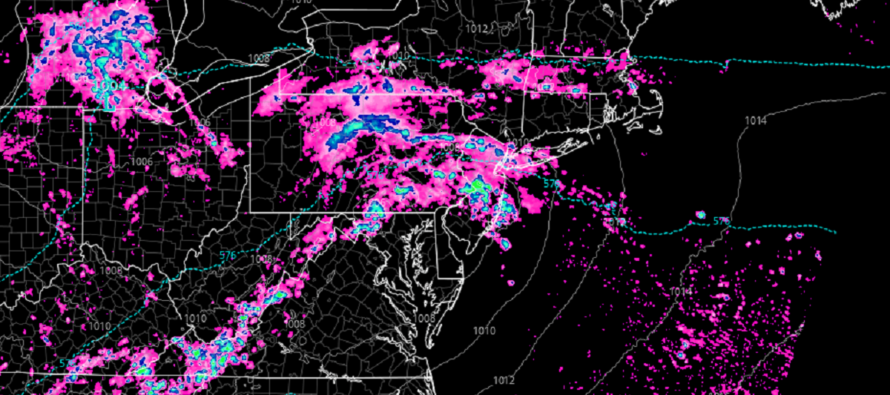
A surface area low pressure will track from the WV/WMD area across EPA/NNJ towards Cape Cod. There is adequate instability, vertical wind shear, and a lifting mechanism (the low itself) to form thunderstorms of severe potential tonight. Lightning, gusty winds, and heavy downpours are pretty much a lock. Lesser probabilities (but still possibilities) include flash flooding and isolated tornadoes.
Tonight’s thunderstorms should be knocking on WNJ’s door by 7pm. They should then track across NJ from W/SW to E/NE through just after midnight for most of NJ. NWNJ could hang on to downpours and thunderstorms later tomorrow morning, possibly through rush hour.
The rest of Tuesday looks dry until later at night closer to Wednesday AM. Another area of rain and storms could pass through as the trailing low occludes. Another rain chance Friday followed by a dry weekend under high pressure influence. That’s at least what it looks like for now. I will have a weekly outlook posted tomorrow that will cover into the weekend. For now, let’s focus on the thunderstorms tonight.
In English: Expect rain and thunderstorms to push into NJ tonight from the W/SW. Should arrive at WNJ by 7pm, push through NJ by 2-3am, and clear out for Tuesday daylight hours. NNJ could hang onto rain and storms longer than the rest of NJ overnight. But the main period I am watching is tonight between 8pm and midnight. The most likely scenario are downpours, gusty winds, and lightning. A lesser likely scenario, but still possible, includes flash flooding and isolated tornadoes. Please have a plan of shelter and safety in-place. I’ll be monitoring and posting as soon as I can see how it’s hitting and where it’s going from there. Have a great night and please be safe! JC
Premium Services
KABOOM Club offers inside info forecast discussion, your questions answered, and early storm impact maps (ahead of the public). At 99 cents per month, it’s an extremely feasible way to show support.
My Pocket Meteorologist (MPM), in partnership with EPAWA Weather Consulting, offers professional/commercial interests, whose businesses depend on outdoor weather conditions (snow plowing, landscaping, construction, etc.), with hyper-local text message alerts/forecasts and access to the MPM premium forum—the most comprehensive and technical forecast discussion available for PA and NJ.
Jonathan Carr (JC) is the founder and sole operator of Weather NJ, New Jersey’s largest independent weather reporting agency. Since 2010, Jonathan has provided weather safety discussion and forecasting services for New Jersey and surrounding areas through the web and social media. Originally branded as Severe NJ Weather (before 2014), Weather NJ is proud to bring you accurate and responsible forecast discussion ahead of high-stakes weather scenarios that impact this great garden state of ours. All Weather. All New Jersey.™ Be safe! JC


LOCAL FORECAST | INTERACTIVE RADAR | LATEST NJ WEATHER ALERTS | WEDDING FORECAST| PRIVACY POLICY
© Copyright 2026 Weather NJ LLC. All Rights Reserved.
Some information that can be found on our website is provided by a private weather station and is not an officially recognized station for weather reporting. Though we always strive to achieve accurate reporting for our own use, it is important that you do NOT depend on the data provided here for any purpose.
