

Thunderstorms Approaching New Jersey
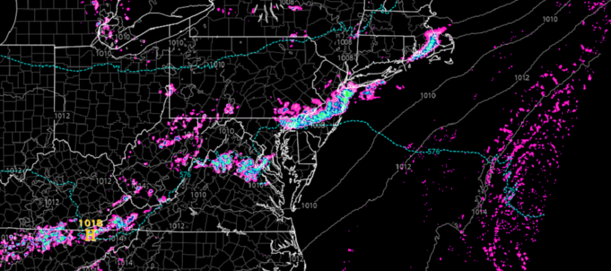
Discussion: A very progressive trough is currently aligned through SouthEast Canada and the NorthEast US. A surface low is riding the front of the trough today just to the N of Maine. A frontal boundary (cold front) is attached to that low but is also very progressive in axis (running W/SW to E/NE). Currently there is a weak area of high pressure over E Kansas with just enough front-side anticyclonic flow to push this boundary through NJ later tonight but not with authority.
With that said, the stormfront (just ahead of the cold front – more like a pre-frontal trough) should slowly advance through NJ from W/NW to E/SE (NWNJ first SENJ last) between about 4pm today and midnight tonight. The cold front should fully pass through a few hours after the storm front. The air mass behind the cold front will only feature limited relief from temperatures and humidity thanks to immediately following low pressure development offshore between Wednesday and Thursday.
Tonight’s stormfront could be a solid linear segment of storms however a broken line of storms is a more realistic expectation. With that said, some could see storms while others are missed. For those who do experience a period of thunderstorms, expect heavy downpours, gusty winds, frequent lightning, and possibly hail. Wind gusts and hail size could possibly reach severe criteria. For those who are just missed (between the storms along the stormfront), expect storm views to the NE and SW of you. But for everyone between now and when the stormfront approaches your location, expect temperatures and humidity to remain spiked with intensifying SW flow. After a hot but drier Wednesday, temperatures should then gradually fall into the weekend.
In English: Today should remain breezy out of the SW with a warm/muggy feel until a line of rain and thunderstorms push through NJ later this evening. The actual length of storm period should only be an hour or so, possibly even less. NWNJ/NNJ should see this stormfront pass through in the 3-5pm period (first). The stormfront should then make it over the I-95 corridor in the 5-8pm window (second) before finishing/fizzling out for SENJ in the 8-11pm window (last). It is very possible that the line of storms could be broken and therefore some areas miss out on the storms. However tonight looks stormy for much of NJ. Be safe! JC
Premium Services
KABOOM Club offers inside info forecast discussion, your questions answered, and early storm impact maps (ahead of the public). At a buck per month, it’s an extremely feasible way to show support.
My Pocket Meteorologist (MPM), in partnership with EPAWA Weather Consulting, offers professional/commercial interests, whose businesses depend on outdoor weather conditions (snow plowing, landscaping, construction, etc.), with hyper-local text message alerts/forecasts and access to the MPM premium forum—the most comprehensive and technical forecast discussion available for PA and NJ.
Jonathan Carr (JC) is the founder and sole operator of Weather NJ, New Jersey’s largest independent weather reporting agency. Since 2010, Jonathan has provided weather safety discussion and forecasting services for New Jersey and surrounding areas through the web and social media. Originally branded as Severe NJ Weather (before 2014), Weather NJ is proud to bring you accurate and responsible forecast discussion ahead of high-stakes weather scenarios that impact this great garden state of ours. All Weather. All New Jersey.™ Be safe! JC


LOCAL FORECAST | INTERACTIVE RADAR | LATEST NJ WEATHER ALERTS | WEDDING FORECAST| PRIVACY POLICY
© Copyright 2026 Weather NJ LLC. All Rights Reserved.
Some information that can be found on our website is provided by a private weather station and is not an officially recognized station for weather reporting. Though we always strive to achieve accurate reporting for our own use, it is important that you do NOT depend on the data provided here for any purpose.
