

Thunderstorms Approaching!
Discussion: So far this morning’s warm frontal passage has been less than impressive. I woke up to a nice downpour in Ocean County but overall, precipitation has been lighter and there haven’t been any embedded thunderstorms with the first part of today’s expectations. The warm front is doing it’s job however with elevated humidity behind it.
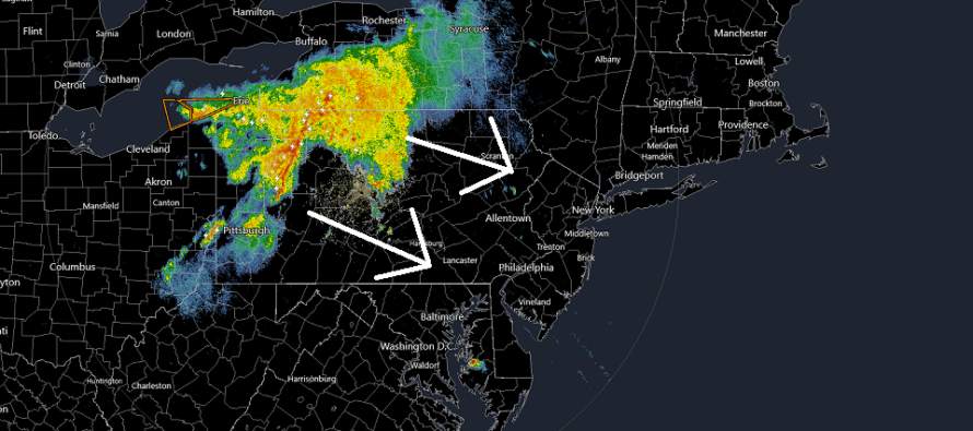
Now all eyes turn towards the Mesoscale Convective System (MCS) or Mesoscale Convective Vortex (MCV) – depending on how you look at it. Because the system closely surrounds the inner nose of a warm sector and center low, it can be viewed as more of an MCV than a MCS. But either way, it’s a system of thunderstorms with severe potential and it’s currently in NWPA heading towards New Jersey.
It looks like this next round of thunderstorms will arrive at NWNJ/WNJ as early as 3pm. It might not clear SENJ until closer to 8pm. So we’re looking at about a 5 hour period where thunderstorms will gradually shift from NWNJ through NJ and ultimately taper off over SENJ.
The sun is trying to poke through where I’m at and I imagine that’s true for other NJ locations. This could produce additional diurnal instability which could fuel thunderstorm intensity. Shear values are not impressive ahead of the MCS/MCV however are adequate over the storm area. So once it’s here, there will be adequate shear to support severe thunderstorms. Also we have the trigger of the nearby low itself.
With all of this said, I think most of NJ will experience heavy downpours with periods of frequent lightning. Some of NJ (can’t tell where exactly but you should expect it for safety) will likely see severe criteria winds, hail, and/or flash flooding. As far as damaging wind types, most MCS instances produce straight line winds rather than tornadic or circular. IMO it doesn’t matter. 70-90mph gusts are 70-90mph gusts regardless of wind direction.
As of right now, this approaching thunderstorm system is not meeting Derecho criteria. However there are at least some strong thunderstorms on the way. After this article will be real-time radar observations.
In English: Some light rain and clouds are through this morning. Now we turn to approaching thunderstorms from the W/NW. They should start in NWNJ anytime after 3pm and clear SENJ by 8-9pm. Throughout this 5-6 hour period, storms should gradually move from NWNJ to SENJ. One more reminder that once this all clears out, a gorgeous weekend is on deck. Be safe! JC
Download the free Weather NJ mobile app on Apple or Android. It’s the easiest way to never miss Weather NJ content. Our premium services go even further above and beyond at the hyper-local level.
Jonathan Carr (JC) is the founder and sole operator of Weather NJ, New Jersey’s largest independent weather reporting agency. Since 2010, Jonathan has provided weather safety discussion and forecasting services for New Jersey and surrounding areas through the web and social media. Originally branded as Severe NJ Weather (before 2014), Weather NJ is proud to bring you accurate and responsible forecast discussion ahead of high-stakes weather scenarios that impact this great garden state of ours. All Weather. All New Jersey.™ Be safe! JC


LOCAL FORECAST | INTERACTIVE RADAR | LATEST NJ WEATHER ALERTS | WEDDING FORECAST| PRIVACY POLICY
© Copyright 2026 Weather NJ LLC. All Rights Reserved.
Some information that can be found on our website is provided by a private weather station and is not an officially recognized station for weather reporting. Though we always strive to achieve accurate reporting for our own use, it is important that you do NOT depend on the data provided here for any purpose.
