

Thunderstorms Developing
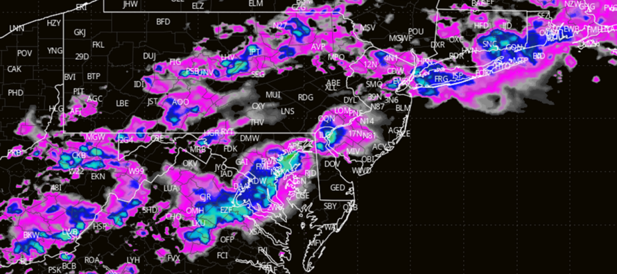
Discussion: We’ll start this week off in article mode since there is potentially damaging weather on the way. First, we have a series of weak low pressure tracking to our immediate NW (likely across NWPA from the Ohio River Valley area into the NE US/SE Canada. A warm front is attached to this low and that’s what’s currently approaching NJ from the S. The best thunderstorm dynamics (wind-producing physics) will exist right along and to the S of the warm front. Anyone N of the warm front will likely see a less stormy rainfall rather than a damaging thunderstorm breakout. So, it all depends on how far N this warm front gets today before the storms push through. The warm front is currently spanning across Delmarva and advancing towards SNJ.
Some initial precipitation should graze NNJ this afternoon with little to no thunderstorm activity outside of some embedded rumbles. Then the primary thunderstorm window is between about 4pm and 10pm for all of NJ. This is a system where the further S you are in NJ, the more intense the thunderstorm could be regarding wind gust speeds, hail, and possibly an isolated tornado. The further N you are in NJ, the better chance you have to see more of a rainier solution. CNJ could go either way but I’m currently leaning stormy. Therefore, NNJ will be less stormy/more rainy and CNJ/SNJ will be more stormy and less of a widespread rain.
We have a lot of quality ingredients on the table for more intense storms than we’ve gotten used to in the past few weeks. We have the lifting mechanism of the warm front itself, adequate wind shear values, and diurnal destabilization. These storms could sting this evening. Winds could range from “just rearranging small outdoor decorations and furniture” to “secure small human beings and expect mild-to-moderate wind damage (shingles missing, branches and trees downed, power outages, etc.)…shelter seeking storms by all means. While most winds should be straight line, we cannot rule out isolated tornadoes given the dynamics over SNJ, possibly CNJ. Rain could be heavy under active cells and produce flash flooding incidents. Hail is a lesser likely outcome but if it happens, likely pea-sized up to a half-inch in diameter. Lightning should be most frequent in SNJ and least frequent for NNJ.
Most action should clear out for a lull later tonight/overnight but isolated-to-scattered showers and thunderstorms are possible through the overnight. Tomorrow another disturbance could come through with the closely trailing but slow-moving cold front. This could bring more rain and thunderstorms to NJ between about 10am and 10pm. I will dive into that later tonight once this disturbance is through. There is uncertainty as to whether the storm activity will be more continuous tonight into tomorrow or if we will get a solid lull between.
In English: Expect a stormy late afternoon through evening tonight as thunderstorms push through with damaging wind potential, heavy rain potential, moderate-to-frequent lightning, and possibly isolated tornadoes. 4-10PM is the general window of storm potential with storms arriving first in WNJ and then clearing ENJ last. I’ll provide radar updates. Another round of storms are then possible tomorrow before we clear out for the rest of Tuesday PM through at least Thursday morning. Storms tonight could either be more of a continuous thing into tomorrow’s storm activity or there could be a lull between. This is yet TBD and will need to be decided in the 11th hour. Seeing some rain Thursday into the weekend. Not a bad thing for the drought situation but not good for outdoor interests. Have a great rest of your Monday and please be safe! JC
Premium Services
KABOOM Club offers an ad-free environment, inside info (Above and Beyond) forecast discussion, your questions prioritized, and early storm impact maps and video releases (ahead of the public). At $1.99 per month, it’s an extremely feasible way to show additional support for Weather NJ and you can turn it on and off for however many months you wish. Think of it as a tip jar with perks. Available onFacebook or Patreon.
My Pocket Meteorologist (MPM), in partnership with EPAWA Weather Consulting, offers professional/commercial interests, whose businesses depend on outdoor weather conditions (snow plowing, landscaping, construction, etc.), with hyper-local text message alerts/forecasts from real meteorologists and access to the MPM premium forum—the most comprehensive and technical forecast discussion available for PA and NJ commercial interests.
KABOOM Shop is live if you want some KABOOM or Weather NJ Merch!
Jonathan Carr (JC) is the founder and sole operator of Weather NJ, New Jersey’s largest independent weather reporting agency. Since 2010, Jonathan has provided weather safety discussion and forecasting services for New Jersey and surrounding areas through the web and social media. Originally branded as Severe NJ Weather (before 2014), Weather NJ is proud to bring you accurate and responsible forecast discussion ahead of high-stakes weather scenarios that impact this great garden state of ours. All Weather. All New Jersey.™ Be safe! JC


LOCAL FORECAST | INTERACTIVE RADAR | LATEST NJ WEATHER ALERTS | WEDDING FORECAST| PRIVACY POLICY
© Copyright 2026 Weather NJ LLC. All Rights Reserved.
Some information that can be found on our website is provided by a private weather station and is not an officially recognized station for weather reporting. Though we always strive to achieve accurate reporting for our own use, it is important that you do NOT depend on the data provided here for any purpose.
