

Thunderstorms Targeting SNJ Tonight
Discussion: As expected, today is the warmest day of the week. We have high pressure near Bermuda pumping return flow into New Jersey from the S/SW. And we have an approaching cold front attached to a low tracking through SE Canada—further reinforcing the S/SW flow in the immediate warm sector.
Some clouds will start to move in this afternoon ahead of the main event later this evening. The clouds should act as umbrellas for diurnal surface heating and could inhibit instability. Also, the storm action will be arriving during sun setting hours which could further inhibit convection. With that said, I don’t think we’re looking at an outbreak to the extent of this past Saturday. The most likely scenario tonight are your garden variety thunderstorms with some pockets capable of reaching severe criteria (SNJ/SENJ favored).
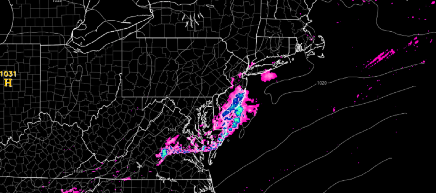
The low in Canada has occluded some which should inhibit northern areas and favor southern areas. Therefore, I am leaning away from strong thunderstorm activity in NNJ and favoring SNJ, especially extreme SNJ. Do some cells make it as far N as I-195 or even I-95? Maybe. But I think the strongest storm action will be S of I-195 with ground zero between Atlantic City and Cape May after crossing SWNJ.
I’d look to the W around 6pm-ish tonight for thunderstorms to enter WCNJ/SWNJ. They should then push across CNJ/SNJ over a few hours and clear the SENJ coast by about 10pm. Rather than a distinct stormfront, it might be more of a cluster of cells. So not just a 10-minute downpour…could be more on-and-off during that 6-10pm window.
Flash flooding and severe wind gusts are likely the primary safety hazards from this at the surface. But not all areas are guaranteed such. The most probable scenario for many are downpours and rumbles. Only some will likely experience severe conditions wherever the strongest cells set up.
In English: Expect today to remain mild and even slightly humid through late-afternoon. Clouds should move in by 5pm and then a period of rain and thunderstorms pushing through (from W to E) between about 6-10pm. We cool off behind the storms tonight for a cooler weekend. I’ll have a detailed weekend outlook out tomorrow. Let’s focus on tonight’s thunderstorms for now. Again, not like how Saturday was (tornado outbreak). More of a thunderstorm-only event with some areas reaching severe criteria for winds (SNJ/SENJ favored). Have a great rest of your Thursday. Will check in later with radar obs when storms are approaching. Be safe! JC
Premium Services
KABOOM Club offers inside info forecast discussion, your questions answered, and early storm impact maps (ahead of the public). At 99 cents per month, it’s an extremely feasible way to show support.
My Pocket Meteorologist (MPM), in partnership with EPAWA Weather Consulting, offers professional/commercial interests, whose businesses depend on outdoor weather conditions (snow plowing, landscaping, construction, etc.), with hyper-local text message alerts/forecasts and access to the MPM premium forum—the most comprehensive and technical forecast discussion available for PA and NJ.
Jonathan Carr (JC) is the founder and sole operator of Weather NJ, New Jersey’s largest independent weather reporting agency. Since 2010, Jonathan has provided weather safety discussion and forecasting services for New Jersey and surrounding areas through the web and social media. Originally branded as Severe NJ Weather (before 2014), Weather NJ is proud to bring you accurate and responsible forecast discussion ahead of high-stakes weather scenarios that impact this great garden state of ours. All Weather. All New Jersey.™ Be safe! JC


LOCAL FORECAST | INTERACTIVE RADAR | LATEST NJ WEATHER ALERTS | WEDDING FORECAST| PRIVACY POLICY
© Copyright 2026 Weather NJ LLC. All Rights Reserved.
Some information that can be found on our website is provided by a private weather station and is not an officially recognized station for weather reporting. Though we always strive to achieve accurate reporting for our own use, it is important that you do NOT depend on the data provided here for any purpose.
