

Thursday Night Stormfront
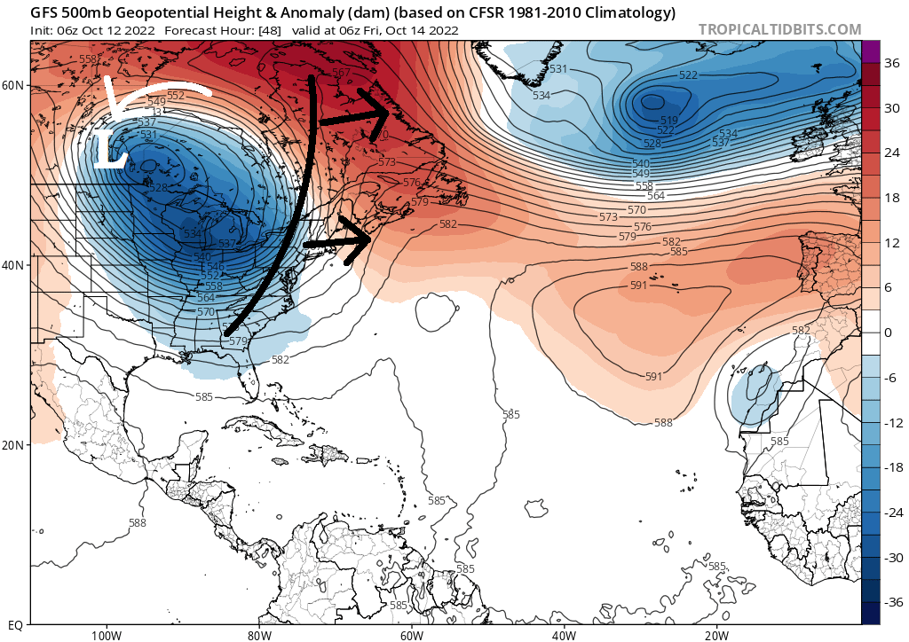
Discussion: My focus for the last few days has been on the developing Canadian ridge block that should flex, from Newfoundland to the Davis Strait area, between Thursday and Friday. This now seems a little more pronounced on the guidance data. This block should essentially trap and hold a broad upper low over Lake Superior. The surface low, that tomorrow’s cold front is attached to, would then get caught in the upper low’s NW-side steering currents and help occlude the surface low off the jet as seen below:
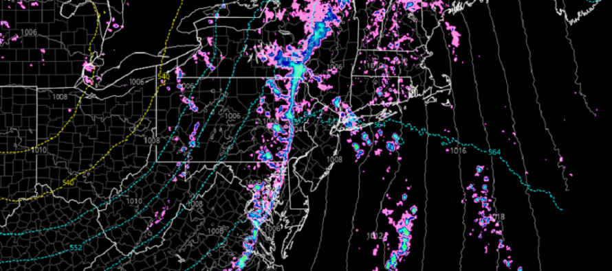
The downstream affects of this would mainly mean a later arriving stormfront (late Thursday night/early Friday morning). The frontal advancement loses some of its steam when the low occludes in Canada and it simply arrives later in New Jersey. This would mean that New Jersey spends most of Thursday in the warm sector (spiking temps, surging humidity, S winds). When the stormfront finally arrives later Thursday evening/night, it could be a very thin strip (short duration – see above cover image) of breezy/gusty downpours. This won’t be summer-like convection (relentless humidity/high CAPE) so frequent lightning is a low probability. But here and there embedded boomers are on the table. The most likely scenario for most should be a short period of breezy/gusty rain later Thursday night. It could be stronger/more severe for areas to the N and W of New Jersey where better dynamics exist. In general, stormfront intensity should range from highest to lowest (from NNJ to SNJ).
Once the front is fully through (early Friday AM), there will still be some S/SW flow around because of the Canadian occlusion. Friday and Saturday look nice and dry. However a pesky weak trailing disturbance could bring some light rain on Sunday. As of now, the rain looks mostly N and W of NJ but we shouldn’t rule out some NWNJ-clipping showers on Sunday. Behind that, a much stronger and colder cold front is expected early-to-mid next week. Not seeing any more synoptic rainmakers soon. Just mostly crisp days and chilly nights as we continue through October.
In English: Another beautiful fall day today (Wednesday). Tomorrow (Thursday) should feel warmer with temps approaching 70 and dews into the 60s by afternoon. A short period of breezy/gusty showers/downpours should then push through NJ from W to E later tomorrow night. It might be a broken line meaning some areas miss out. A few boomers could occur. By early Friday morning, everything should clear out to sea and we look good Friday and Saturday. Watching NW areas Sunday for possible light rain. Have a great rest of your Wednesday and please be safe! JC
Premium Services
KABOOM Club offers inside info forecast discussion, your questions answered, and early storm impact maps (ahead of the public). At a buck per month, it’s an extremely feasible way to show support.
My Pocket Meteorologist (MPM), in partnership with EPAWA Weather Consulting, offers professional/commercial interests, whose businesses depend on outdoor weather conditions (snow plowing, landscaping, construction, etc.), with hyper-local text message alerts/forecasts and access to the MPM premium forum—the most comprehensive and technical forecast discussion available for PA and NJ.
Jonathan Carr (JC) is the founder and sole operator of Weather NJ, New Jersey’s largest independent weather reporting agency. Since 2010, Jonathan has provided weather safety discussion and forecasting services for New Jersey and surrounding areas through the web and social media. Originally branded as Severe NJ Weather (before 2014), Weather NJ is proud to bring you accurate and responsible forecast discussion ahead of high-stakes weather scenarios that impact this great garden state of ours. All Weather. All New Jersey.™ Be safe! JC


LOCAL FORECAST | INTERACTIVE RADAR | LATEST NJ WEATHER ALERTS | WEDDING FORECAST| PRIVACY POLICY
© Copyright 2026 Weather NJ LLC. All Rights Reserved.
Some information that can be found on our website is provided by a private weather station and is not an officially recognized station for weather reporting. Though we always strive to achieve accurate reporting for our own use, it is important that you do NOT depend on the data provided here for any purpose.
