

Tracking a ~Halloween Storm Signal
Discussion: We’ve been tracking a very long-range storm signal in our premium KABOOM Club areas for a little over a week now. This was identified earlier last week given multiple data sets and a supporting pattern of oscillation status. This would be for the ~Halloween period.
No one wants to see a Halloween washout for trick-or-treating activities, including me. But now that we’re about 7 days away, it’s time to start taking the potential event a little more seriously as a synoptic storm signal. The data is still very mixed on the exact outcome expected, however most guidance now sees at least something. We are still pretty far away, too far away to look at live data observations but we can at least discuss what the model data is starting to converge on.
The current E US trough will keep us cold and dry (relative to seasonal averages) from now through most of this weekend. I’ll have the weekend outlook posted tomorrow. We should then see a small zonal flow break, of slightly positive height anomalies, from about Sunday through Monday night of next week. Next Tuesday (Oct 28) is where it starts to get interesting. Another trough is expected to develop for the E US from next Tuesday into next weekend. Let’s put this trough thought on hold to discuss the tropics.
Melissa is currently developing in the Caribbean, as late-hurricane season tropical lows typically do (no longer Cape Verde origin threats). Sandy did this if you can remember back to 2012. Melissa is expected to meander almost stationary for the next few days before departing the N Caribbean into the Atlantic around next Wed-Thurs (Oct 29-30). As of right now, most guidance keeps Melissa away from the E US coast, mainly from the steering currents coming off the bottom of the previously mentioned trough expected to set up next week. Yesterday’s Canadian model had the trough capturing Melissa into another Sandy situation but that has since lost support as a unicorn low-probability wildcard. It’s not a non-zero chance but it is very unlikely. I won’t be letting the guard down though and will pay close attention to any interaction between next week’s trough and Melissa when parallelling the east coast out to sea. Let’s assume that for now, Melissa stays out to sea.
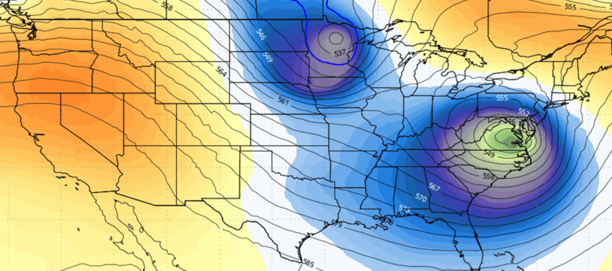
Getting back to next week’s trough, there will likely be a surface low spawned in the area of greatest positive vorticity advection (in the lower front of the trough). Today’s GFS creates this surface low and brings it through our area right in the smack middle of trick-or-treat time. The low tracks up the SE US coast and then turns inward into Virginia/W MD/W PA, throwing a slug of precipitation over NJ Oct 31. The reason it turns inland is because of the trough’s upper low digging way S into Alabama…the sfc low gets caught in the NE quadrant of the UL steering currents (SE flow).
Today’s Euro brings a less organized sfc low through our region between next Tuesday and Thursday. There is still rain with this but the rain ends by Thursday, allowing a dry Halloween. It might be a colder Halloween with NW winds, but it would be dry if the Euro verified verbatim. This is what I am hoping for however we all know the atmosphere does not respect our schedules.
Today’s Canadian holds the sfc low off until late Halloween night/Nov 1 AM. This would still allow trick-or-treating to happen but would mean a nasty coastal storm/nor’easter to affect the region with a sub-990mb low for the rest of the weekend following Halloween.
The GFS, Euro and Canadian are going to continue doing there thing. We have about a week until this happens which means we have about 4-5 days until the models converge on a most likely solution of intensity and timing.
I will be tracking this evolution closely, especially two things: 1) The interaction between next week’s trough/UL and Melissa and then 2) The sfc low that could bring rain and wind around Halloween from the trough sfc low, assuming Melissa stays out to sea. No reason to panic yet but it does look like at least some rainy/windy disruption is possible mid-to-late next week (Oct 28-31) and you should probably start developing at least a plan B should the rainier ill-timed Halloween outcome occur.
In English: I’m tracking a possible wet Halloween later next week. I am hoping that the rain either holds off until after trick-or-treat time (like the Canadian) or ends the day before (like the Euro) so the kids can have their fun. I am not hoping for a Halloween washout (like the GFS). I’ll be tracking this closely as Hurricane Melissa hopefully stays out to sea away from the trough. I’ll have a weekend outlook for this immediate weekend posted tomorrow but it looks cool and dry as of now. Have a great rest of your Thursday and please be safe! JC
Premium Services
KABOOM Club offers ad-free content, inside info forecast discussion, your questions answered, and early storm impact maps and video releases (ahead of the public). At $1.99 per month, it’s an extremely feasible way to show additional support for Weather NJ and you can turn it on and off for however many months you wish. Think of it as a tip jar with perks. Available onFacebook or Patreon.
My Pocket Meteorologist (MPM), in partnership with EPAWA Weather Consulting, offers professional/commercial interests, whose businesses depend on outdoor weather conditions (snow plowing, landscaping, construction, etc.), with hyper-local text message alerts/forecasts from real meteorologists and access to the MPM premium forum—the most comprehensive and technical forecast discussion available for PA and NJ.
Jonathan Carr (JC) is the founder and sole operator of Weather NJ, New Jersey’s largest independent weather reporting agency. Since 2010, Jonathan has provided weather safety discussion and forecasting services for New Jersey and surrounding areas through the web and social media. Originally branded as Severe NJ Weather (before 2014), Weather NJ is proud to bring you accurate and responsible forecast discussion ahead of high-stakes weather scenarios that impact this great garden state of ours. All Weather. All New Jersey.™ Be safe! JC


LOCAL FORECAST | INTERACTIVE RADAR | LATEST NJ WEATHER ALERTS | WEDDING FORECAST| PRIVACY POLICY
© Copyright 2026 Weather NJ LLC. All Rights Reserved.
Some information that can be found on our website is provided by a private weather station and is not an officially recognized station for weather reporting. Though we always strive to achieve accurate reporting for our own use, it is important that you do NOT depend on the data provided here for any purpose.
