

Tracking Ida’s Remnants for NJ
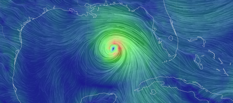
Discussion: Ida is a major hurricane (now category 3) in the middle of the Gulf of Mexico, where the water is warmest and the shear has reduced. It’s nothing but a favorable environment for further intensification, possibly into a category 4 prior to landfall. The primary steering mechanism for Ida is the ridge off the E US. This ridge should steer Ida in a gradual button hook pattern from where it is now into coastal LA between late-afternoon and evening Sunday (tomorrow).
The heavier populated E side of coastal LA (including New Orleans) is in a rough spot. Model guidance has been hugging the E side of the cone of uncertainty. The central or west coast of LA is much less populated. It’s going to hit somewhere between central and east LA IMO. Hoping it hits as far W as possible along the LA coast, removing the most destructive winds from New Orleans. This area will obviously take the most destructive winds to the face but will be isolated to the diameter of the winds surrounding the eye wall.
While the destructive winds will be isolated to the core of the hurricane, there are also widespread impacts for the entire diameter of the storm. The storm surge is going to be ugly, especially for E LA and points E of that into NW Florda. I’ve seen several estimated of 10+ feet of wind-driven storm surge. This will not couple well with the tropical heavy downpours dumping 6-12+ inches of rain on the E side of the storm system. Areas W of the eye will have winds pushing the tide out after initial swell/tide rise leading up to storm arrival.
After landfall in LA, Ida will weaken by tropical cyclone nature as it steams N likely over the Mississippi River Monday. The rainfall during this time will likely contribute to major Mississippi River flooding.
Starting Tuesday, Ida’s remnants (in the form of a mid-latitude cyclone) will traverse along/just ahead of a cold front arriving for NJ. This should be a slow moving process and allow periods of heavy rainfall to impact the Mid-Atlantic US including NJ. As of now, the heaviest axis of expected rain is modeled to fall through PA into NWNJ. There’s wiggle room in that axis between now and then. It could easily shift further NW or SE towards more of 95/NJTP. But either way, it’s a heavy rain event for us between late Tuesday night and Thursday. It does not look like a severe wind event with tornadoes and frequent lightning. Some embedded thunderstorms with their own gusty winds, sure, but not a widespread t-storm or tornado outbreak threat. Again, periods of heavy rainfall (more flash flooding) would be the mostly likely impact for us in NJ with NWNJ favored for the most rainfall.
The good news for NJ is that once this all clears out by Thursday night/overnight, it sets up a nice Labor Day Weekend starting Friday. Unfortunately it will be a while until good news comes out of coastal LA.
In English: Ida is going to hit LA tomorrow night as a major hurricane. Hopefully it will make landfall as far W as possible from the NOLA and spare the heavier populated area from the destructive winds despite coastal flooding and flash flooding being definites. Ida’s remnants will then likely dump a lot more rain for NJ, PA and general area this coming Tuesday night (late) through Thursday. Wednesday and Thursday would be the rainiest days. I’ll have the regular weekly outlook posted tomorrow. But I wanted to update you all on Ida and what she means for NJ later this week. Have a great rest of your Saturday night and please be safe! JC
Download the free Weather NJ mobile app on Apple or Android. It’s the easiest way to never miss Weather NJ content. Our premium services go even further above and beyond at the hyper-local level.
Jonathan Carr (JC) is the founder and sole operator of Weather NJ, New Jersey’s largest independent weather reporting agency. Since 2010, Jonathan has provided weather safety discussion and forecasting services for New Jersey and surrounding areas through the web and social media. Originally branded as Severe NJ Weather (before 2014), Weather NJ is proud to bring you accurate and responsible forecast discussion ahead of high-stakes weather scenarios that impact this great garden state of ours. All Weather. All New Jersey.™ Be safe! JC


LOCAL FORECAST | INTERACTIVE RADAR | LATEST NJ WEATHER ALERTS | WEDDING FORECAST| PRIVACY POLICY
© Copyright 2025 Weather NJ LLC. All Rights Reserved.
Some information that can be found on our website is provided by a private weather station and is not an officially recognized station for weather reporting. Though we always strive to achieve accurate reporting for our own use, it is important that you do NOT depend on the data provided here for any purpose.
