

Tracking Late-Weekend Snow
Discussion: Real quick, we can expect more temperature moderation today through tomorrow with dry conditions for the holiday and related travel. Should feel quite nice for this time of year. This is because of high pressure drifting through the S Mid-Atlantic US. Late Thanksgiving night into Friday morning is the expected period of frontal precipitation. Doesn’t look like anything serious, mostly a period of light-to-moderate rain only which should be out of NJ by Friday daybreak.
Friday then starts a cold period behind the front. You should notice colder temperatures again with wind chilling NW winds. Can’t rule out flurries or even a few snow showers on Friday if the Great Lake effect snow machine turns on. Such activity would likely be isolated with little-to-no accumulation. The colder NW flow should slowly rock to the W/NW by Saturday night. Still a cold source tap for Saturday but not as cold as Friday. Either way, all of NJ will be chilled down at the surface pretty good this weekend.
Sunday looks a little milder as a weak area of high pressure moves through to our S. The return flow should start a S flow that slowly rocks to an E flow once low pressure hits the ocean. Then once that low wraps up (by Sunday night), flow will resume colder out of the N for NJ ahead of a colder next week.
Let’s talk about the low pressure situation Sunday into Monday. This is the signal I’ve been tracking for a while now. It showed support in the long range but then fizzled out this past weekend. It’s now showing support again as a weaker, yet complicated, event. Sometimes energy way upstream passes over areas where there are more sensors and less sensors. Downstream surface output can therefore ghost a storm on model guidance and have it reappeared. I’ve seen stranger things happen with computers.
I’m not concerned with the surface precipitation output just yet. Some models are showing snow, some snow/rain, others still a miss. I’m more concerned with the upper-level energy setup. Energy for this event would be coming from the N stream. First the jet splits two pieces of energy, then recombines them just offshore of NJ. We therefore have two shortwaves moving in, one first on the southern split branch (1) and the other just behind it on the northern split branch (2).
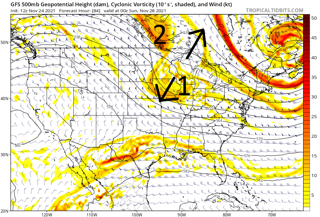
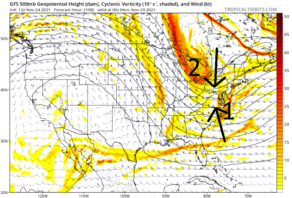
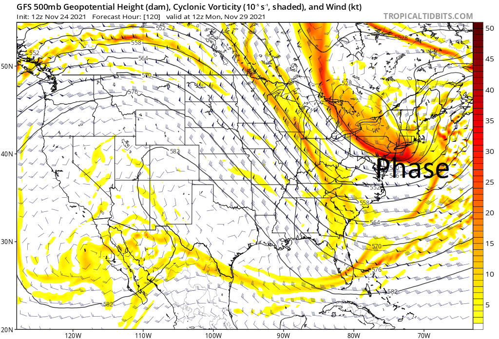
As these pieces of energy come through, first as shortwaves, they will each contain weaker precipitation below it. Once they interact, and eventually phase closer to NJ, they will produce stronger precipitation. Therefore, it will all come down to the timing and interaction of these energy pieces. Right now, the GFS is phasing later (below). The ICON is phasing earlier. The Euro is in the middle. If you want snow for all of NJ, you want to see the earliest phase possible as far S as possible.
So the signal remains for this Sunday into Monday after a very cold leading set up. We just need to watch the next few days to see how the timing of the energy pieces evolves and arrives at a more consensual solution. An earlier phase would mean getting the shovels and plows out. A later phase would mean a much less snowy solution (flurries/snow showers at most). My plan is to casually observe tomorrow (Thanksgiving) and see where things stand Friday morning. At that point it should be go or no go on our first snow event of the upcoming winter 2021-2022 season.
In English: Thanksgiving looks milder and dry. Great for parades and travel. Rain then moves through between late Thursday night and Friday morning ahead of a cold front. The cold front should usher in a cold Friday-Saturday. Sunday into Monday then depends on the upper-level energy setup described above. I am going to observe the guidance that comes in through Thanksgiving Day. I might provide some commentary on social media but plan to write a go or no-go snow event article Friday morning depending on what the model guidance and live observations are suggesting. Right now, it looks like a 1-3″ (for most)/3-6″ (jackpot) type snow event is still on the table for Sunday night into Monday with NWNJ favored for more snow than SENJ. Everyone have a great Thanksgiving and please be safe! JC
Download the free Weather NJ mobile app on Apple or Android. It’s the easiest way to never miss Weather NJ content. Our premium services go even further above and beyond at the hyper-local level.
Jonathan Carr (JC) is the founder and sole operator of Weather NJ, New Jersey’s largest independent weather reporting agency. Since 2010, Jonathan has provided weather safety discussion and forecasting services for New Jersey and surrounding areas through the web and social media. Originally branded as Severe NJ Weather (before 2014), Weather NJ is proud to bring you accurate and responsible forecast discussion ahead of high-stakes weather scenarios that impact this great garden state of ours. All Weather. All New Jersey.™ Be safe! JC


LOCAL FORECAST | INTERACTIVE RADAR | LATEST NJ WEATHER ALERTS | WEDDING FORECAST| PRIVACY POLICY
© Copyright 2026 Weather NJ LLC. All Rights Reserved.
Some information that can be found on our website is provided by a private weather station and is not an officially recognized station for weather reporting. Though we always strive to achieve accurate reporting for our own use, it is important that you do NOT depend on the data provided here for any purpose.
