

Tracking Saturday’s Rain
Discussion: A very progressive trough will swing through the NorthEast US this weekend. At the same time, a disturbance will eject off the top of the C US ridge and track along a boundary through the S Mid-Atlantic US on Saturday. This disturbance was originally modeled further to the S, earlier this week, however the trough/ridge orientation has changed for a track further to the N—bringing rain to at least parts of SNJ. The latitude of the boundary (from ~N Plains through ~Delmarva) will determine the northern extend of precipitation and thunderstorms. Therefore, we have a few scenarios that could play out Saturday based on the exact track of the low:
- N track – NNJ sees rain, CNJ/SNJ sees heavy rain and storms.
- Middle track – NNJ stays mostly dry. CNJ sees rain. SNJ sees heavy rain and storms.
- S track – NNJ and CNJ stay mostly dry. SNJ is scraped by rain, possibly storms.
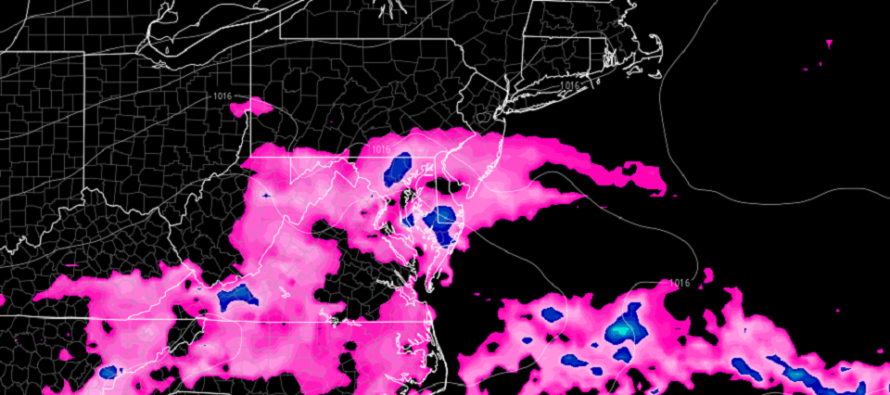
With that said, NNJ has the best chance to stay dry and SNJ has the best chance to see rain and thunderstorms. I’m currently leaning towards something between the middle track (#2) and the S track (#3). The above image shows the NAM’s northern extent of rain. This might be a little too far N but represents the general mean of data spread. The GFS and Euro are further N but the shorter-range mesoscale models are further S. The high-res NAM barely even scrapes Cape May/Cumberland/Atlantic Counties. With that said, the N track option (#1) is becoming less likely per the latest data. Most models are keeping the rain S of I-195. Conditions should then clear out completely between Saturday afternoon and evening hours as high pressure moves in and provides statewide goodness (clear, sunny, low humidity, highs near-80, lows in lower-60s) from Saturday night through all of Sunday and Monday. On Tuesday, the high will be offshore and will provide a more humid return flow (winds out of the S/SW)
Friday (July 8) high temperatures should reach into the low-to-mid 80s for most, maybe closer to 90 away from the ocean. Skies should be mixed with sun and clouds with a humid feel. Showers and thunderstorms are possible for afternoon-evening hours but more hit-or-miss. Winds should be light out of the SW. Overnight lows should fall into the 65-70 range statewide as rain/storm chances persist into Saturday morning.
Saturday (July 9) high temperatures should stay just under 80 for most areas. Conditions should range in NJ from N to S. NNJ has the best chance to stay dry. CNJ has the next best chance to stay dry (cannot take rain off the table especially closer to SNJ). SNJ has the best chance to see at least some rain, possibly thunderstorms. The further S you are the better the rain chance. For example, Cape May looks rainier than the Philly<—>Toms River latitude. Winds should be light out of the E/NE. Conditions should clear overnight as temps range from mid-50s to mid-60s from elevations to coasts.
Sunday (July 10) high temperatures should max out around 80 for most areas. Skies should be mostly sunny with lower humidity. Should feel pleasantly warm. Winds should be light out of the E/NE. Overnight lows should fall into the lower-60s.
An early look at next week indicates the lower humidity/clear conditions spilling through Monday maybe into some of Tuesday. The rest of next week looks pretty run-of-mill for July…temps in the 80s/90s, higher humidity, sunny during most of the day, afternoon/evening pop-ups, etc. Lets take a closer look on Sunday night. Have a great weekend and please be safe! JC
Premium Services
KABOOM Club offers inside info forecast discussion, your questions answered, and early storm impact maps (ahead of the public). At a buck per month, it’s an extremely feasible way to show support.
My Pocket Meteorologist (MPM), in partnership with EPAWA Weather Consulting, offers professional/commercial interests, whose businesses depend on outdoor weather conditions (snow plowing, landscaping, construction, etc.), with hyper-local text message alerts/forecasts and access to the MPM premium forum—the most comprehensive and technical forecast discussion available for PA and NJ.
Jonathan Carr (JC) is the founder and sole operator of Weather NJ, New Jersey’s largest independent weather reporting agency. Since 2010, Jonathan has provided weather safety discussion and forecasting services for New Jersey and surrounding areas through the web and social media. Originally branded as Severe NJ Weather (before 2014), Weather NJ is proud to bring you accurate and responsible forecast discussion ahead of high-stakes weather scenarios that impact this great garden state of ours. All Weather. All New Jersey.™ Be safe! JC


LOCAL FORECAST | INTERACTIVE RADAR | LATEST NJ WEATHER ALERTS | WEDDING FORECAST| PRIVACY POLICY
© Copyright 2026 Weather NJ LLC. All Rights Reserved.
Some information that can be found on our website is provided by a private weather station and is not an officially recognized station for weather reporting. Though we always strive to achieve accurate reporting for our own use, it is important that you do NOT depend on the data provided here for any purpose.
