

Tracking the Sunday-Monday Storm Signal
Discussion: The pattern, more favorable for winter storm development, is still expected to begin this Friday. I’m still only focused on the first few systems this Friday and Sunday-Monday but a very active pattern will continue afterwards to close out January and likely start February. The Pacific Ocean has waves of energy every 3-4 days apart lined up to Asia. But again, let’s focus on what’s directly in front of us.
The Friday coastal system remains modeled just offshore. We’ll have a deepening low tracking from S to N just inside of Bermuda. On Friday, an extension of energy tries to reach the ECNJ/SENJ coast but still falls short of anything noteworthy. This would leave the ENJ surface under a slightly warmer area of drying subsidence (34-37F with clouds/flurries possible). But overall, a miss out to sea.
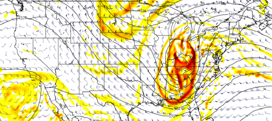
The Sunday-Monday system is taking more of a direct aim at New Jersey. There are a lot of moving parts involved (see above cover image of 500mb cyclonic vorticity). First the upper-level low (ULL) will dive in from Canada straight towards Texas. From there it will drift E through the SE US a bit. Then another area of upper-level energy will dive in after it. Where this later energy dives into will have influence over the SE US ULL and ultimately determine either a mostly wintry NJ system or a snow to rain situation. We are still too far out and there’s still too much variance. This system was targeting the Carolinas a few days ago and now targeting W PA and NY State. That’s because of so much volatility and play between the two different areas of energy. Complete chaos theory of fluid dynamics. The primary energy will be onshore (NW US/SW Canada) tomorrow morning (Thursday) and will therefore be much better sampled. The secondary will be onshore Friday morning. With that said, it’s impossible to make any kind of specific prediction or snowmap from this range. We still have 4 days (16 model suites) of data and developing live observations to narrow the scope of possibilities. Until then, let the model mayhem continue. I still believe someone on the east coast is going to get nailed with a major snowstorm in the Sunday-Monday period. I just don’t know if NJ is more frozen precipitation type or liquid type.
I’ll be paying attention to two forces that will have steering influence of the Sunday-Monday system. First is the height field over New England for early Sunday morning. If that progressive trough is deeper then it will want to take the system E. Second is the N stream trailing upper-level energy. For the snowy NJ outcome that needs to come over the Great Lakes to shove the system E rather than dig towards Arkansas and DDT the system up the interior EC.
The operational deterministic models have been suggesting the warmer interior EC solution, meaning a few inches of snow over to heavy rain for NJ. I do not buy this yet because this represents the far NW side of the ensemble mean. If the ensembles (GFS and Euro) were tightly clustering the operational deterministic I might buy it. But that is not the case which tells me we have some wild model trends likely in the next few days.
At this point I would start to expect coastal impacts regardless of precipitation type. We’re going to have some very powerful synoptic scale storm dynamics capable of producing a prolonged period of onshore flow across 1-2 high tides. Sounds like a 40-60mph wind situation (maybe higher) along immediate coastal areas with at least minor-to-moderate coastal flooding…under a full moon. I’ll be paying attention to this as well as things evolve over the next few days.
In English: Friday looks like a miss just offshore. Sunday-Monday still looks like a major storm system capable of anything from “all-snow” to “some snow to heavy rain” with high winds and a good chance of coastal problems (wind and flooding-related) I’m watching closely but it looks like something is going to happen. The pattern remains favorable for wintry storm development after Sunday-Monday likely into February. Be safe! JC
Download the free Weather NJ mobile app on Apple or Android. It’s the easiest way to never miss Weather NJ content. Our premium services go even further above and beyond at the hyper-local level.
Jonathan Carr (JC) is the founder and sole operator of Weather NJ, New Jersey’s largest independent weather reporting agency. Since 2010, Jonathan has provided weather safety discussion and forecasting services for New Jersey and surrounding areas through the web and social media. Originally branded as Severe NJ Weather (before 2014), Weather NJ is proud to bring you accurate and responsible forecast discussion ahead of high-stakes weather scenarios that impact this great garden state of ours. All Weather. All New Jersey.™ Be safe! JC


LOCAL FORECAST | INTERACTIVE RADAR | LATEST NJ WEATHER ALERTS | WEDDING FORECAST| PRIVACY POLICY
© Copyright 2026 Weather NJ LLC. All Rights Reserved.
Some information that can be found on our website is provided by a private weather station and is not an officially recognized station for weather reporting. Though we always strive to achieve accurate reporting for our own use, it is important that you do NOT depend on the data provided here for any purpose.
