

Tracking Thunderstorms

Discussion: The rest of today (Tuesday) should remain nice however tomorrow (Wednesday) and Thursday are being targeted by showers and thunderstorms. I don’t think we’re looking at a severe outbreak but at least a “it’s warm season thunderstorm time” feel to it. Let’s start with the National Weather Service’s Storm Prediction Center’s projection:
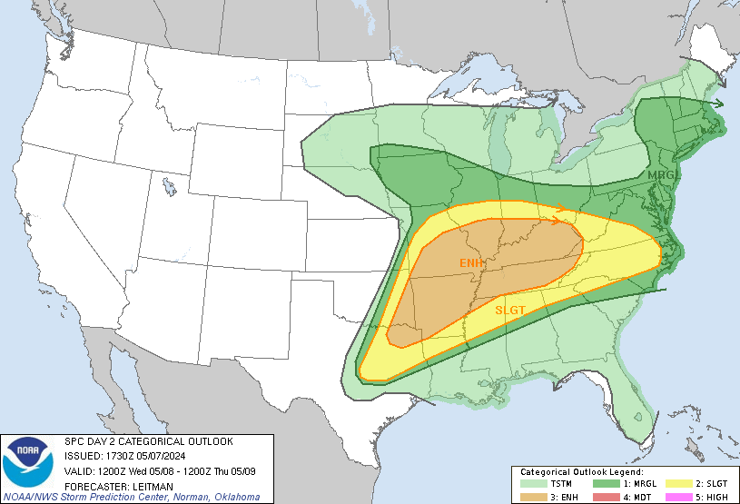
Wednesday
Thursday
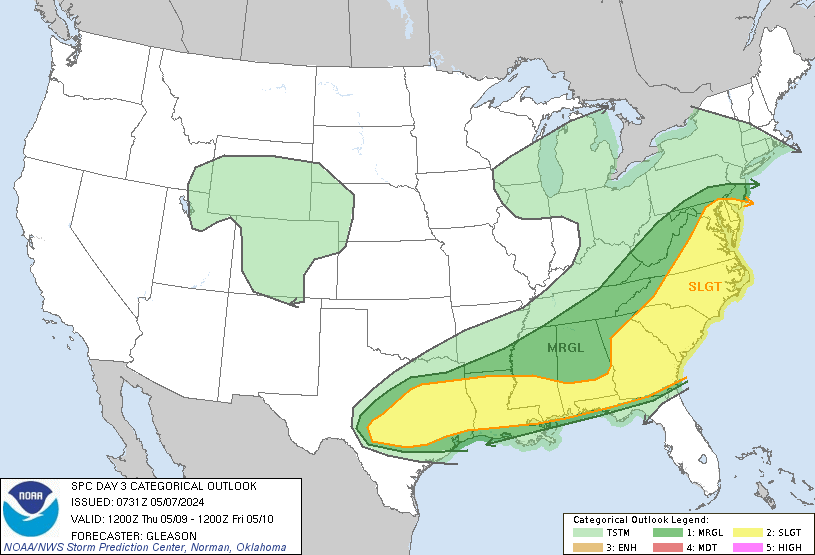
As you can see, New Jersey is in the Marginal (MRGL) category for tomorrow (Wednesday) and then SNJ is into the Slight (SLGT) category on Thursday with NNJ/CNJ in the lower categories. This is concurrent with the model data in the sense that Wednesday is more of a NNJ/CNJ concentration of thunderstorm potential and Thursday is more favored for SNJ to see thunderstorms.
Again, I do not see a severe outbreak. We absolutely cannot rule out isolated instances of severe criteria being met for wind gust speed and/or hail. We also cannot rule out the potential for an isolated tornado situation despite being a low probability. This time of year, you have cold air aloft with warmer surface air and that is generally a better environment for tornado development than an all warm layer environment that typically caps storms out. We’re not dealing with a ton of instability for either day (Wednesday or Thursday) however we do have adequate wind shear. So, my best gut feel are showers and strong boomers for all of NJ as a general expectation while allowing for isolated cells to become severe at times.
Timing is still very uncertain. Most short-range model guidance has a first round late tomorrow (Wednesday) morning (more certain) with a second round towards tomorrow evening (less certain). Wednesday’s storms should approach from the W/NW and push through NJ to the E/SE. Thursday then seems like a late-morning into early-afternoon window for the storms to push through NJ from W/SW to E/NE.
The rest of the week should shake out as described in yesterday’s weekly outlook. Warmer temps with showers and thunderstorms possible any day/time. Tomorrow (Wednesday) and Thursday however seem to feature the best chances for thunderstorms to occur.
In English: This week will remain mild and unsettled. Tomorrow (Wednesday) and Thursday seem to feature the best chances of the week for thunderstorms to impact NJ. Looks like at least showers/downpours with a few rumbles but could escalate to at least a few isolated instances of severe thunderstorm cells. While a low probability, you can never rule out an isolated tornado with this kind of setup. That will have to be determined in real-time but again, low probability. Wednesday looks like two possible rounds…at least Wednesday late morning but possibly also Wednesday afternoon/evening. Thursday looks like late-morning into early afternoon. This situation does not look extremely hazardous or anything. But having backup plans would likely help. I’ll have the weekend outlook posted Thursday. Have a great rest of your Tuesday and please be safe! JC
Premium Services
KABOOM Club offers inside info forecast discussion, your questions answered, and early storm impact maps (ahead of the public). At a buck per month, it’s an extremely feasible way to show support.
My Pocket Meteorologist (MPM), in partnership with EPAWA Weather Consulting, offers professional/commercial interests, whose businesses depend on outdoor weather conditions (snow plowing, landscaping, construction, etc.), with hyper-local text message alerts/forecasts and access to the MPM premium forum—the most comprehensive and technical forecast discussion available for PA and NJ.
Get your KABOOM Inside Out pajamas and more at the KABOOM shop!
Jonathan Carr (JC) is the founder and sole operator of Weather NJ, New Jersey’s largest independent weather reporting agency. Since 2010, Jonathan has provided weather safety discussion and forecasting services for New Jersey and surrounding areas through the web and social media. Originally branded as Severe NJ Weather (before 2014), Weather NJ is proud to bring you accurate and responsible forecast discussion ahead of high-stakes weather scenarios that impact this great garden state of ours. All Weather. All New Jersey.™ Be safe! JC


LOCAL FORECAST | INTERACTIVE RADAR | LATEST NJ WEATHER ALERTS | WEDDING FORECAST| PRIVACY POLICY
© Copyright 2025 Weather NJ LLC. All Rights Reserved.
Some information that can be found on our website is provided by a private weather station and is not an officially recognized station for weather reporting. Though we always strive to achieve accurate reporting for our own use, it is important that you do NOT depend on the data provided here for any purpose.
