

Transitional Conditions Expected
Discussion: I had a feeling the tropics were going to heat up when we were on vacation. But we’re back and normal updates will now resume. Our 4-year-old daughter had the time of her life in Disney World. Our first family vacation since she was born. Anyway… I know there are a lot of travel-related weather interests this next week before students and teachers return to school, etc. so I will cover NJ first then discuss some of that later.
For NJ, the upper pattern is straightforward. A trough will swing through this week providing an unsettled period mid-week (~Wednesday) followed by excellent weather conditions Thursday into the weekend. The Wednesday rain, and possibly storms, will clear out the humidity as well. Today and tomorrow, however, will remain humid but not hot…comfortably sticky. Ultimately high pressure will both keep the tropical cyclones away and provide the nicer weather later in the week.
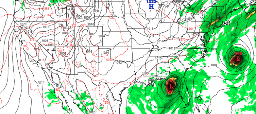
For areas S and E of NJ, there are two tropical cyclones of interest, Franklin and Idalia. Major Hurricane Franklin is currently between the Bahamas and Bermuda and will stay offshore of the east coast as it tracks between NJ and Bermuda (closer to Bermuda) this Tues-Wed. The only impacts most of the east coast will see from Franklin are rip currents and elevated swell/surf Tues-Thurs. No rain or wind as it is too far away. Tidal levels possibly up a bit but nothing serious. Idalia, on the other hand, is expected to make direct landfall in W Florida somewhere between Panama City and Tampa (likely somewhere near the Big Bend area). Idalia could strike this area as a major hurricane this Wednesday morning. It should then track across N FL over coastal GA/SC/NC as it recurves back into the Atlantic Ocean just S of OBX Thursday (S of NJ with little-to-no NJ impact). The high pressure I mentioned above should be centered near NJ at that time and should force it that way. I’m seeing a lot of tropical forcing in the SE US/Bahamas area next week so I wouldn’t be surprised to see more activity once we get through Franklin and Idalia.
Basically, the two tropical cyclones are going to miss NJ but pull in some very pleasant air for NJ as they pull away.
Monday (Aug 28) high temperatures are mostly hovering in the 70s today with elevated humidity. A few interior CNJ/SNJ spots have just broken 80. Skies are mixed with more sun than clouds and winds are light out of the E. Overnight lows should range from 60-70 from NNJ elevations to SNJ coasts with isolated showers and boomers possible through early Tuesday morning.
Tuesday (Aug 29) high temperatures should reach the mid-to-upper 70s for most NJ locations. Skies should be mostly cloudy with a humid feel. Isolated-to-scattered showers and boomers are possible. Winds should be light out of the NE. Overnight lows should fall into the 65-70 range for most NJ locations. Beachgoers should practice safety regarding coastal rip currents and enhanced surf from Hurricane Franklin (way out to sea).
Wednesday (Aug 30) high temperatures should reach the low-to-mid 80s for most NJ locations. Skies should start cloudy with a few showers around, maybe even rumbles, but improve (breaking sun and lowering humidity) through afternoon hours. Nighttime should feel like a different season than morning. Winds should be light out of the W/NW. Overnight lows should range from 55-65 from NNJ elevations to SNJ coasts. There might be some enhanced surf and rip currents along the coast, but this should subside by evening hours. Again, use caution if the beach flags say to.
Thursday (Aug 31) high temperatures should reach the mid-70s for most NJ locations. Skies should be mostly sunny with a pleasant feel. Winds should be light-to-breezy out of the N/NE. Overnight lows should range from 50-60 from NNJ elevations to SNJ coasts.
Friday (Sept 1) high temperatures should reach the 75-80 range for most NJ locations. Skies should be mostly sunny. Winds should be light out of the E/NE. Overnight lows should fall to the 55-65 range from NNJ elevations to SNJ coasts.
An early look at Labor Day Weekend indicates fair conditions. Highs in the 78-85 range with mostly clear skies to start the weekend. Some clouds and returning humidity by the end of the weekend but mostly dry. Let’s have another look in a few days. Have a great week and please be safe! JC
Premium Services
KABOOM Club offers inside info forecast discussion, your questions answered, and early storm impact maps (ahead of the public). At a buck per month, it’s an extremely feasible way to show support.
My Pocket Meteorologist (MPM), in partnership with EPAWA Weather Consulting, offers professional/commercial interests, whose businesses depend on outdoor weather conditions (snow plowing, landscaping, construction, etc.), with hyper-local text message alerts/forecasts and access to the MPM premium forum—the most comprehensive and technical forecast discussion available for PA and NJ.
Jonathan Carr (JC) is the founder and sole operator of Weather NJ, New Jersey’s largest independent weather reporting agency. Since 2010, Jonathan has provided weather safety discussion and forecasting services for New Jersey and surrounding areas through the web and social media. Originally branded as Severe NJ Weather (before 2014), Weather NJ is proud to bring you accurate and responsible forecast discussion ahead of high-stakes weather scenarios that impact this great garden state of ours. All Weather. All New Jersey.™ Be safe! JC


LOCAL FORECAST | INTERACTIVE RADAR | LATEST NJ WEATHER ALERTS | WEDDING FORECAST| PRIVACY POLICY
© Copyright 2026 Weather NJ LLC. All Rights Reserved.
Some information that can be found on our website is provided by a private weather station and is not an officially recognized station for weather reporting. Though we always strive to achieve accurate reporting for our own use, it is important that you do NOT depend on the data provided here for any purpose.
