

Tropics Finally Awaken
Discussion: For the immediate future we’ll generally stay warm, humid, and slightly unsettled through about Wednesday of next week. Model consensus has consistently suggested a break in the pattern starting next Thursday which would produce stellar conditions for Labor Day weekend. We’d likely see a high pressure-reinforced cold front next Wednesday night/early Thursday morning which could feature a stormfront. But then high pressure would have control with dry sinking air for Thursday through at least Monday. We still need to get through this weekend (outlook out tomorrow) but that’s the general idea for the next few weeks.
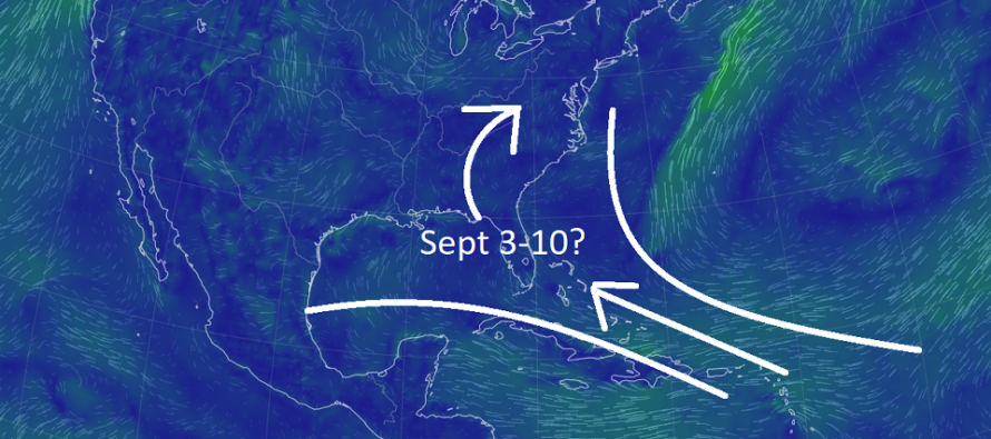
Labor Day Weekend then starts a period where long-range model guidance is suggesting tropical activity either in the Gulf of Mexico or Bahamas region to begin. We’re pretty far out from that period but it looks like at least something will form and pass through that way, possibly into the N Gulf states and ultimately cycling around as remnants for New Jersey a few days later (see above cover graphic).
Tropical remnants can pack a punch in New Jersey as we’ve learned in the last few years. There’s always a funky energy with such that can lead to tornadoes and flash-flooding downpours. Ida and Else were examples of recent times. We won’t however know exactly what this will be until we’re locked on a Gulf or Bahamas/Caribbean tropical storm system.
So, the general September 3-10 period is looking like when the tropics will finally wake up this year. So far, almost every Cape Verde origin system has encountered suppression from eastern/central Atlantic high pressure/ridge (squashes system towards equator), Sahara Desert dust (dries environment), or high wind shear (decouples tropical organization). It looks like that Sept 3-10 window will be the first favorable path/environment for a tropical system to form.
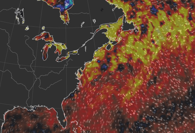
Despite Eckman Spiral-driven upwelling keeping immediate coastal waters cooler this summer, offshore waters are above average. See following graphic:
In English: It looks like the tropics are going to wake up for the lower latitudes of the Atlantic Hurricane Basin (Gulf of Mexico/Bahamas/Caribbean) in the Sept 3-10 period. I’ll be tracking this closely because a few days after any impacts to the SE US could mean tropical remnants for NJ. There are no current specific threats to New Jersey but this is the first time I’m seeing something worth monitoring. Weekend outlook will be out tomorrow. Have a great rest of your Thursday and please be safe! JC
Premium Services
KABOOM Club offers inside info forecast discussion, your questions answered, and early storm impact maps (ahead of the public). At a buck per month, it’s an extremely feasible way to show support.
My Pocket Meteorologist (MPM), in partnership with EPAWA Weather Consulting, offers professional/commercial interests, whose businesses depend on outdoor weather conditions (snow plowing, landscaping, construction, etc.), with hyper-local text message alerts/forecasts and access to the MPM premium forum—the most comprehensive and technical forecast discussion available for PA and NJ.
Jonathan Carr (JC) is the founder and sole operator of Weather NJ, New Jersey’s largest independent weather reporting agency. Since 2010, Jonathan has provided weather safety discussion and forecasting services for New Jersey and surrounding areas through the web and social media. Originally branded as Severe NJ Weather (before 2014), Weather NJ is proud to bring you accurate and responsible forecast discussion ahead of high-stakes weather scenarios that impact this great garden state of ours. All Weather. All New Jersey.™ Be safe! JC


LOCAL FORECAST | INTERACTIVE RADAR | LATEST NJ WEATHER ALERTS | WEDDING FORECAST| PRIVACY POLICY
© Copyright 2026 Weather NJ LLC. All Rights Reserved.
Some information that can be found on our website is provided by a private weather station and is not an officially recognized station for weather reporting. Though we always strive to achieve accurate reporting for our own use, it is important that you do NOT depend on the data provided here for any purpose.
