

Tuesday NWNJ Snowstorm a GO
Discussion: Currently, we have precipitation pushing through ahead of a cold front that is expected to pass through later this evening. The cold front is hooked to a low near Toronto that is pushing eastward into SE Canada/Maine. A warm front is also attached to this low and will try to push from S to N through NJ today, hence the 40-50F temp range currently across the NJ coastal plain. NWNJ elevations however are on the N side of the warm front still and remain near-freezing with trace/light accumulation of wintry precip already today. This snow season is wasting no time as we eye up Tuesday and then another wintry signal around Dec 5-6. Let’s dive into Tuesday details…
To reiterate, this is not a big deal/shut down snowstorm and mostly a rain event for the lower 2/3 of NJ. It’s only a snow event for mostly NWNJ/NNJ elevations. The energy responsible for Tuesday’s system is now off the Pacific Ocean and over the NW US land. The data is therefore much better sampled. A solid feed of subtropical stream moisture is feeding the area ahead of the NW US energy which will form the primary low responsible for Tuesday’s conditions. This low will form along the cold front that pushes through later today and ride it like a train does rails. The current expected low track should depart the E US into the Atlantic Ocean somewhere between S Delmarva and OBX and track out to either near of just inside the 70W/40N benchmark. This low will first throw the SW US/Gulf subtropical moisture northward towards NJ but will eventually throw Atlantic Ocean moisture to the NW into NJ once offshore. With ocean temps still in the 45-50 range and general climatology for this time of year (especially midday), much of the NJ coastal plain should be roasted above freezing on Tuesday. This is why we are not expecting snow to fall and accumulate for anyone along or SE of the I-95/NJTP corridor. We are also expecting only trace/light accums to the NW of the I-95/NJTP corridor up to about I-78/I-287 which could be easily washed away once any initial snow bursts change over to rain with a possible transition period of sleet.
For areas N of I-78 and NW of I-287, Tuesday is a different story as such areas are far enough away from the ocean for marine influence and will be cold enough overnight (Monday into Tuesday) to set up a colder surface for snow accumulation. Once the precipitation gets going, it will likely hold said areas under temperatures cold enough for snow to fall and stick. Temps will then drop through sunset as precipitation wraps up to preserve the stickage. With that said, if we go up a little further N, areas along and N of I-80 and NW of I-287 are ground zero for the best snow accumulations for this system.
As far as timing goes for New Jersey, precip could initially break out anytime after midnight/early Tuesday morning AM hours. Precipitation intensity should then gradually build through Tuesday morning hours and peak between mid-to-late morning and early afternoon hours, wrapping up by sundown Tuesday evening. With all of that said, here is our first official impact map for Tuesday:
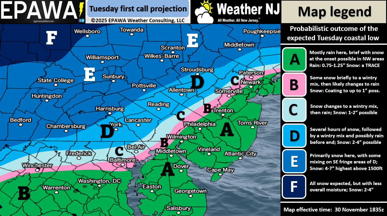
In English: Some NJ areas started wintry this morning (Sunday), but most should eventually change to rain with little-to-no accumulation and mostly a conversational snow outside of NWNJ elevations where trace/light accumulations have resulted. Temps will fall overnight tonight with a cold front pushing through and dropping most of NJ to near or below freezing by early Monday morning. Monday should then rise to a range of 32-40F (NNJ to SNJ) during the day before dropping back below freezing statewide Monday night into Tuesday morning. Snow/rain should then push in for Tuesday morning as temps rise above freezing for all areas S of I-78/SE of I-287. This means that all of SNJ/SENJ, CNJ and much of NENJ will eventually be too warm for snow to fall and accumulate despite possibly starting as snow across CNJ. NWNJ and much of NNJ, however, will likely be cold enough for snow to fall and accumulate Tuesday morning into afternoon hours. Our impact map above illustrates our initial thoughts on amounts. Everything should wrap up by sundown Tuesday evening and then we stay cold this week until our next Dec 5-6 wintry potential signal. As I said above, this is not a big deal/shut down snowstorm and mostly a rain event for the lower 2/3 of NJ. It’s only a snow event for mostly NWNJ/NNJ elevations. This snow season, however, is wasting no time getting started and we expect CNJ/SNJ to eventually get involved as well later in December. Have a great rest of your Sunday (and November rather) and please be safe! JC
Premium Services
KABOOM Club offers ad-free content, inside info forecast discussion, your questions answered, and early storm impact maps and video releases (ahead of the public). At $1.99 per month, it’s an extremely feasible way to show additional support for Weather NJ and you can turn it on and off for however many months you wish. Think of it as a tip jar with perks. Available onFacebook or Patreon.
My Pocket Meteorologist (MPM), in partnership with EPAWA Weather Consulting, offers professional/commercial interests, whose businesses depend on outdoor weather conditions (snow plowing, landscaping, construction, etc.), with hyper-local text message alerts/forecasts from real meteorologists and access to the MPM premium forum—the most comprehensive and technical forecast discussion available for PA and NJ.
KABOOM Shop is live if you want some KABOOM or Weather NJ Merch!
Jonathan Carr (JC) is the founder and sole operator of Weather NJ, New Jersey’s largest independent weather reporting agency. Since 2010, Jonathan has provided weather safety discussion and forecasting services for New Jersey and surrounding areas through the web and social media. Originally branded as Severe NJ Weather (before 2014), Weather NJ is proud to bring you accurate and responsible forecast discussion ahead of high-stakes weather scenarios that impact this great garden state of ours. All Weather. All New Jersey.™ Be safe! JC


LOCAL FORECAST | INTERACTIVE RADAR | LATEST NJ WEATHER ALERTS | WEDDING FORECAST| PRIVACY POLICY
© Copyright 2026 Weather NJ LLC. All Rights Reserved.
Some information that can be found on our website is provided by a private weather station and is not an officially recognized station for weather reporting. Though we always strive to achieve accurate reporting for our own use, it is important that you do NOT depend on the data provided here for any purpose.
