

Tuesday Snow Targeting NWNJ
Discussion: To touch on the rest of the weekend very briefly, the rest of today/tonight (Saturday PM) looks chilly and dry. Some rain (less than a quarter inch likely) could push through Sunday (late-morning through early evening) ahead of a weak cold front that will set up a colder Monday. I don’t expect wintry precipitation on Sunday but I suppose a few flakes could mix in for the higher NWNJ elevations without accumulations. Sunday’s weather is mostly to set up a cold front (with warmer rain out front of it) that will make at least NWNJ cold enough to support snow by Tuesday.
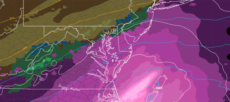
On Monday, our two weak areas of energy will be pushing across the US, from W to E, and coming together to form a weak low for the E US. This weak low should form somewhere between Delmarva and OBX and will either tuck just off the NJ coast or track further out near the 70W/40N benchmark on Tuesday. This exact track will determine how impactful the snow is to the NW of the I-95/NJTP corridor Therefore, the Tuesday event is still a go, however, we have a lot working against snow accumulation:
1) The heaviest snow will likely fall during the warmest part of Tuesday (late-morning through afternoon – maybe slightly earlier) when daily high temperatures are achieved. This would be a much different scenario if it fell overnight.
2) Climatology: Average high temperatures for Dec 2 for Philly are ~50F. Even though we will be below average, we aren’t going to be 18 degrees+ below average (32F or less) for Philly and other I-95 big cities in the middle of the day. Again, this would be a different scenario if falling overnight when average low temps (30s) would normally occur.
3) Marine Influence: Ocean temps are running 45-52F up and down the coast. Therefore, any period of this event where wind direction is between SW, S, SE, E, or even NE, the coastal plain is roasted all the way to I-95/the piedmont.
With all of that said, I still expect a wet (low snow to liquid ratio) snowfall to occur on Tuesday. My gut is telling me the snow/rain line begins somewhere near/along I-95, pushes N to about the I-78/I-287 axis, possibly the I-80/I-287 axis, and then feathers back down to the I-78/I-287 axis to end. Any slushy accumulations that occur between I-95 and I-80/I-287 before the snow/rain line advances northward will likely be wiped out after changing over to rain. You should not expect snow accumulations in NENJ, along I-95, or anywhere SE of such, only a cold rain. And that might apply as far as 20-30 miles NW of 95. This leaves NWNJ/NNJ (NW of I-78/I-287) for the best chance to see a few inches of snow accumulation when all is said and done. The only area who could exceed the current jackpot expectation of ~1-3/2-4 inches IMO would be the highest elevations of Sussex, Warren, Passaic, and Morris Counties. I imagine an area like the High Point Monument area seeing the most out of this (here’s looking at you SV!).
This is not a shut-down snow event, but it could lead to some slow-going travel Tuesday morning as precipitation initially breaks out and possibly some wintry issues for the afternoon/evening rush hour commute for untreated roads of NNJ/NWNJ elevations (not NENJ/CNJ/SNJ/NENJ – only rain-related concerns there by afternoon hours).
In English: Expect another cold night tonight (Saturday night) and then a milder Sunday daytime. Some rain (possibly flakes mixed in for NWNJ) pushes through Sunday ahead of a cold front that chills us back down for Monday into Tuesday. On Tuesday, everyone along and SE of I-95/NJTP should expect a cold rain. Areas NW of I-95/NJTP could see the first wider-spread snow accumulation of the snow season. As of right now, lower elevations of WCNJ/NENJ could start as snow but likely change to rain and have any snow accumulations wiped out. The higher elevations (NW of I-78/I-287) have the best chance to see a few inches of snow fall and stick between morning and afternoon hours. All precipitation should end around sundown Tuesday and further onward we go into the snow season. A reminder that we’re only in batting practice of the winter baseball game. But this IS nice to see this early! We’ll put our first official snow map and forecast out tomorrow, but these are the current thoughts and ideas. Everyone have a great rest of your weekend and please be safe! JC
Premium Services
KABOOM Club offers ad-free content, inside info forecast discussion, your questions answered, and early storm impact maps and video releases (ahead of the public). At $1.99 per month, it’s an extremely feasible way to show additional support for Weather NJ and you can turn it on and off for however many months you wish. Think of it as a tip jar with perks. Available onFacebook or Patreon.
My Pocket Meteorologist (MPM), in partnership with EPAWA Weather Consulting, offers professional/commercial interests, whose businesses depend on outdoor weather conditions (snow plowing, landscaping, construction, etc.), with hyper-local text message alerts/forecasts from real meteorologists and access to the MPM premium forum—the most comprehensive and technical forecast discussion available for PA and NJ.
KABOOM Shop is live if you want some KABOOM or Weather NJ Merch!
Jonathan Carr (JC) is the founder and sole operator of Weather NJ, New Jersey’s largest independent weather reporting agency. Since 2010, Jonathan has provided weather safety discussion and forecasting services for New Jersey and surrounding areas through the web and social media. Originally branded as Severe NJ Weather (before 2014), Weather NJ is proud to bring you accurate and responsible forecast discussion ahead of high-stakes weather scenarios that impact this great garden state of ours. All Weather. All New Jersey.™ Be safe! JC


LOCAL FORECAST | INTERACTIVE RADAR | LATEST NJ WEATHER ALERTS | WEDDING FORECAST| PRIVACY POLICY
© Copyright 2026 Weather NJ LLC. All Rights Reserved.
Some information that can be found on our website is provided by a private weather station and is not an officially recognized station for weather reporting. Though we always strive to achieve accurate reporting for our own use, it is important that you do NOT depend on the data provided here for any purpose.
