

Turning Colder Again. Sunday night NWNJ Snow?
Discussion: Real quick, most areas should fall into the upper-20s/lower-30s tonight. This should end the very mild conditions we saw this week. I know I have been eyeing up the Dec 11-17 period for favorable snowstorm development conditions in prior articles, mainly because of the highly anomalous blocking signal. The block was well modeled, came into fruition now, and will be around Greenland into next week. What hasn’t cooperated yet is the desired +PNA (W US ridge) signal. But we do have two approaching signals. First is this Sunday (Dec 11) and then again on Dec 15. I will likely be updating tomorrow and over the weekend on what to expect Sunday night. It’s rain for the lower-2/3 of NJ but areas N of I-80 and NW of I-287 could def see snow. Whatever happens on Dec 15, a pattern-shifting cold front should then knock us into a January feel for the following week. There are then two long-range signals to monitor…~Dec 23 and ~Dec 26. Basically, the desired neutral to +PNA has been slightly delayed. I will continue to track this closely.
Friday (Dec 9) high temperatures should reach the mid-to-upper 40s. Skies should be mostly sunny. Winds should be light out of the N. Overnight lows should dip into the 20s for most. NWNJ elevations might dip into upper-teens while coastal regions hang in the lower-30s.
Saturday (Dec 10) high temperatures should reach the low-to-mid 40s for most, maybe upper-40s closer to the ocean. Skies should be mixed with sun and clouds. Winds should be light out of the NE. Overnight lows should range from upper-20s to near-40 from elevations to coasts.
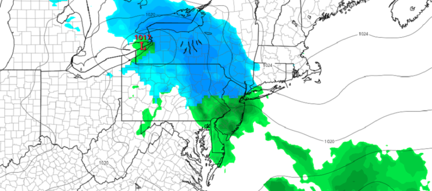
Sunday (Dec 11) high temperatures should range from mid-30s to near-50 from elevations to coasts. Quite the difference between NWNJ elevations and SENJ coasts. Periods of rain are likely to start during the day and extend into overnight hours. A snow/rain line is possible across NNJ meaning areas N of I-80/NW of I-287 might see snow start to accumulate once later in the night. Likely no accumulations during the day when temps are above freezing. I am watching this closely and will report accordingly over next few days. Winds should be light out of the E/NE. Overnight lows should range from mid-20s to mid-30s from elevations to coasts with again…a snow/rain line likely developing across NNJ/NWNJ…meaning likely just rain for NENJ, CNJ, and SNJ.
An early look at next week indicates highs in the upper-30s/40s and lows in the 20s/lower-30s meaning too warm for snow to stick during the day but cold enough for snow to stick at night. The first signal I am watching is this Sunday night (Dec 11) mainly for NNJ/NWNJ. I will report more in the coming days. Another signal exists for the Dec 15/16 time frame which could include more of NJ for snow. After that, the pattern is expected to turn colder and likely remain active heading into Christmas. Have a great weekend and please be safe! JC
Premium Services
KABOOM Club offers inside info forecast discussion, your questions answered, and early storm impact maps (ahead of the public). At a buck per month, it’s an extremely feasible way to show support.
My Pocket Meteorologist (MPM), in partnership with EPAWA Weather Consulting, offers professional/commercial interests, whose businesses depend on outdoor weather conditions (snow plowing, landscaping, construction, etc.), with hyper-local text message alerts/forecasts and access to the MPM premium forum—the most comprehensive and technical forecast discussion available for PA and NJ.
Jonathan Carr (JC) is the founder and sole operator of Weather NJ, New Jersey’s largest independent weather reporting agency. Since 2010, Jonathan has provided weather safety discussion and forecasting services for New Jersey and surrounding areas through the web and social media. Originally branded as Severe NJ Weather (before 2014), Weather NJ is proud to bring you accurate and responsible forecast discussion ahead of high-stakes weather scenarios that impact this great garden state of ours. All Weather. All New Jersey.™ Be safe! JC


LOCAL FORECAST | INTERACTIVE RADAR | LATEST NJ WEATHER ALERTS | WEDDING FORECAST| PRIVACY POLICY
© Copyright 2025 Weather NJ LLC. All Rights Reserved.
Some information that can be found on our website is provided by a private weather station and is not an officially recognized station for weather reporting. Though we always strive to achieve accurate reporting for our own use, it is important that you do NOT depend on the data provided here for any purpose.
