

Unsettled Conditions (Jan 24-26)
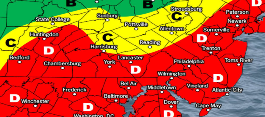
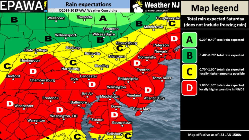
Discussion: Conditions should remain tranquil and milder for Friday. An Upper-Level Low (ULL) will then barrel across the NE US this weekend tracking near the Appalachian Mountain range. A surface low will correlate and wobble through somewhere near/over NJ on Saturday and this will be the rain-maker. I’m expecting a slug of moderate-to-heavy rainfall to push through NJ from W to E between sunrise and afternoon on Saturday. Since rainfall is expected to be heavy in a short time flash flooding is possible. I wouldn’t be surprised to see a few boomers embedded in the heavy rainfall. It’s not a sure thing but the dynamics wouldn’t be unsupportive. The following rain impact map shows expected rainfall amounts in that time period:
Click here to view full-resolution ice impact map!
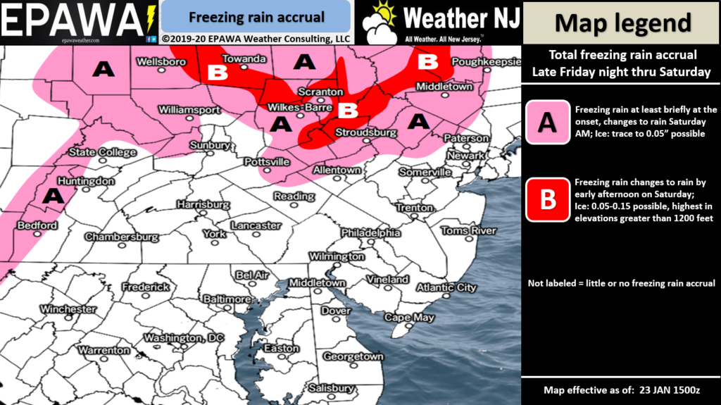
The below ice impact map shows a small concern for initial freezing rain in NWNJ. This concern is warranted by surface temperatures in the mountains slow to rise above freezing—while precipitation initially moves in:
Click here to view full-resolution ice impact map!
Conditions should then improve by late-afternoon and especially by Saturday night. Onshore flow is currently establishing from the SE Canadian high. The surface low on Saturday will ramp up the onshore flow even more which justifies a risk for coastal flooding along the SENJ and ECNJ ocean-facing coasts. The two Saturday high tides would be the periods of greatest concern with minor coastal flooding likely and a small chance of moderate risk. Once this system gets off to our E there’s a small chance of some wraparound flurries or even snow showers pushing through Sunday-Sunday night. NWNJ elevations would be most-favored for such.
The next synoptic storm signal is for next weekend, Feb 1-2, and has my interest. This would be the first Miller-A system of the season. A Miller-A is a low that tracks from the Gulf of Mexico region up the E coast without a transfer. If this were to pass over OBX and the 40N/70W benchmark we’d be talking a major snow storm. I’ll be tracking this through the weekend and will begin reporting on it Sunday if the signal is still screaming. Please understand that it is just a signal for now and is still considered a long-range possibility. Something to track though as we enter peak snow season for the Mid-Atlantic US (February).
Friday (Jan 24) high temperatures should reach the mid-to-upper 40s for most areas. Skies should be partly sunny. Winds should be light out of the E. Overnight lows should range from near-30 to mid-40s NNJ to SNJ.
Saturday (Jan 25) high temperatures should range from near-40 to near-50 NNJ to SNJ. Parts of SNJ might even break into the lower-50s. Skies should start mostly cloudy with periods of heavy rain possible between sunrise and afternoon hours (see above rain impact map). A small chance of embedded boomers and gusty winds within the rainfall. Winds should remain strong off the ocean through afternoon hours but then switch to the NW heading into overnight hours. Both flash and coastal flooding are possible during earlier rainy hours. Overnight lows should range from near-30 to near-40 as conditions improve.
Sunday (Jan 26) high temperatures should reach the low-to-mid 40s for most areas. Skies should be mixed with sun and clouds. Winds should be light out of the W. Overnight lows should range from upper-20s to mid-30s NNJ to SNJ. There’s a small chance of overnight flurries and snow showers mainly for NWNJ elevations.
An early look at next week indicates generally dry conditions with highs in the 38-45 range and lows in the 25-34 range. The next synoptic storm signal I’m tracking, capable of producing snow, is the February 1-2 period (next weekend). This Sunday would be the first day of official reporting if the signal holds between now and then. Everyone have a great weekend and please be safe! JC
Download the new free Weather NJ mobile app on Apple and/or Android. It’s the easiest way to never miss Weather NJ content. Our premium services go even further above and beyond at the hyper-local level. Looking for industrial-caliber long-range forecasting data that I personally recommend? Check out WeatherTrends360! Visit the Weather NJ Kaboom Shop for hoodies, tees and infant onesies.
Jonathan Carr (JC) is the founder and sole operator of Weather NJ, New Jersey’s largest independent weather reporting agency. Since 2010, Jonathan has provided weather safety discussion and forecasting services for New Jersey and surrounding areas through the web and social media. Originally branded as Severe NJ Weather (before 2014), Weather NJ is proud to bring you accurate and responsible forecast discussion ahead of high-stakes weather scenarios that impact this great garden state of ours. All Weather. All New Jersey.™ Be safe! JC


LOCAL FORECAST | INTERACTIVE RADAR | LATEST NJ WEATHER ALERTS | WEDDING FORECAST| PRIVACY POLICY
© Copyright 2026 Weather NJ LLC. All Rights Reserved.
Some information that can be found on our website is provided by a private weather station and is not an officially recognized station for weather reporting. Though we always strive to achieve accurate reporting for our own use, it is important that you do NOT depend on the data provided here for any purpose.

)