

Wait, it could snow again on Monday?
Discussion: The January thaw is underway, and rain is starting to trickle into the region. Rain will fill into more of NJ overnight tonight (Wednesday night) with a more widespread rain expected through Thursday ending Friday morning. We should then see a break in the rain later Friday through Saturday. Rain then returns Sunday and continues Sunday night into Monday morning. It will be unseasonably mild through this weekend right into Monday morning. We have a Bermuda high pumping warmer SW return flow into NJ basically from now until Monday morning. Expect temps to spike into the 50s (even near-60) at times during the rainfall. Friday looks like the warmest point. But otherwise, a warmer weekend with on-and-off periods of rain between now and then.
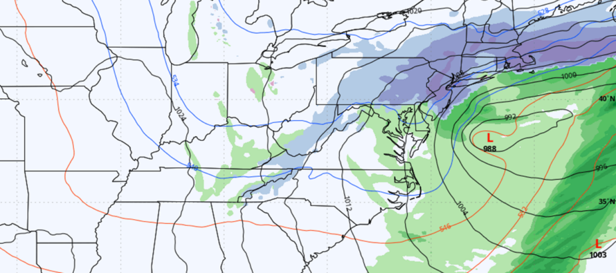
On Monday, something interesting happens. I mentioned this two days ago in the Monday-Friday outlook but it has only gained support since. An upper-level low/small trough meanders from Texas eastwards to just S of NJ. A low-mid level area of high pressure in Canada then escorts a surface low through the E US below it (to the S of it). The high in Canada pulls down very cold air from E Canada and injects it into the precipitation shield on Monday. This would theoretically change rain to snow from N to S or NW to SE during Monday and most of NJ would then finish with snowfall. NWNJ would be most favored for accumulations. SENJ would be least favored. There is upper-level support for this to happen. We have a +PNA and near-neutral AO/NAO going positive right after this event (a tell IMO). We have cold air available starting late Sunday night. I will however say that this is a thread the needle event and requires specific timing to come into fruition. But so far the models are saying it’s there. Today, the GFS is less impressed by the potential. The Canadian model, and especially the Euro model, are much more impressed. The ensembles of the three bigs are supportive though, and that’s why I am interested.
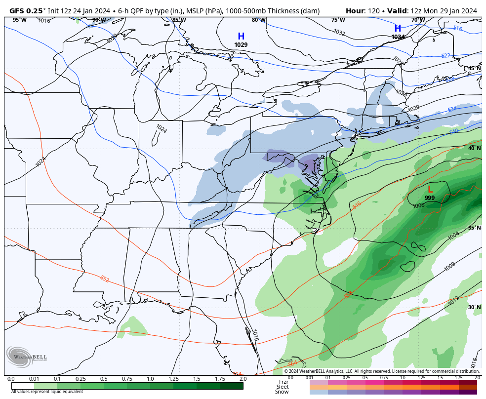
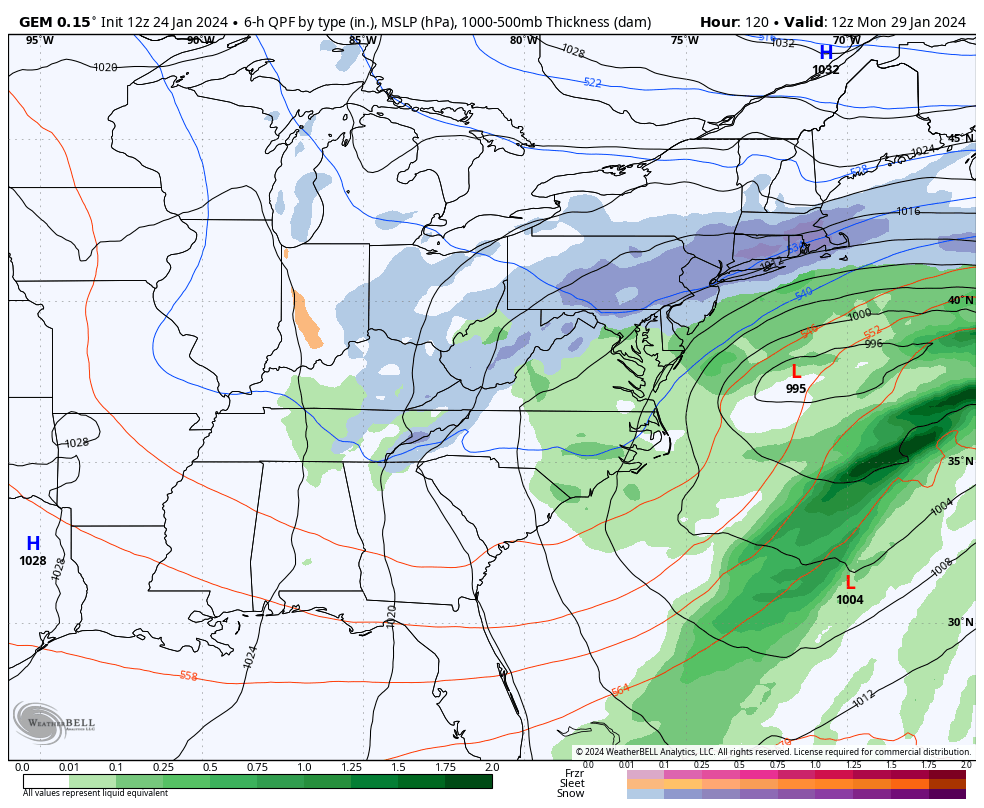
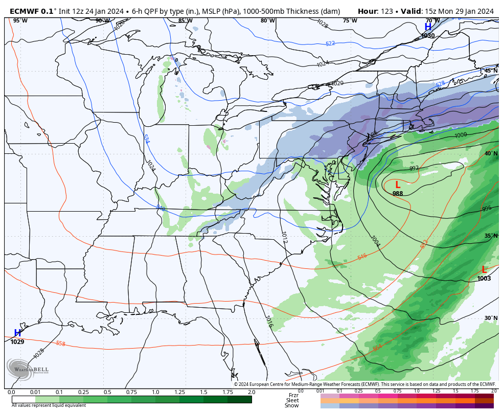
So, for timing, rain would start changing to snow later Sunday night in extreme NNJ first. Then between about midnight and 9am Monday, rain would change to snow, generally from NW to SE. It would then snow from 9am to maybe Monday late-afternoon/early-evening. SENJ would be last to changeover to snow and therefore would see the least amount of snow accumulation after a mostly all-rain event. Areas along and NW of the turnpike however could be in for a surprise. I don’t see many talking about this yet.
I am also seeing a possible snow event on Groundhog Day as well as another storm signal in the Feb 9 period. Like I said in the prior article a few days ago, enjoy the January thaw because winter is not over.
In English: We’re in for a stretch of milder temperatures and rainfall between now and Monday morning. We should see a break in the rain for Friday-Saturday, but milder temps will remain in place. It’s then possible for rain to change to snow between late-Sunday night and Monday morning as much colder air moves in. I’m already anticipating your comments “It’s too warm for snow, my app says this, my app says that.” Please, just don’t. If cold air moves in the way it is modeled, the rain will change to snow. See Nemo in February of 2013 if you need a similar example of how it happens. I am going to give this one more day of casual monitoring (I’m still not all-in). If still advertised on the data tomorrow afternoon, then I will shift into a more serious storm tracking mode. It doesn’t look like a major snowstorm but even just another significant snowstorm could place many areas above-average (for where they should be Jan 29) for total winter snowfall. Have a great rest of your Wednesday and please be safe! JC
Premium Services
KABOOM Club offers inside info forecast discussion, your questions answered, and early storm impact maps (ahead of the public). At a buck per month, it’s an extremely feasible way to show support.
My Pocket Meteorologist (MPM), in partnership with EPAWA Weather Consulting, offers professional/commercial interests, whose businesses depend on outdoor weather conditions (snow plowing, landscaping, construction, etc.), with hyper-local text message alerts/forecasts and access to the MPM premium forum—the most comprehensive and technical forecast discussion available for PA and NJ.
Get your KABOOM Inside Out pajamas and more at the KABOOM shop!
Jonathan Carr (JC) is the founder and sole operator of Weather NJ, New Jersey’s largest independent weather reporting agency. Since 2010, Jonathan has provided weather safety discussion and forecasting services for New Jersey and surrounding areas through the web and social media. Originally branded as Severe NJ Weather (before 2014), Weather NJ is proud to bring you accurate and responsible forecast discussion ahead of high-stakes weather scenarios that impact this great garden state of ours. All Weather. All New Jersey.™ Be safe! JC


LOCAL FORECAST | INTERACTIVE RADAR | LATEST NJ WEATHER ALERTS | WEDDING FORECAST| PRIVACY POLICY
© Copyright 2026 Weather NJ LLC. All Rights Reserved.
Some information that can be found on our website is provided by a private weather station and is not an officially recognized station for weather reporting. Though we always strive to achieve accurate reporting for our own use, it is important that you do NOT depend on the data provided here for any purpose.
