

Warmer Pattern Sets Up
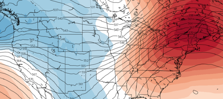
Discussion: I’m seeing a lot of ridging (see above image) building over the NE US for the next few weeks. This spells a warm pattern that could carry through the first third to half of January 2023. At the lower levels, we’ll likely see a series of high-pressure centers track to the Bermuda area and drive SW flow into NJ. This should push most temps into the 50s for New Jersey and in some cases lower-60s. The first high does it over the next few days and the next high then likely does it Jan 1-4. In-between those periods, we’ll see return flow convergence combine with an approaching warm sector to generate a synoptic rain signal Dec 31 into Jan 1. So mild and dry for a few days, rain NYE into NYD, then mild and dry for a few more days. It does look to step down cooler for Jan 5-6 but still above average…highs in the 40s/50s rather than lower-60s. Jan 7-8 is the next signal I am monitoring. It would be a thread-the-needle situation in an unfavorable pattern for snow. But hey, we just saw squat from a favorable snow pattern so why not. Looks like a weak trough could scoop up a surface low from the SE US with just enough cold from a high to the N. Other than that, I don’t see much snow possibility through at least Jan 10. But it does look like the cold returns behind whatever happens Jan 7-8.
Wednesday (Dec 28) high temperatures should reach the mid-to-upper 40s for most of New Jersey. Skies should be mixed with sun and clouds. Winds should be light out of the SW. Overnight lows should range from mid-20s to mid-30s from elevations to coasts.
Thursday (Dec 29) high temperatures should at least reach the upper-40s for most of New Jersey, maybe even low-to-mid 50s along the coastal plain. Skies should be mixed with sun and clouds. Winds should be light out of the SW. Overnight lows should range from upper-20s to upper-30s from elevations to coasts.
Friday (Dec 30) high temperatures should reach the low-to-mid 50s for most of New Jersey. Skies should be mixed with sun and clouds. Winds should be light out of the SW. Overnight lows should range from mid-30s to mid-40s from elevations to coasts.
Saturday (Dec 31) high temperatures should reach into the 50s for most areas. Some CNJ SNJ areas might flirt with 60. Clouds should build early and rain should eventually move in by afternoon-evening. Periods of rain are then expected during overnight hours which could impact events like the ball dropping/outdoor parties/etc. If that impacts you, then you might want to consider an indoor audible if possible. Winds should be light-to-breezy out of the S. Overnight lows should fall into the 40s as rain continues into 2023.
Sunday (Jan 1) high temperatures should generally range from 50-60 from elevations to coasts, maybe low 60s for SNJ. Skies should remain mostly cloudy with periods of rain ending sometime during AM hours. Should taper off by noon for all areas. Skies should then improve with a mild feel. It will probably feel like spring. Winds should be light-to-breezy out of the W. Overnight lows should fall into the low-to-mid 40s for most of New Jersey
The long-range look indicates temperatures staying above average for at least the first week of January 2023. Jan 1-4 looks like the warmest it will get (temps breaking 60 for many areas). Jan 5-6 looks like a step-down to just 40s/50s. Then Jan 7-8 is the next possible wintry storm signal I am casually monitoring. There are some more details in the above discussion but we are a long way away. I only recommend following it from this range if you’re a weather nerd like me. Otherwise, enjoy the milder weather and the break in energy utilities that goes along with it. I’ll check back in on Thursday or Friday if anything has changed for NYE/NYD rain. Be safe! JC
Premium Services
KABOOM Club offers inside info forecast discussion, your questions answered, and early storm impact maps (ahead of the public). At a buck per month, it’s an extremely feasible way to show support.
My Pocket Meteorologist (MPM), in partnership with EPAWA Weather Consulting, offers professional/commercial interests, whose businesses depend on outdoor weather conditions (snow plowing, landscaping, construction, etc.), with hyper-local text message alerts/forecasts and access to the MPM premium forum—the most comprehensive and technical forecast discussion available for PA and NJ.
Jonathan Carr (JC) is the founder and sole operator of Weather NJ, New Jersey’s largest independent weather reporting agency. Since 2010, Jonathan has provided weather safety discussion and forecasting services for New Jersey and surrounding areas through the web and social media. Originally branded as Severe NJ Weather (before 2014), Weather NJ is proud to bring you accurate and responsible forecast discussion ahead of high-stakes weather scenarios that impact this great garden state of ours. All Weather. All New Jersey.™ Be safe! JC


LOCAL FORECAST | INTERACTIVE RADAR | LATEST NJ WEATHER ALERTS | WEDDING FORECAST| PRIVACY POLICY
© Copyright 2026 Weather NJ LLC. All Rights Reserved.
Some information that can be found on our website is provided by a private weather station and is not an officially recognized station for weather reporting. Though we always strive to achieve accurate reporting for our own use, it is important that you do NOT depend on the data provided here for any purpose.
