

Watching a Coastal Storm (Oct 18-20)
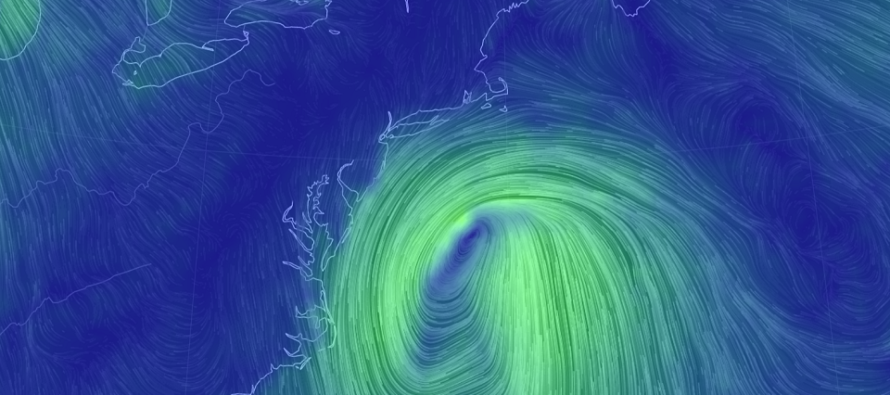
Discussion: A trough will move out with the departing nor’easter. But not before keeping the region colder and still-breezy tonight (Thursday) through part of Friday. Upper-level heights should then build from Saturday through Tuesday. This should keep it dry with sunny highs in the 60s except for Sunday. A tropical system is developing in the SW Gulf of Mexico. If this system forms it would be named Nestor. For now it’s just Tropical Cyclone 16 per the NWS National Hurricane Center. It is expected to cross the Gulf of Mexico from SW to NE and then cross the SE US and emerge into the Atlantic Ocean near OBX. From there it should speed away out-to-sea. NJ, especially SENJ, has a chance to see rain and wind from the N and NW side of the system. It’s simply too uncertain at the moment. Verbatum model data would say only the extreme SENJ coast has a chance for sprinkles and darker skies. Any slight shift NW however and it brings most of NJ, SE of the Turnpike, into rainfall. Winds don’t look too bad with this. Nothing like we saw last night (Wednesday night). Also the period of onshore flow is short so only a minor concern for coastal flooding. I plan to do an article tomorrow with a closer look at Sunday impacts. Conditions should remain mild through Tuesday but then a cold front should pass through with rain Tuesday night. A stronger cold front is expected to pass through next weekend.
Friday (Oct 18) high temperatures should struggle to escape the 50s. SNJ has the best chance to reach 60. Skies should be partly sunny. Winds should be breezy out of the NW. Overnight lows should fall into the 30s for most areas with coastal SNJ hanging in the lower-40s. If skies are clear and winds subside then overnight temperatures could drop even lower.
Saturday (Oct 19) high temperatures should reach the lower-60s for most areas. Skies should be mostly sunny. Winds should be light out of the W. Overnight lows should range from near-40 to near-50 NNJ to SNJ.
Sunday (Oct 20) high temperatures should reach the low-to-mid 60s for most areas. SENJ has the best chance to see some light-to-moderate rain and moderate wind from a quickly moving out-to-sea passing coastal storm. The further NW you are from SENJ the better chance you have to stay dry and possibly see some sun. The brief period of storm-related onshore flow could bring minor levels of coastal flooding on Sunday. I will put out a full update tomorrow to better anticipate Sunday conditions.
An early look at next week indicates a milder Monday-Tuesday with highs well into the 60s. A cold front is expected Tuesday night which should take us down for Wednesday. I’d expect some rainfall along and ahead of that cold front Tuesday PM. A slight rebound milder for Thursday then another stronger cold front sometime next weekend. That one should remind us that winter is coming.
Download the new free Weather NJ mobile app on Apple and/or Android. It’s the easiest way to never miss Weather NJ content. Our premium services go even further above and beyond at the hyper-local level. Looking for industrial-caliber long-range forecasting data that I personally recommend? Check out WeatherTrends360!
Jonathan Carr (JC) is the founder and sole operator of Weather NJ, New Jersey’s largest independent weather reporting agency. Since 2010, Jonathan has provided weather safety discussion and forecasting services for New Jersey and surrounding areas through the web and social media. Originally branded as Severe NJ Weather (before 2014), Weather NJ is proud to bring you accurate and responsible forecast discussion ahead of high-stakes weather scenarios that impact this great garden state of ours. All Weather. All New Jersey.™ Be safe! JC


LOCAL FORECAST | INTERACTIVE RADAR | LATEST NJ WEATHER ALERTS | WEDDING FORECAST| PRIVACY POLICY
© Copyright 2026 Weather NJ LLC. All Rights Reserved.
Some information that can be found on our website is provided by a private weather station and is not an officially recognized station for weather reporting. Though we always strive to achieve accurate reporting for our own use, it is important that you do NOT depend on the data provided here for any purpose.

)