

Watching the Weekend (Jan 27-31)
Discussion: Most are focused on this weekend’s winter storm potential. Let’s get the week ahead out of the way first. Upper-level height anomalies should remain negative through most of this week. This indicates colder air aloft with general flow out of the colder quadrant (between W and N). We start this week with highs reaching into the lower-40s but by mid-week highs should struggle to escape the 30s. Overnight lows Wednesday and Thursday night should likely represent the coldest part of the week with temperatures well-below freezing. A transient weak ridge should then float through for most of Friday into Saturday morning. This could take us back into the lower-40s for highs Friday and even Saturday before the cold air returns by Saturday night. Outside of some lake-effect flurries (NWNJ favored) earlier in the week it looks mostly dry from now until storm time Saturday night. Now let’s talk about what you are all most concerned with.
Last Thursday I identified a strong but general synoptic storm signal on the long-range ensembles (GEFS and EPS). I made it known how it is foolish to consider the surface output of the guidance from that range and I’ll repeat that it is still foolish to do so at this time. It is much more productive to consider 500mb prognostication and the favorability of the pattern to support a winter storm system. The only surface data worth considering right now IMO are the mean surface pressure anomalies from ensembles and how they relate to the 500mb look. Precipitation type, precipitation amounts and wind speeds are simply surface details that we will not forecast until it’s snow map time. We’re talking Tuesday at the earliest, likely Wednesday, if the signal is still showing with consensual model and real-time obs support. It is Sunday however and we’re three days closer than we were last Thursday. We’re now inside the 7-day forecasting window of this system and it’s time to report.
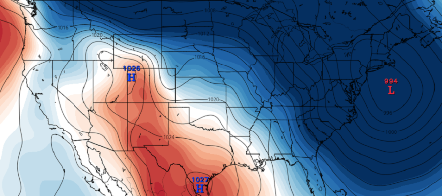
Guidance is almost unanimous in an upper-level W US ridge + E US trough for the storm signal period. Guidance is also almost unanimous in a tighter clustering of mean surface level pressure in the 40N 70W benchmark area (see above cover image). All of these signals have remained consistent on model guidance through the weekend and that’s all I was looking for. I see some news orgs/sites have jumped the gun already. Some claiming Super Bowl Blizzard in favor of the storm. Others bitter-casting and hating the possibility—issuing early dismissals because “this winter has sucked so far.” Let’s all take a deep breath and relax. The signal is still showing but we still need a few days to transition from that to estimating surface conditions. The signal has not dropped off and that’s about all you can say at this point.
The system would primarily be a Miller-A system (low originates near/in Gulf of Mexico and tracks up the E US coast). We also have a northern stream of energy that if timed right (with southern stream interaction) would blow up into a major cold snow storm for most of the Mid-Atlantic US. Less interaction between the northern and southern energy would mean a weaker and strung-out result of less precipitation and milder conditions. These are the things I’ll be watching in the next few days as we transition from long-range signal tracking to mid-range forecasting. I doubt you would see snow maps issued by us until Wednesday. In the mean time just know that the signal is still there and I’ll likely report daily on such at 5pm. Try not to get juked out of your socks on the surface output. Some runs will show hits. Others will show misses. It’s the nature of the game.
Personally? With no scientific backing? I like this storm system even though it’s a thread the needle event. I’ve liked this system since Thursday but you know that. We then have several more storm signals in an even more favorable winter pattern in the first half of February. For now let’s focus on this one.
Monday (Jan 27) high temperatures should reach the low-to-mid 40s for most areas. Skies should be mixed with sun and clouds. Winds should be light out of the W/SW. Overnight lows should range from mid-20s to near-freezing NNJ to SNJ.
Tuesday (Jan 28) high temperatures should range from upper-30s to lower-40s NNJ to SNJ. Skies should again be mixed with sun and clouds. Winds should be light out of the NW. Overnight lows should range from mid-20s to near-freezing NNJ to SNJ.
Wednesday (Jan 29) high temperatures should struggle to escape the 30s for most areas. Skies should be mostly sunny. Winds should be light out of the N/NW. Overnight lows should range from mid-teens to mid-20s NNJ to SNJ.
Thursday (Jan 30) high temperatures should again struggle to escape the 30s for most areas. Skies should be mostly sunny. Winds should be light out of the N/NE. Overnight lows should range from near-20 to near-30 NNJ to SNJ.
Friday (Jan 31) high temperatures should reach the lower-40s for most areas. Skies should gradually increase in cloudiness throughout the day. Winds should be light out of the W. Overnight lows should range from mid-20s to mid-30s NNJ to SNJ.
An early look at the weekend indicates a strong synoptic storm signal and possibly with wintry precipitation impacting Super Bowl Sunday plans and schools Monday morning. This would make the system very high stakes regarding widespread impact. Please see the above discussion for details and tomorrow I’ll likely start daily 5pm articles monitoring the signal. We’re still a few days away from considering surface output seriously. But chances are increasing in a coastal winter storm for the Mid-Atlantic and Northeast US in the late-Saturday through Sunday/early-Monday period of this incoming weekend. Everyone have a great week in the meantime and please be safe! JC
Download the new free Weather NJ mobile app on Apple and/or Android. It’s the easiest way to never miss Weather NJ content. Our premium services go even further above and beyond at the hyper-local level. Looking for industrial-caliber long-range forecasting data that I personally recommend? Check out WeatherTrends360! Visit the Weather NJ Kaboom Shop for hoodies, tees and infant onesies.
Jonathan Carr (JC) is the founder and sole operator of Weather NJ, New Jersey’s largest independent weather reporting agency. Since 2010, Jonathan has provided weather safety discussion and forecasting services for New Jersey and surrounding areas through the web and social media. Originally branded as Severe NJ Weather (before 2014), Weather NJ is proud to bring you accurate and responsible forecast discussion ahead of high-stakes weather scenarios that impact this great garden state of ours. All Weather. All New Jersey.™ Be safe! JC


LOCAL FORECAST | INTERACTIVE RADAR | LATEST NJ WEATHER ALERTS | WEDDING FORECAST| PRIVACY POLICY
© Copyright 2026 Weather NJ LLC. All Rights Reserved.
Some information that can be found on our website is provided by a private weather station and is not an officially recognized station for weather reporting. Though we always strive to achieve accurate reporting for our own use, it is important that you do NOT depend on the data provided here for any purpose.

)