

Watching Two Snow Events
Discussion: Two snow events are on the table this week, one for Thursday and another for Saturday. Let’s break them down.
Thursday looks like a generally light event. After a milder day in the 40s (Wednesday), rain should begin approaching late Wednesday night and spread into much of New Jersey by early Thursday morning. An Arctic front will push through the rain between mid and late Thursday morning, from NW to SE, and change it all over to snow. The surface line of freezing will fall below freezing shortly after the changeover. NWNJ will be first to end. SENJ will be last to end. It looks like a general widespread 1-3 is likely across most of NJ after the changeover. I could see that being a very icy 1-3 inches beneath the snow with any standing rain water or wet surfaces freezing. Snow should then clear to the E later Thursday afternoon-evening and temperatures will drop with the Arctic cold air advection.
Saturday’s system has trended S and E on the overall 12Z data package. This is mainly due to some differences in shortwave timing. The Euro was less wrapped up and allowed a significant snowstorm to still graze SNJ/SENJ but took most of NNJ/CNJ out of the game. The GFS held energy back from the primary wave and gave it to the S stream. This produced a fringe graze of SNJ Saturday with a statewide coastal hit early Sunday…but overall, only produced plowable (barely) snowfall, not major snowfall. The Canadian is the least bullish with a more solid snowfall Thursday and a miss to the SE Saturday. I expect more flopping around through tomorrow but by tomorrow evening, we should be arriving at a general consensus.
I will continue to monitor the data as it releases and again, expect more variance in the next 24-hours. Saturday (possibly into Sunday) has low confidence in being a major snowstorm at this point however it does have potential to trend back that way if the data stiffs out the right shortwave timing. Thursday has much higher confidence in being a light event statewide. Beyond these two systems there are more every 3-4 days apart into the Long Range.
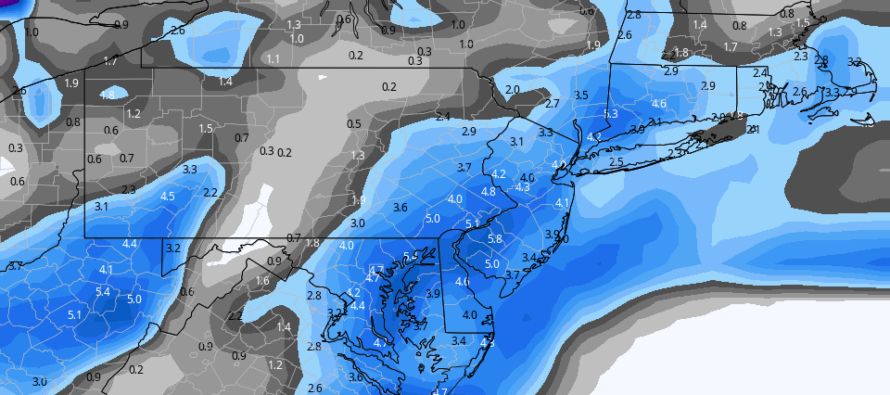
In English: Expect rain to change to snow Thursday morning and produce up to a few inches of snow statewide…1-3 maybe 2-4 type thing…by Thursday night. We then turn much colder Thursday night and through Friday. On Saturday, a snowstorm is still showing however models today are suggesting a possible (not guaranteed) SNJ/SENJ graze rather than a statewide major hit. I expect this to flop around some more and will hopefully have a much better idea of a consensus by tomorrow evening. I haven’t taken anything off the table yet and still admire the general signal. But if you are keeping score, the Euro has caved a bit towards the GFS/Canadian data. The above image represents the GFS snowfall from both the weaker Thursday wave and the Saturday-Sunday system. It’s just for reference and is not a forecast. The models should come into better agreement (whatever that is – hit or miss) by tomorrow afternoon. Have a great rest of your Tuesday and please be safe! JC
Download the free Weather NJ mobile app on Apple or Android. It’s the easiest way to never miss Weather NJ content. Our premium services go even further above and beyond at the hyper-local level.
Jonathan Carr (JC) is the founder and sole operator of Weather NJ, New Jersey’s largest independent weather reporting agency. Since 2010, Jonathan has provided weather safety discussion and forecasting services for New Jersey and surrounding areas through the web and social media. Originally branded as Severe NJ Weather (before 2014), Weather NJ is proud to bring you accurate and responsible forecast discussion ahead of high-stakes weather scenarios that impact this great garden state of ours. All Weather. All New Jersey.™ Be safe! JC


LOCAL FORECAST | INTERACTIVE RADAR | LATEST NJ WEATHER ALERTS | WEDDING FORECAST| PRIVACY POLICY
© Copyright 2026 Weather NJ LLC. All Rights Reserved.
Some information that can be found on our website is provided by a private weather station and is not an officially recognized station for weather reporting. Though we always strive to achieve accurate reporting for our own use, it is important that you do NOT depend on the data provided here for any purpose.
