

Watching Two Snow Signals Now

Discussion: The first cold front, the one attached to last night’s system has pushed through NJ today. Many started today in the 50s, some near-60, but have now been knocked down to the 40s in peak afternoon sunlight. Temps will drop even more this evening after sundown and eventually put all of NJ below freezing overnight into Sunday morning. Sunday could then just break into the 40s before the second gear of cold arrives in the form of an Arctic front. This should knock NJ down into the 30s between late Sunday morning and afternoon. Show showers and squalls are possible on Sunday between about 9am and 1pm, right along the Arctic front like thunderstorms in the warmer months. These could drop a quick coating to an inch but their main hazard would be temporary blinding visibility. These things should look like gnarly dark shelf clouds when they approach. NJ should then expect teens overnight into Monday morning. All of NJ could stay below freezing from Sunday night through Monday and right into the Tuesday snow (whether light or significant). We then stay in the colder pattern through next weekend until about Jan 22.
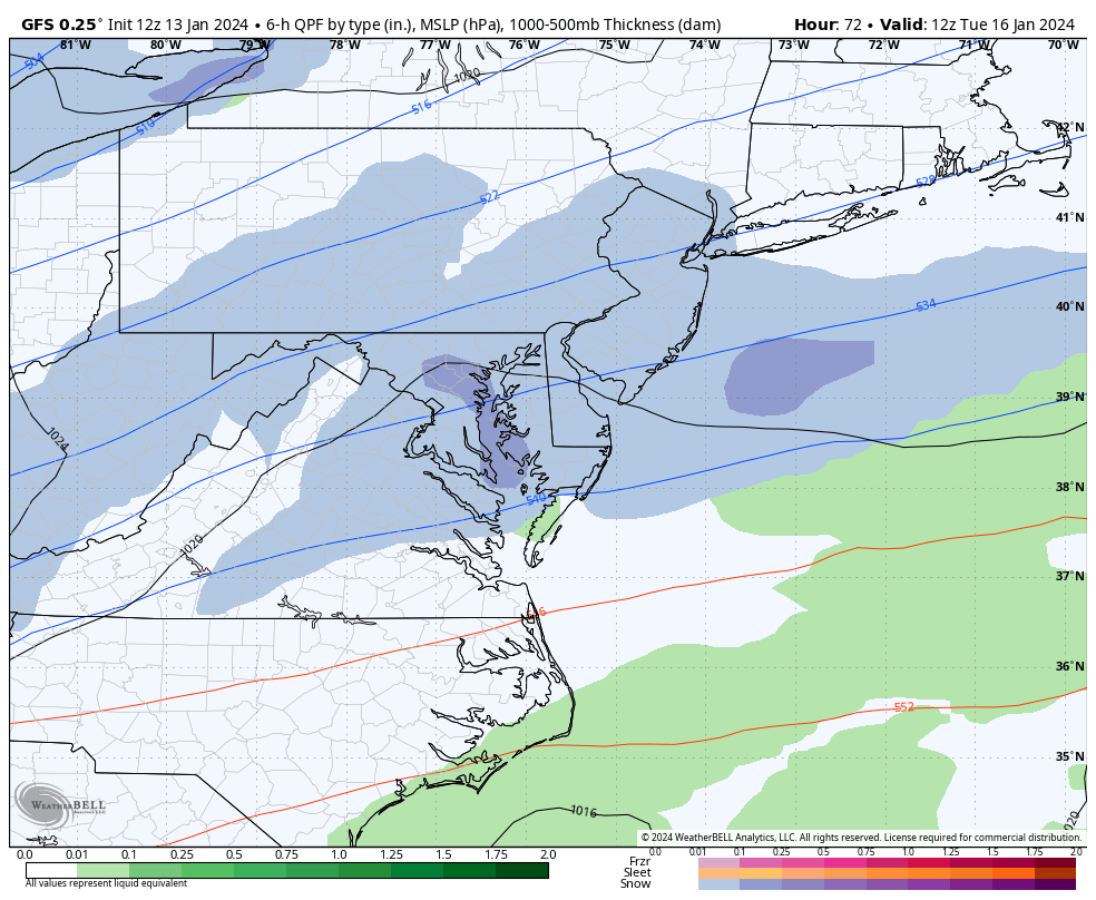
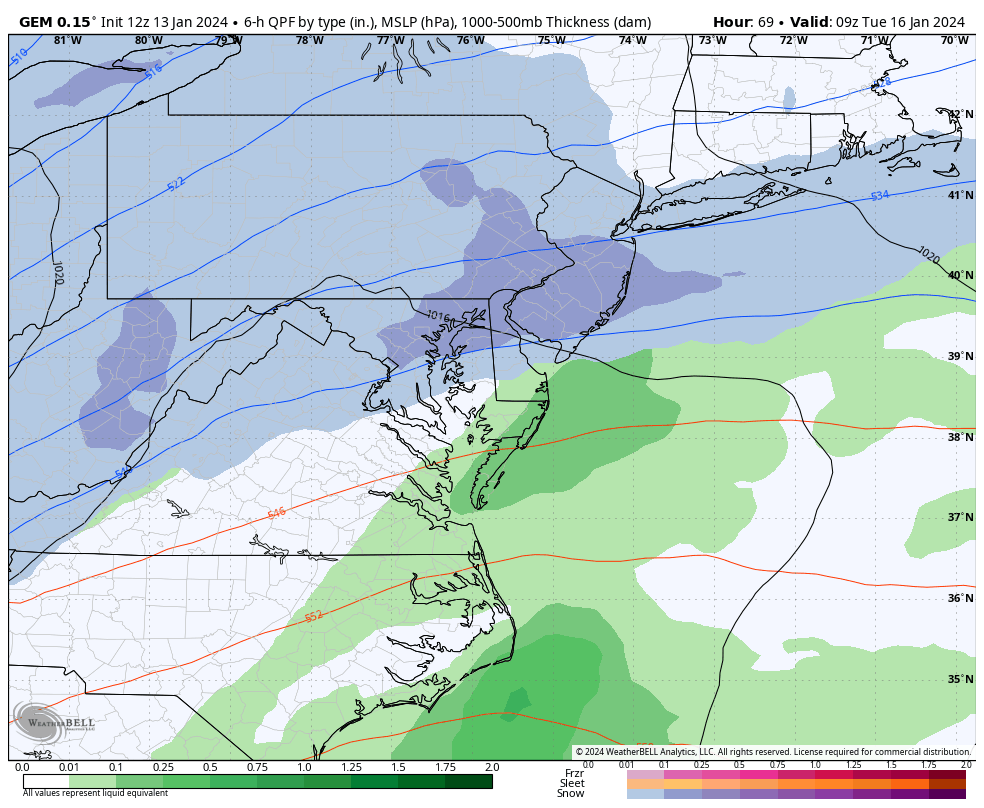
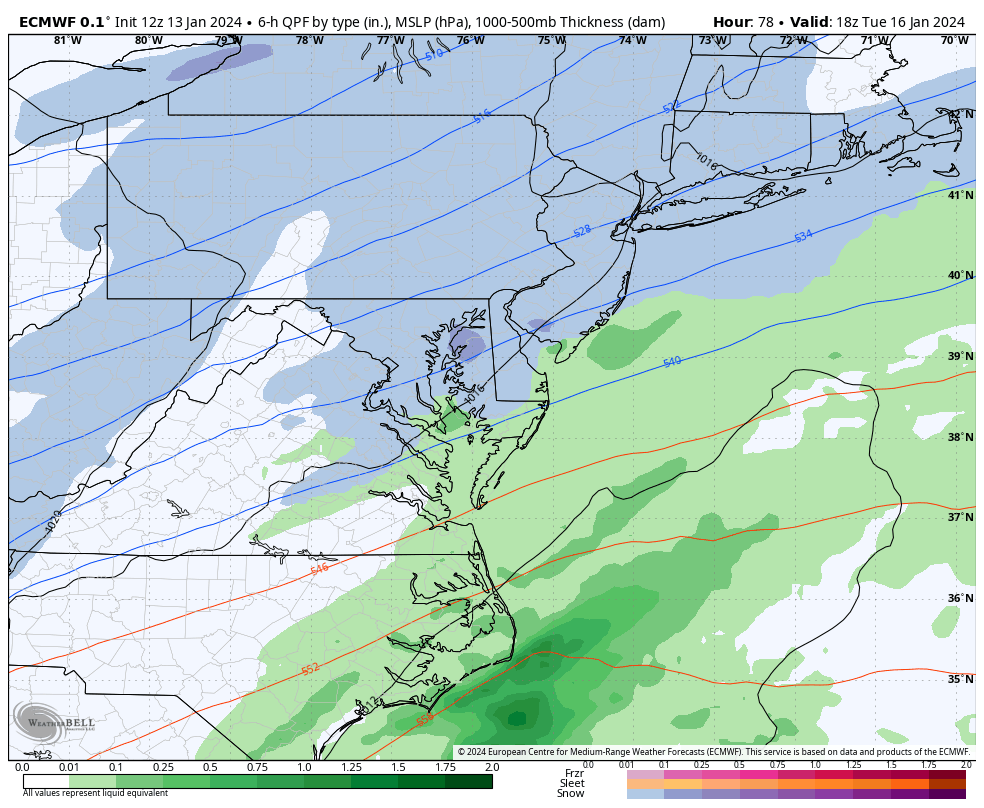
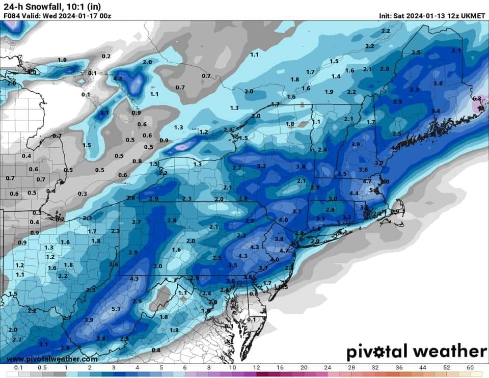
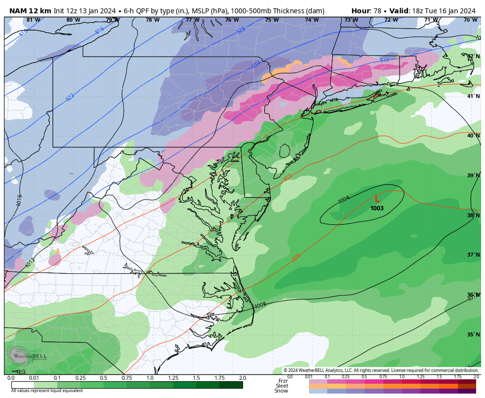
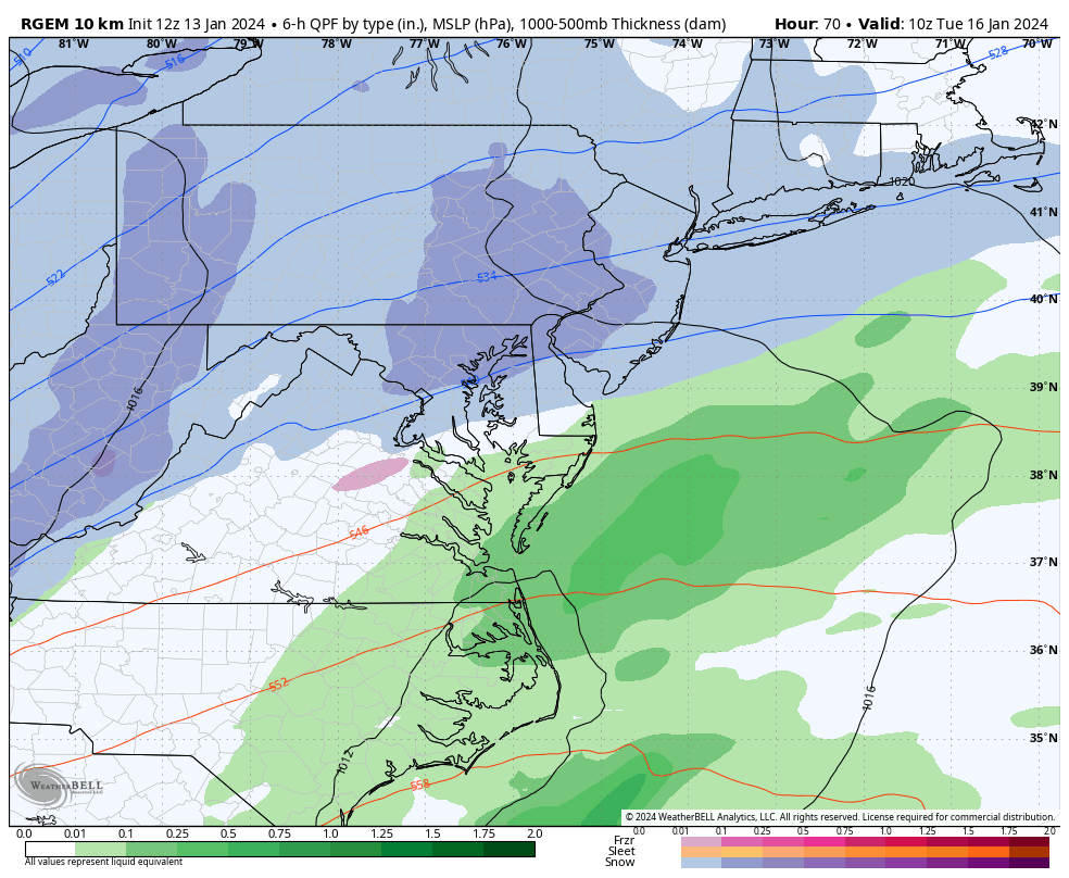
The three longer-range bigs (GFS, Canadian, and Euro) are continuing to suggest only a light snow event for Tuesday into Wednesday. The only longer-range model showing a more significant snowstorm is the UK Met (UKIE). The shorter-range NAM and RGEM are more amped…NAM amped to a total warm situation and the RGEM amped to a snow-to-rain situation. I am losing confidence in a big event for Tuesday-Wednesday. However, I am gaining confidence in a light-to-maybe-plowable event across all of NJ, possibly only for CNJ/SNJ. We’re going to have a storm (low developing offshore). We’re going to have cold air in place. Models are almost unanimous in at least delivering region-wide snow showers. I think there is still hope for something a little stronger given all the players on the field. However, the bigger event is likely off the table for Tuesday-Wednesday given the cold air invasion and the suppression this has on the storm track and developing low. Tonight’s model runs will be the last suite where I am just watching and discussing this as a possibility. Tomorrow’s 12Z model suite will confirm/determine our official forecast (first call) which will go out publicly at 5pm tomorrow (around 2pm in here). Here is some of the 12Z model guidance from today which supports my general stance:
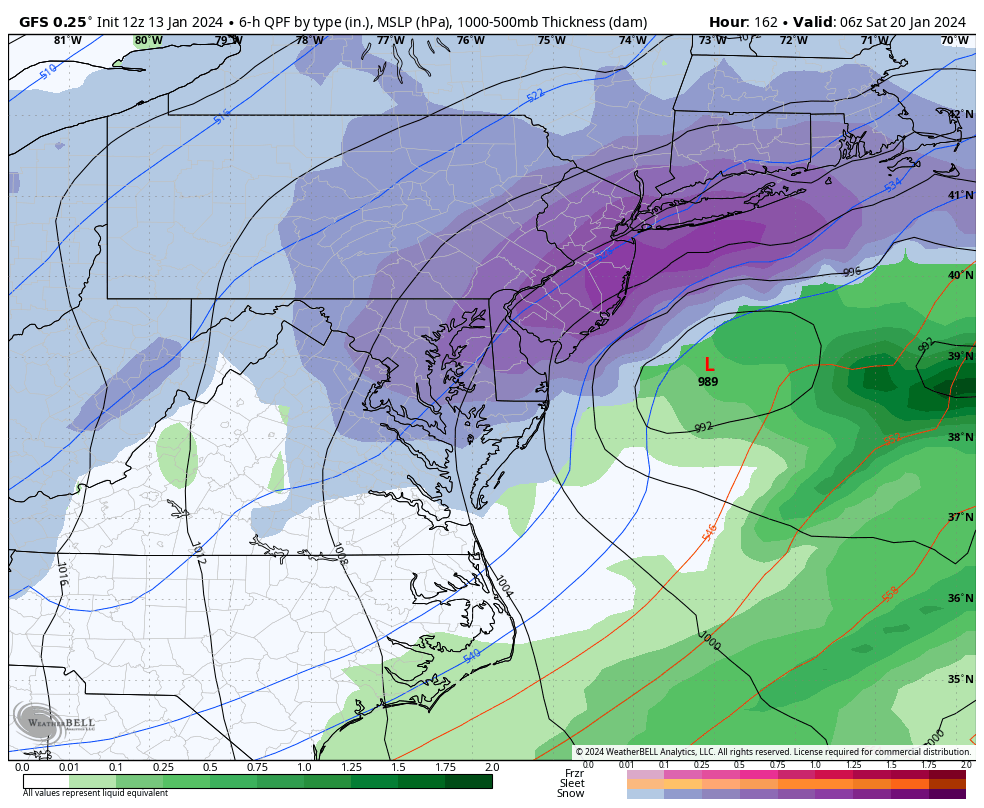
The next signal I am watching is Friday-Saturday (Jan 19-20). This system will occur towards the end of our colder pattern, not towards the front of it like Tues-Wed. There should be less suppression involved but it will all come down to the exact low track and placement which should be known by Wednesday. In the meantime, the GFS decided to bury NJ on Friday-Saturday with today’s 122Z run. The Euro and Canadian have something but not as intense as the GFS:
In English: It’s getting colder right now. It’s going to get much colder tomorrow (Sunday) with snow showers/squalls possible between 9am and 1pm. It then gets real cold Sunday night through Monday into Tuesday. For Tuesday-Wednesday, anything is possible at this point from just snow showers to a light/plowable event. A bigger snowstorm is likely off the table for Tues-Wed. Another snow signal exists not too far after on Friday-Saturday (Jan 19-20). So, the colder winter pattern begins today and ends Jan 22. And we have two snow possibilities to watch, this Tuesday-Wednesday and then Friday-Saturday. Our official first call on Tues-Wed will be out tomorrow at 5pm. Model runs tonight and tomorrow will be critical in shaping the forecast now that energy is becoming properly sampled. Today is the last day of “just watching and discussing.” Have a great rest of your day and please be safe! JC
Premium Services
KABOOM Club offers inside info forecast discussion, your questions answered, and early storm impact maps (ahead of the public). At a buck per month, it’s an extremely feasible way to show support.
My Pocket Meteorologist (MPM), in partnership with EPAWA Weather Consulting, offers professional/commercial interests, whose businesses depend on outdoor weather conditions (snow plowing, landscaping, construction, etc.), with hyper-local text message alerts/forecasts and access to the MPM premium forum—the most comprehensive and technical forecast discussion available for PA and NJ.
Get your KABOOM Inside Out pajamas and more at the KABOOM shop!
Jonathan Carr (JC) is the founder and sole operator of Weather NJ, New Jersey’s largest independent weather reporting agency. Since 2010, Jonathan has provided weather safety discussion and forecasting services for New Jersey and surrounding areas through the web and social media. Originally branded as Severe NJ Weather (before 2014), Weather NJ is proud to bring you accurate and responsible forecast discussion ahead of high-stakes weather scenarios that impact this great garden state of ours. All Weather. All New Jersey.™ Be safe! JC


LOCAL FORECAST | INTERACTIVE RADAR | LATEST NJ WEATHER ALERTS | WEDDING FORECAST| PRIVACY POLICY
© Copyright 2026 Weather NJ LLC. All Rights Reserved.
Some information that can be found on our website is provided by a private weather station and is not an officially recognized station for weather reporting. Though we always strive to achieve accurate reporting for our own use, it is important that you do NOT depend on the data provided here for any purpose.
