

Weather NJ Shares Stage with NWS & OEM
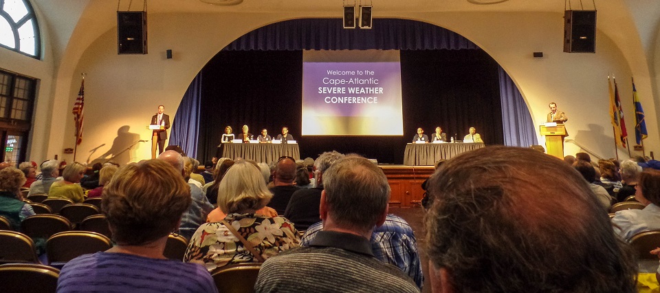
Last Thursday night I was invited to sit on a panel with National Weather Service personnel, professional meteorologists and several OEM authorities to talk about hurricane safety, preparation and public communication. The event was titled the Cape-Atlantic Severe Weather Conference and featured the following panel members:
Moderator Frank Donato, Ocean City’s Office of Emergency Management
Kathy Orr, FOX29 Philadelphia’s News Meteorologist
Dan Skeldon, Press of Atlantic City and Longport Media Meteorologist
Joe Miketta, National Weather Service Meteorologist in Mount Holly, NJ
Jim Eberwine, Retired National Weather Service Meteorologist
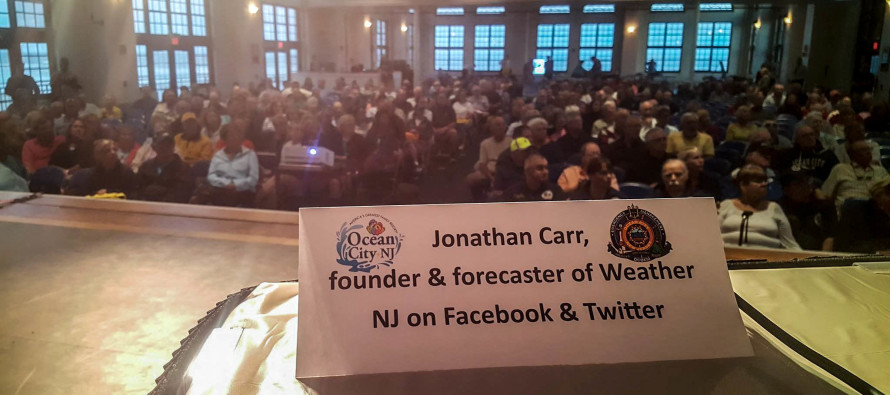
Jonathan Carr, Weather NJ Founder and Lead Forecaster
Martin Pagliughi, Cape May County Emergency Management Director
Vince Jones, Atlantic County Emergency Management Director
Vince Maione, Atlantic City Electric Region President
To be honest, I thought I was walking into the spot-lit crossfire of disgruntled beachgoers and shore business owners who faced hardship from a missed (busted) Labor Day Weekend Hurricane Hermine forecast. I also felt out of place being the only amateur weather enthusiast chosen for the panel. I was curious if some would ask what I’m even doing there. Instead I was met with overwhelming support and gratitude from a community who understands that erring on the side of caution is the smartest thing to do—people who have tremendous appreciation for the public service I provide.
When we look back at storm systems that hit the Jersey shore in 1821, 1903, 1944, 1962, 1985, 1993, 2011, 2012 and 2016, it’s not hard to imagine why people should/would evacuate when similar storm systems of such destructive nature are anticipated or expected. Up until about 24 hours before Hermine was supposed to hit, the best computer-simulated/modeled data on the planet as well as live observations in the atmosphere were suggesting another Jersey shore storm for the history books.
Due to a late 500mb (upper-level) low capture, Hermine ejected wide-right off the coast of the Outer Banks in North Carolina. By the time Hermine curved back towards the US East Coast, it had exhausted all of it’s energy after stacking beneath the center of the late-forming upper-level low. By the time Hermine was just off our coast, it had transitioned to just a normal mid-latitude cyclone in the occluding end-phase of its life cycle. The Jersey shore saw only a bit of rain along the immediate coast, a few gusty winds out of the north and minor coastal flooding. Had the capture happened on-time, New Jersey could have seen prolonged hurricane-force conditions which would have flirted with historical flooding records.
I’m amazed at how many conference attendees were thankful for the miss. Going into the storm system I was confused and even frustrated by the apparent complacency surrounding the potential impact. It turns out that more were listening than I thought as many did in-fact voluntarily evacuate and surrender their weekend at the shore. If this were a winter snow storm, there would have been serious disappointment and anger. But unlike quick recoverable school-closing blizzards, nobody really wishes for the destruction a hurricane brings.
 From left to right: Moderator OEM Frank Donato, FOX29 Meteorologist Kathy Orr, retired NWS Jim Eberwine,
NWS Meteorologist Joe Miketta and Weather NJ Founder and Lead Forecaster Jonathan Carr
Some very good questions were asked by the public and some very good answers were given by the panel. One thing that jumped out at me was the blatant expression of under-funding from the National Weather Service. If more marine buoys/stations were present in the Atlantic Ocean just off the Mid-Atlantic US, the NWS claims that coastal storm accuracy would improve tremendously. These buoys, which feed the models with live observational data and according to NWS meteorologist and panel guest Joseph Miketta, cost about a million dollars and require up to $2 million in maintenance for years after. There are numerous inshore buoys but only one offshore buoy that the National Weather Service at Mount Holly, NJ claims access to within their marine coverage area. So for the price of a single extravagant oceanfront house, we could get two more buoys out there that would make a huge difference in forecasting capability. These buoys could deliver crucial information for the hundreds of billions worth of shore-front property that spans the Jersey Shore. Amazing, right?
In addition, there was agreement in a general change in forecasting methods. Dan Skeldon agreed with me that a little education can go a long way when presenting a potentially dangerous situation. Instead of making an “all eggs in one basket” forecast when probability is below 100%, wouldn’t it be best to present all different possibilities on the table should any wildcard live observations occur (like a missed capture)? That way the public knows the possible severity but also how the forecast could go wrong well in-advance. Instead of hanging on the every breath of a forecaster, people can know what to look for (for example: capture vs no capture) and the community as a whole could enhance our collective situational awareness as human beings.
Many Weather NJ followers as well as panel hosts came up to me and expressed great thanks for attending the panel. I found the experience very refreshing, as if everyone walked out of the Music Pier in Ocean City with a handshake and a smile—as if everyone was already determined to communicate better with the National Weather Service, offices of emergency management, township authorities and professional forecasters the next time a major storm system approaches. If this truly was achieved then the panel event was worth its weight in gold. Unfortunately, the next major coastal New Jersey storm system is never more than a 4-7 day forecasting period away—any time of year. It’s obviously still yet to be determined if what was discussed at this event will have as much bite as it did bark. I AM hopeful though.
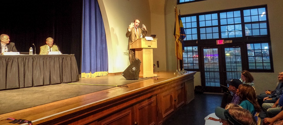 Press of Atlantic City Meteorologist Dan Skeldon addressing the audience
So next time a major coastal storm approaches the area, the public will be presented with possibilities and probabilities well in-advance with an understanding of what to look for with regard to the potential outcome. This will make us better as a whole. While it may shift some decision-making slightly into the hands of the public, there will be no shortage of long-range heads-up discussion for what possibly could happen. That’s our jobs as forecasters—to make the public aware with our best prediction while working with an incomplete data set. We certainly do not work with finite data like most who claim “I wish I was a meteorologist so I could get paid for being wrong.” Your accountant will be right every time when you bring him or her your pre-filled tax documents to file. Ask them to predict your future return next year and it’s a completely different ball game. Job raises, decreases in pay, sick leave, bonuses, etc. are all wrenches that can get thrown into the predictive outcome. That’s the best real-world analogy I can make to weather forecasting. The sooner everyone understands that, the better off we all will be.
The full video live-cast can be viewed here.
A HUGE hat tip to Dan Skeldon (@ACPressSkeldon) for inviting me to this panel. It was an absolute honor and privilege to sit next to the professionals in such a public-facing spotlight. I’m looking forward to any other opportunities like this that might arise in the future. It is simply great for the community. Have a great day and please be safe! JC
Jonathan Carr (JC) is the founder and sole operator of Weather NJ, New Jersey’s largest independent weather reporting agency. Since 2010, Jonathan has provided weather safety discussion and forecasting services for New Jersey and surrounding areas through the web and social media. Originally branded as Severe NJ Weather (before 2014), Weather NJ is proud to bring you accurate and responsible forecast discussion ahead of high-stakes weather scenarios that impact this great garden state of ours. All Weather. All New Jersey.™ Be safe! JC


LOCAL FORECAST | INTERACTIVE RADAR | LATEST NJ WEATHER ALERTS | WEDDING FORECAST| PRIVACY POLICY
© Copyright 2026 Weather NJ LLC. All Rights Reserved.
Some information that can be found on our website is provided by a private weather station and is not an officially recognized station for weather reporting. Though we always strive to achieve accurate reporting for our own use, it is important that you do NOT depend on the data provided here for any purpose.
