

Wednesday Snow a Go in NJ
Discussion: As expected, we’re warm, cloudy, and breezy out of the S/SE today. We’ll stay this way until rain pushes through, from NW to SE, later tonight into tomorrow morning. Behind this rain will be colder conditions with stiff winds out of the W/NW. This should prevent Tuesday from escaping the 30s in most places. Then all of NJ likely drops to freezing or below Tuesday night into Wednesday morning.
Wednesday’s system has evolved into two streams of energy, per today’s model analysis and live observation, a northern and southern branch. The N branch would likely provide snow through the Poconos into NY State. The southern branch would target SNJ/SENJ with heavier snow falling but possibly on a slightly above freezing surface during daylight hours. I say would because we still have room (at least 36 hours) for short range models and live obs to make small adjustments in energy tracks aloft and sfc low track. If we feel necessary, we’ll issue an updated forecast and snow map tomorrow before real-time tracking begins tomorrow night.
But the general trend over the last 48 hours has moved the best snow chances on Wednesday further S into SNJ/SENJ. NNJ and some of CNJ actually might miss out and only see flurries/light snow at times with little accumulation. Extreme NWNJ could behave similar from the N stream energy. Could models adjust backwards and show CNJ in the jackpot tomorrow? Sure, I’ve seen it many times. Since the low track is a direct function of latitude and what it means for NJ snow-wise, we could see more vertical adjustments in jackpot axis tomorrow into tomorrow night as the system makes its final NJ approach.
Right now most models are leaning towards our forecast (please see below snow map). All expect the Euro. The Euro has more influence from the N stream and very little influence from the S stream. Since it took baby steps (but not enough) towards the other model consensus, we will consider it an outlier for our initial forecast here.
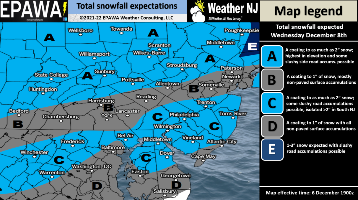
Full-resolution version of snow map!
In English: Warm, cloudy, and breezy until rain pushes through tonight. Colder tomorrow then snow on Wednesday. The event is light (see above snow map). We’ll adjust tomorrow if needed but this is where we stand for now. Be safe! JC
Download the free Weather NJ mobile app on Apple or Android. It’s the easiest way to never miss Weather NJ content. Our premium services go even further above and beyond at the hyper-local level.
Jonathan Carr (JC) is the founder and sole operator of Weather NJ, New Jersey’s largest independent weather reporting agency. Since 2010, Jonathan has provided weather safety discussion and forecasting services for New Jersey and surrounding areas through the web and social media. Originally branded as Severe NJ Weather (before 2014), Weather NJ is proud to bring you accurate and responsible forecast discussion ahead of high-stakes weather scenarios that impact this great garden state of ours. All Weather. All New Jersey.™ Be safe! JC


LOCAL FORECAST | INTERACTIVE RADAR | LATEST NJ WEATHER ALERTS | WEDDING FORECAST| PRIVACY POLICY
© Copyright 2026 Weather NJ LLC. All Rights Reserved.
Some information that can be found on our website is provided by a private weather station and is not an officially recognized station for weather reporting. Though we always strive to achieve accurate reporting for our own use, it is important that you do NOT depend on the data provided here for any purpose.
