

Wednesday Snow Map and Outlook (Feb 6-9)
Click here for full-resolution impact map!
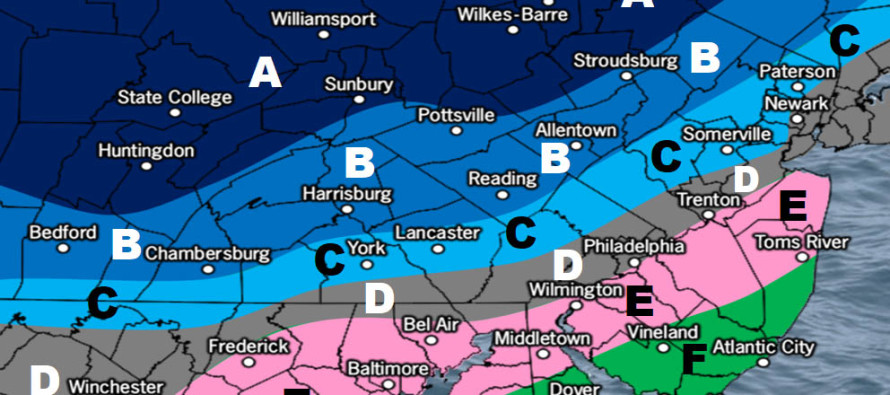
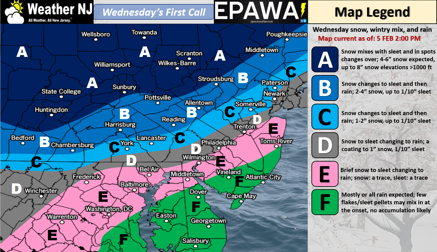
Discussion: A weak area of low pressure should ride a frontal boundary through SEPA and the NYC area between Wednesday afternoon and evening. This should bring area-wide precipitation. Those along and NW of I-95 have the best chance for an initial thump of snow before changing over to sleet and then ultimately rain. Precipitation could start as a snow/sleet/rain mix to the SE of I-95 but should go over to rain much quicker than those along and especially NW of I-95. This idea forms the foundation of our first-call impact map above…another snow to sleet to rain situation like yesterday (Sunday). I see two potential icy concerns. The first happens on Wednesday afternoon-evening when front-end snow will be changing to rain in the low-mid levels. If the surface is still at or below freezing then we’re looking at freezing rain. Right now, CNJ/NENJ are most favored for this but I would say anyone N of I-195 should look out for it. The second occurs later Wednesday night into Thursday morning after precipitation has ended. Temperatures will be dipping back below freezing statewide by ~2-3AM Thursday morning. Therefore any surface moisture that hasn’t evaporated will likely freeze for areas like SEPA, NENJ, CNJ and SNJ. Extreme SENJ will likely escape this threat but I could see problems away from the ocean, closer to I-95. We’re watching these possibilities closely and will be able to speak to them with more detail in our final call. The final call will be issued tomorrow and will feature any necessary adjustments. Premium MPM text alerts were sent out earlier today and we’ve been analyzing real-time model output for a few days now in the premium MPM forum.
Real quick: Expect another cold overnight tonight with lows bottoming out in the teens for most (upper-single digits for NWNJ elevations and lower-20s for SENJ coast). Overnight skies should range from partly-to-mostly cloudy by morning.
Tuesday (Feb 6) high temperatures should range from mid-30s to low-40s NNJ to SNJ. Skies should transition from mostly-cloudy to partly-cloudy. A small chance of passing snow showers exists mainly for NNJ (N of I-195) in the morning. I would expect most of whatever falls to stick given the colder overnight temperatures. Winds should be light out of the SW. Overnight lows should range from teens to 20s NNJ to SNJ.
Wednesday (Feb 7) high temperatures should range dramatically from near-freezing to near-50 NNJ to SNJ. Skies should be mostly cloudy with wintry precipitation possible, especially along and NW of I-95 (see above impact map for more details). Watch out for freezing rain as snow converts to possibly sleet before ultimately rain. If the ground is still 32F or below after the changeover then conditions could become much more hazardous for travel. Winds should be out of the S/SE statewide, calmer for NWNJ and breezier for SENJ. Overnight lows should fall back into the 20s for most. Watch out for leftover ground moisture freezing up!
Thursday (Feb 8) high temperatures should range from upper-20s to mid-30s NNJ to SNJ. Skies could start with an AM cloud deck but should give way to clearing by noon. Please watch out for icy roads! Any water leftover on the ground from Wednesday night’s system could present hazardous travel for Thursday morning’s commute. There will be more about this on tomorrow’s final call. Winds should be breezy, possibly gusty at times, out of the NW. Overnight lows should range from single-digits to near-20 NNJ to SNJ.
Friday (Feb 9) high temperatures should range from upper-20s to near-40 NNJ to SNJ. Skies could start partly cloudy but should increase in cloud coverage by PM hours. Winds should be light out of the SW. Overnight lows should range from mid-20s to mid-30s NNJ to SNJ.
An early look at the weekend indicates milder temperatures, decent cloud coverage and rain. Right now 40s and cloudy for Saturday and then 50s with rain for Sunday. Let’s take another look in a few days. Beyond this weekend the continued pattern of cold and dry to mild and wet should continue. If the cold and wet time-up right then we’ll be looking at a snow storm. Otherwise no major snow storms are currently on the table. Have a great rest of your week and please be safe! JC
For comprehensive and interactive hyper-local analysis that goes way above and beyond the detail of this public forecast, check out our premium services which include text notifications and forum access.
Jonathan Carr (JC) is the founder and sole operator of Weather NJ, New Jersey’s largest independent weather reporting agency. Since 2010, Jonathan has provided weather safety discussion and forecasting services for New Jersey and surrounding areas through the web and social media. Originally branded as Severe NJ Weather (before 2014), Weather NJ is proud to bring you accurate and responsible forecast discussion ahead of high-stakes weather scenarios that impact this great garden state of ours. All Weather. All New Jersey.™ Be safe! JC


LOCAL FORECAST | INTERACTIVE RADAR | LATEST NJ WEATHER ALERTS | WEDDING FORECAST| PRIVACY POLICY
© Copyright 2025 Weather NJ LLC. All Rights Reserved.
Some information that can be found on our website is provided by a private weather station and is not an officially recognized station for weather reporting. Though we always strive to achieve accurate reporting for our own use, it is important that you do NOT depend on the data provided here for any purpose.

)