

Wednesday Snow Targeting NNJ before Rain
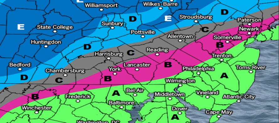
Discussion: There’s a tremendous amount of model disagreement with now less than 24 hours before the start of precipitation. Most of it revolves around how far SE the extent of snow will be in New Jersey. The overall consensus is not as far SE as projected yesterday. This would likely take 95 out of the equation to see a sloppy coating or even initial flakes and would likely mean all rain for 95 and points S and E of such. Most areas of NJ to the NW of 95 would also be lowered slightly. But still a decent light snow thump across NNJ in general with 1-3/2-4 still possible. We could define that as N of I-78 and NW of I-287.
There’s a few wildcard factors that worry me slightly. One is dry air in the 750-850mb layer as initial precipitation moves in. This could possibly rob from the initial snow thump. Also, the environment is very marginal, especially at some of the low-mid levels. This could mean more of a mixed precip type (sleet/snow) rather than a pure snow. These are wildcard factors that could play big with just a slight variation in low track or preceding high placement. For these reasons, there is high bust potential with tomorrow’s forecast. Here’s our updated snowfall projection prior to the changeover to rain for all areas (aside from extreme NWNJ):
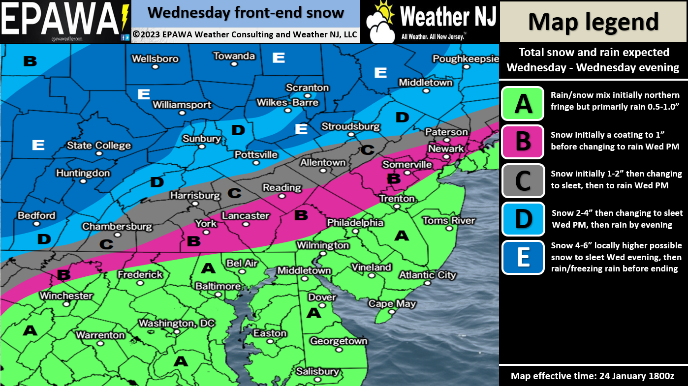
Click here for full-resolution snow map!
After this system moves out, we’ll be left in colder W/NW flow behind the departing low for this weekend. No Arctic cold source though just stale Canadian cold with mostly clear skies. Jan 31-Feb 8 continues to be the next synoptic storm signal window with Feb 2-4 slightly standing out. We’ll have a temporary more favorable environment for snow storm development and colder air available but still not an ideal pattern. Looks like a few Miller-A type possibilities. Let’s get through this system tomorrow and see how it affects anything for next week.
In English: Precipitation should move in tomorrow (Wednesday) from the W/SW between late-morning and early-afternoon. An immediate snow/rain line should set up likely near or just NW of 95 (Trenton to NYC). All areas to the S and E of this line will likely start as and stay all rain from start to finish. From about 2-6pm tomorrow the snow/rain line will likely advance northward and come to a rest for a few hours somewhere between I-80 and I-78 on the W side of NJ. On the E side of NJ, you can probably divide snow/rain at I-287. It will likely hold like this until about 9pm or so. After 9pm, the snow/rain line should then continue advancing all the way to the N of NJ. Outside of maybe the highest elevations of Sussex County (High Point Monument area), all of NJ should eventually change to rain ending by sunrise Thursday morning. The above snow map shows how much snow we think will fall across NNJ before the changeover to rain. The weekend then looks colder but nowhere near brutal. I am still watching the general Jan 31-Feb 8 period as at least 3 systems are expected to track up the coast in that period. Likely a final tweak to the forecast tomorrow morning ahead of initial precipitation. Otherwise have a great rest of your Tuesday and please be safe! JC
Premium Services
KABOOM Club offers inside info forecast discussion, your questions answered, and early storm impact maps (ahead of the public). At 99 cents per month, it’s an extremely feasible way to show support.
My Pocket Meteorologist (MPM), in partnership with EPAWA Weather Consulting, offers professional/commercial interests, whose businesses depend on outdoor weather conditions (snow plowing, landscaping, construction, etc.), with hyper-local text message alerts/forecasts and access to the MPM premium forum—the most comprehensive and technical forecast discussion available for PA and NJ.
Jonathan Carr (JC) is the founder and sole operator of Weather NJ, New Jersey’s largest independent weather reporting agency. Since 2010, Jonathan has provided weather safety discussion and forecasting services for New Jersey and surrounding areas through the web and social media. Originally branded as Severe NJ Weather (before 2014), Weather NJ is proud to bring you accurate and responsible forecast discussion ahead of high-stakes weather scenarios that impact this great garden state of ours. All Weather. All New Jersey.™ Be safe! JC


LOCAL FORECAST | INTERACTIVE RADAR | LATEST NJ WEATHER ALERTS | WEDDING FORECAST| PRIVACY POLICY
© Copyright 2026 Weather NJ LLC. All Rights Reserved.
Some information that can be found on our website is provided by a private weather station and is not an officially recognized station for weather reporting. Though we always strive to achieve accurate reporting for our own use, it is important that you do NOT depend on the data provided here for any purpose.
