

Weekend Rainstorm Detected
Discussion: Not much has changed from a few days ago in the weekly outlook. This weekend continues to look suboptimal for outdoor plans, especially coastal areas S and E of the turnpike. Let’s break it down:
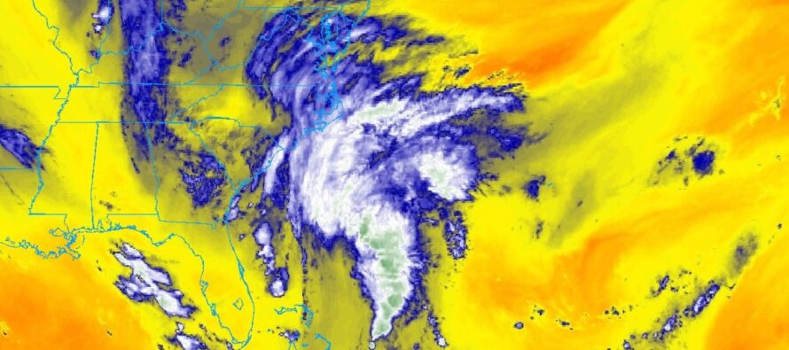
A tropical disturbance is currently (as of Thursday afternoon) trying to organize a few hundred miles offshore (East) of Florida (see above GOES Satellite Imagery). It’s unsure how strong the system will be, of tropical nature, when the center of circulation makes landfall somewhere in coastal NC early Saturday morning. It could become a weak named tropical storm or remain a depression. For now it has tropical depression stats and is identified by the NOAA National Hurricane Center as Potential Tropical Cyclone Sixteen. If it meets tropical storm criteria, it will be named Ophelia.
Regardless, the system should make landfall over coastal NC (likely S OBX) early Saturday morning. We have a departing area of high pressure correlating with a ridge that will provide the N/NW steering currents for the system in the mid-upper levels. It is around this time (early Saturday morning) that the precipitation shield should push into NJ from the S. I’m seeing a heavier rain during Saturday AM hours (ending around noon) before a piece of energy breaks off and departs westward from the remnant circulation Saturday afternoon-evening. This would likely mean a break in rain between Saturday noonish and later Saturday night, possibly Sunday morning. But given the onshore flow and cloud profiles, periods of mist could occur during the precipitation break.
The remnant center of circulation is then expected to push further N/NW into E VA/MD/E PA/SE PA and ultimately dissolve/slowly drift back E over NJ through Monday night, possibly Tuesday morning. SENJ is favored for precipitation for the Saturday AM rainfall. NWNJ is then favored for the rainfall Sunday through Tuesday morning. Most of NJ, however, is on the hook for at least 1.5 inches of widespread rainfall throughout the entire period (Saturday-Tuesday).
We’ve seen mild-to-moderate winds and periods of heavy rain before. Wind damage should be mild but the heavy downpours, especially Saturday AM, are capable of producing flash flooding. I am also watching the coastal flooding potential from this. Given the multiple day duration of this system and the prolonged onshore flow, we’ll have about 6-8 high tides to watch mainly between Friday and Monday. I expect most of the high tides to produce routine minor (small chance of moderate) coastal flooding. However, the Saturday high tide to occur just after noon, looks to peak with this strongest storm surge potential. This could produce moderate-to-major coastal flooding. Luckily, the lunar cycle will be at half-moon. Heavy rainfall, however, will struggle to drain into flooded estuaries/marshlands. I will revisit this concern in tomorrow’s weekend outlook.
In English: We’ve had a few amazing days of weather conditions and that should spill into some of Friday for most areas away from the ocean. Coastal areas on Friday should start to feel the winds picking up from the approaching rain system. That means another stellar Thursday night tonight. By Saturday morning, periods of moderate-to-heavy rainfall should push into at least SNJ/CNJ/NENJ. NWNJ is still yet TBD for the initial rain. A break in the heavier rain is then expected from about noon (maybe slightly after) on Saturday until later Saturday night or Sunday morning. It could still be windy, cloudy, and misty during this break. Periods of steadier rain are then expected to return from late Saturday night through possibly Tuesday morning. This second round of steadier rain should target NWNJ/NNJ/CNJ, not SNJ or SENJ. Again though, it could still be windy, misty, and cloudy. When all is said and done (Tuesday morning), most NJ areas should have seen at least 1.5 inches of rainfall. I wouldn’t be surprised to see some localized areas with 2-4 inches but not everywhere. Winds should be mild-to-moderate…persistent but nothing crazy…felt most along the ocean and least inland. Flash flooding (from periods of near-stationary heavy rainfall) and coastal flooding are becoming a concern, especially the Saturday high tide just after noon along immediate coastal areas of ECNJ/SENJ/SNJ. In summary, periods of rain, sustained E winds, and coastal flooding are expected Saturday morning through Tuesday morning. A bummer for outdoor activities but much needed for our land. Be safe! JC
Premium Services
KABOOM Club offers inside info forecast discussion, your questions answered, and early storm impact maps (ahead of the public). At 99 cents per month, it’s an extremely feasible way to show support.
My Pocket Meteorologist (MPM), in partnership with EPAWA Weather Consulting, offers professional/commercial interests, whose businesses depend on outdoor weather conditions (snow plowing, landscaping, construction, etc.), with hyper-local text message alerts/forecasts and access to the MPM premium forum—the most comprehensive and technical forecast discussion available for PA and NJ.
Jonathan Carr (JC) is the founder and sole operator of Weather NJ, New Jersey’s largest independent weather reporting agency. Since 2010, Jonathan has provided weather safety discussion and forecasting services for New Jersey and surrounding areas through the web and social media. Originally branded as Severe NJ Weather (before 2014), Weather NJ is proud to bring you accurate and responsible forecast discussion ahead of high-stakes weather scenarios that impact this great garden state of ours. All Weather. All New Jersey.™ Be safe! JC


LOCAL FORECAST | INTERACTIVE RADAR | LATEST NJ WEATHER ALERTS | WEDDING FORECAST| PRIVACY POLICY
© Copyright 2026 Weather NJ LLC. All Rights Reserved.
Some information that can be found on our website is provided by a private weather station and is not an officially recognized station for weather reporting. Though we always strive to achieve accurate reporting for our own use, it is important that you do NOT depend on the data provided here for any purpose.
