

Weekend Rainstorm Developing
Forecast Discussion: Not much has changed since the article earlier this week. We have another weekend rain event as the weekend rain pattern continues.
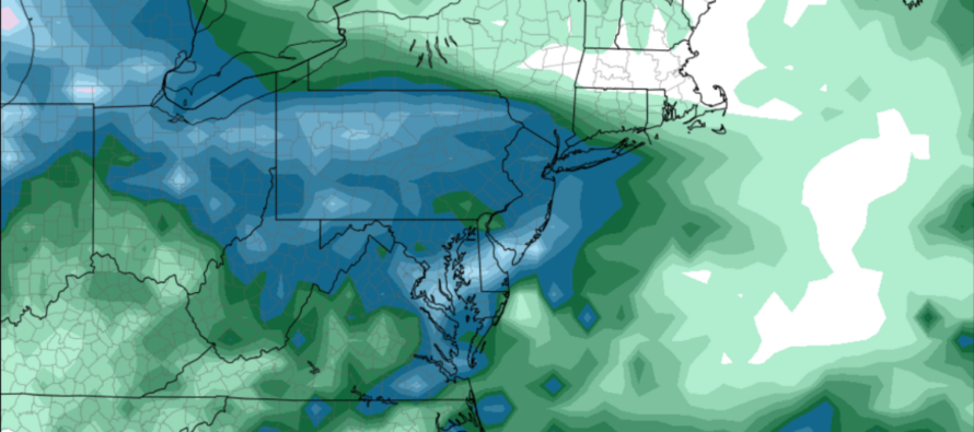
We have a Miller-B synoptic setup this weekend. A primary low (currently developing) will track from the N/C Plains towards the S Great Lakes between now and Saturday morning. It will then transfer to a secondary coastal low near/just S of the 40N/70W benchmark by Sunday morning. With that said, the primary low will introduce us to the rain and the secondary low will end it with a peak rainy transition occurring between. All of New Jersey is on the hook for 1-1.75 inches of rainfall in general. There could be isolated spots with slightly more or less.
This would be a fantastic synoptic snow setup if it were mid-winter with an appropriately cold temperature profile. The President’s Day Snowstorm of 2003 was a Miller-B with the secondary coastal storm stalling a bit before moving out. One thing to watch out for is the dry slot in precipitation during the transfer. Once the transfer occurs, precipitation near the former primary low tends to dissolve into nothing. Like a fart in the wind. It then concentrates around the secondary. This robbed many interior areas of snowfall in Feb 2003 and it could rob similar areas this weekend of rainfall. For this reasoning, SENJ is a little more favored for rainfall than NWNJ is.
I’m not seeing much thunderstorm activity as much of surface will be cooler (not terribly warmer than aloft) and therefore lacking the convective dynamic potential for such. However, let’s allow for a few embedded rumbles under areas of heaviest downpour. The primary low rain should arrive from the W/NW but once the coastal takes over, the rain and wind will move in from the NE.
Saturday might start with the sun still shining in a few spots but for the most part, I expect clouds to move in anytime after sunrise. It’s still highly uncertain as to the exact start time of rain on Saturday. NNJ theoretically should start raining before SNJ given the axis of precipitation coming in from the W/NW across EPA and NNJ. SNJ would then fill in shortly afterwards. I think it’s safe to say the rain starts by or around noon for NNJ and by afternoon for SNJ. It should then rain steady for most areas from Saturday afternoon through Sunday morning with ECNJ/SENJ rain ending last as the secondary coastal pulls away. I’m not seeing the winds pick up until the secondary coastal takes over and that’s really only for coastal ECNJ/SENJ to see later Saturday night into Sunday. I could see immediate coastal areas gusting in the 30-40mph range while areas away from the ocean fall into more of a “just breezy/kind of gusty” category.
A minor coastal flooding concern exists from late-Saturday night through Sunday as NE winds take over and push water into the coast of NJ. Peak storm surge should time with the high tide just before noon on Sunday. That should be the highest water levels of the event and again, likely only minor falling short of moderate.
This system should clear out by Sunday afternoon with conditions improving Sunday night into Monday. By late Monday night we could be looking at another rain event (coastal inverted trough situation) moving in for Tuesday.
In English: Magnificent fall weather conditions continue for the rest of today (Thursday) and tomorrow (Friday). Clouds then move in later Friday night/Saturday morning and then rain by noon-ish Saturday for much of NJ, maybe a little earlier for NNJ/a little later for SNJ. But expect steady rainfall, possibly heavy at times, between Saturday afternoon and late-Sunday morning. Rain should gradually taper off from late-Sunday morning through Sunday afternoon (NWNJ clears first – SENJ clears last – NENJ/SWNJ clears somewhere between from NW to SE). Expect 1-1.75 inches of rainfall total (locally higher or lower) with isolated/embedded thunderstorms possible at times. Winds should become breezy for most NJ areas by Saturday night, possibly gusty (30-40mph) for the ECNJ/SENJ immediate coast overnight into Sunday. Minor coastal flooding is possible on Sunday, mainly during high tide just before noon. Conditions improve for Sunday afternoon/evening into Monday morning with more rain possible Monday night through Tuesday. Have a great rest of your Thursday and please be safe! JC
Premium Services
KABOOM Club offers inside info forecast discussion, your questions answered, and early storm impact maps (ahead of the public). At 99 cents per month, it’s an extremely feasible way to show support.
My Pocket Meteorologist (MPM), in partnership with EPAWA Weather Consulting, offers professional/commercial interests, whose businesses depend on outdoor weather conditions (snow plowing, landscaping, construction, etc.), with hyper-local text message alerts/forecasts and access to the MPM premium forum—the most comprehensive and technical forecast discussion available for PA and NJ.
Jonathan Carr (JC) is the founder and sole operator of Weather NJ, New Jersey’s largest independent weather reporting agency. Since 2010, Jonathan has provided weather safety discussion and forecasting services for New Jersey and surrounding areas through the web and social media. Originally branded as Severe NJ Weather (before 2014), Weather NJ is proud to bring you accurate and responsible forecast discussion ahead of high-stakes weather scenarios that impact this great garden state of ours. All Weather. All New Jersey.™ Be safe! JC


LOCAL FORECAST | INTERACTIVE RADAR | LATEST NJ WEATHER ALERTS | WEDDING FORECAST| PRIVACY POLICY
© Copyright 2026 Weather NJ LLC. All Rights Reserved.
Some information that can be found on our website is provided by a private weather station and is not an officially recognized station for weather reporting. Though we always strive to achieve accurate reporting for our own use, it is important that you do NOT depend on the data provided here for any purpose.
