

Weekend Rainstorm Update
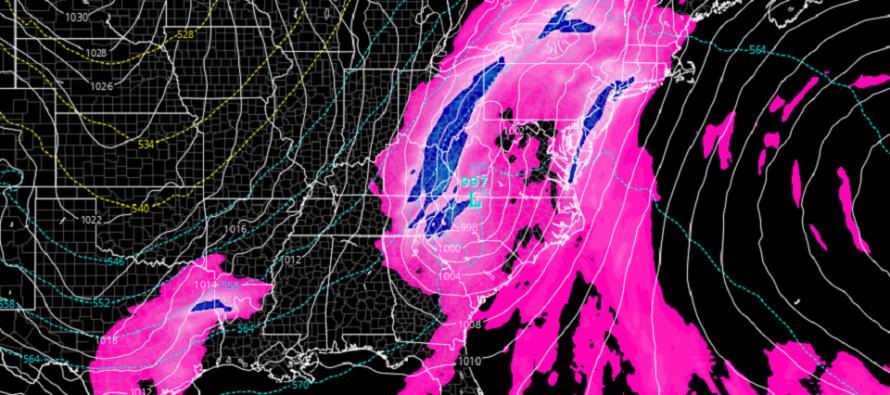
Discussion: Our cool streak (since Monday night’s cold front) is about to end as we roller coaster forward with temperatures again. High pressure is drifting out to sea and Nicole will make landfall in E FL before tracking N through the E US. This will place NJ in the way of S flow between the high and low from Thursday into Saturday—as Nicole ultimately tracks to the W and N of NJ. We’re probably looking at 60s Thursday and near-70 Friday and Saturday (peak warm sector flow + rainstorm) before crashing hard with Sunday morning’s cold front.
Rain looks to start on Friday by early afternoon, possibly by late-morning. Rain should then fall on and off through the rest of Friday PM and taper off from W to E on Saturday morning. Rainfall totals are still expected in the half-inch to two-inch range with NWNJ favored for the higher of the range and SENJ favored for the lower of the range. Still not seeing any concerns for tornadoes, severe thunderstorms, or coastal flooding (due to wind direction and tidal orientation). Conditions should then improve for Saturday…still somewhat mild but clear and becoming breezy into Saturday night. The bottom then drops out Sunday morning with the cold front. Again, most of NJ failing to escape the 40s Sunday. Sunday night lows dipping below freezing for many away from the immediate coast with NW winds dominating.
Next week is still looking cold. More like December than November. I still think its possible that New Jersey could see first snowflakes sometime between this Sunday night and next weekend. There are lake effect opportunities and near-tracking coastal low signals I am watching that could make this happen. It’s kind of a stretch, wouldn’t get hopes too high, but I’ve seen stranger setups. I’ll report more on this after we get closer/deal with Nicole’s remnants.
As far as Nicole goes, it’s hitting the N Bahamas today (Wednesday) and should make landfall near ~West Palm, FL either late tonight or early tomorrow morning. It could reach category 1 hurricane status (currently a strong Tropical Storm) before FL landfall and produce heavy rain, high winds, and hazardous surge for W Palm and coastal areas N of such. Nicole will then track across FL to the NW. By tomorrow evening (Thursday), Nicole should be nearing the FL Panhandle and turning back towards the interior E US. Nicole will lose tropical core characteristics but the remnants will slide up the coast and bring the rain to New Jersey Friday-Saturday. The heavier rain from Nicole should stay to the W of NJ as the center of original circulation and strongest rain bands track up the Appalachian Mountains.
In English: Expect dry and milder conditions Thursday/Thursday night before rain moves in by noonish Friday. Rain should then be on-and-off, possibly heavy at times, between noon Friday and mid-to-late Saturday morning. Winds could be moderate at times but nothing crazy. Saturday/Saturday night doesn’t look too bad (after AM rain ends and before the cold moves in by Sunday morning). Sunday into next week then looks cold with first snowflake chances possible by end of next week. Have a great rest of your Wednesday and please be safe! JC
Premium Services
KABOOM Club offers inside info forecast discussion, your questions answered, and early storm impact maps (ahead of the public). At a buck per month, it’s an extremely feasible way to show support.
My Pocket Meteorologist (MPM), in partnership with EPAWA Weather Consulting, offers professional/commercial interests, whose businesses depend on outdoor weather conditions (snow plowing, landscaping, construction, etc.), with hyper-local text message alerts/forecasts and access to the MPM premium forum—the most comprehensive and technical forecast discussion available for PA and NJ.
Jonathan Carr (JC) is the founder and sole operator of Weather NJ, New Jersey’s largest independent weather reporting agency. Since 2010, Jonathan has provided weather safety discussion and forecasting services for New Jersey and surrounding areas through the web and social media. Originally branded as Severe NJ Weather (before 2014), Weather NJ is proud to bring you accurate and responsible forecast discussion ahead of high-stakes weather scenarios that impact this great garden state of ours. All Weather. All New Jersey.™ Be safe! JC


LOCAL FORECAST | INTERACTIVE RADAR | LATEST NJ WEATHER ALERTS | WEDDING FORECAST| PRIVACY POLICY
© Copyright 2026 Weather NJ LLC. All Rights Reserved.
Some information that can be found on our website is provided by a private weather station and is not an officially recognized station for weather reporting. Though we always strive to achieve accurate reporting for our own use, it is important that you do NOT depend on the data provided here for any purpose.
