

Weekend Snow Approaching
Discussion: The “two snow systems in one weekend” idea has gained legs. For the first time all week, we have a slightly increased confidence in how the weekend will play out. The model data has converged towards the following solution.
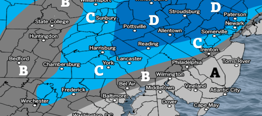
An Arctic cold front will push through the Mid-Atlantic US between late tonight (Friday) and mid-to-late tomorrow morning (Saturday). As the Arctic cold front pushes through PA and NJ, a weak upper-level shortwave will ride the front and generate additional lifting. This lifting should produce snow showers primarily for areas of NJ N of I-78 between midnight and 10am Saturday. Though the window for the main batch of snow begins at midnight tonight, you might see some initial snow showers develop earlier tonight/this evening. Snow showers should then taper off completely by noon on Saturday and we see a break (cold air mass – cold Saturday night) until Sunday morning as the frontal boundary moves offshore. A weak coastal low should then form a few hundred miles off OBX Sunday morning and ride the offshore boundary to its NE towards Nova Scotia/Newfoundland, producing/sending in a 10am-10pm coastal snowfall for areas of NJ along and SE of the I-95/NJTP corridor. The Saturday morning snowfall is primarily targeting NNJ (N of I-78) and the Sunday snowfall is targeting SENJ. There could be a strip between (~between areas just SE of 95 and S of I-78) that gets skunked from both systems.
Neither system is a major snow event but either one could become a plowable light-to-significant snowfall. 6 inches is probably the absolute max upside potential for either or but here’s the catch, the Saturday system affects the Sunday system. If Saturday’s Arctic front/shortwave is stronger and more aggressive (higher snowfall totals), then the boundary will come to rest further out in the Atlantic Ocean. This would mean the Sunday coastal low tracks further out to sea and just grazes SENJ, possibly missing completely. However, if the Saturday morning system is weaker and produces, say only a coating to a few inches, then that means the boundary will come to rest closer to the east coast and the coastal low on Sunday will track closer, increasing SENJ snowfall totals all the way into I-95/NJTP. So with this IF THEN/OR ELSE scenario, we have made two snow maps. The first map contains expected snowfall amounts for Saturday morning. The second map is for Sunday and is probabilistic based. Tomorrow, we’ll be able to make a much more confident map for Sunday once we see the extent of Saturday’s NNJ snowfall outcome. With that said, this is where we are:
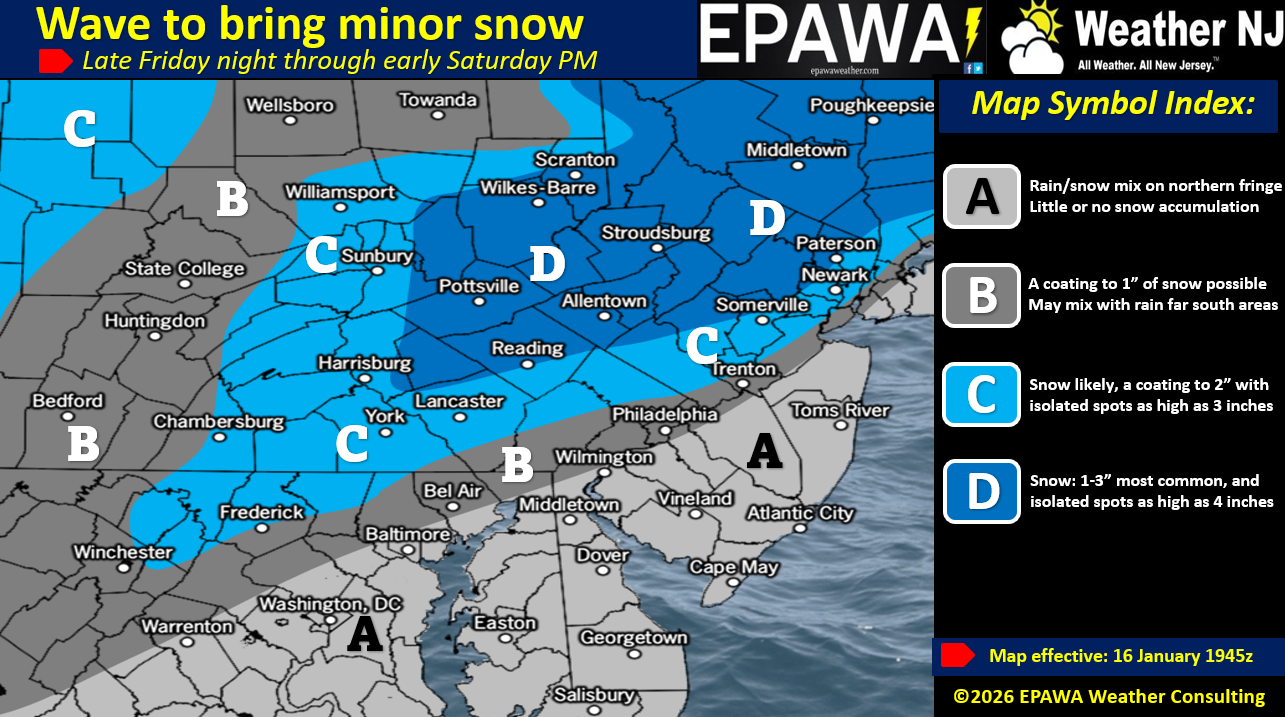
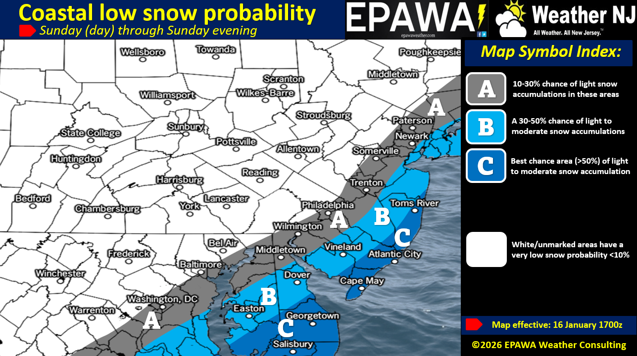
In English: Snow is possible Saturday morning (~midnight to ~10am for the main NJ batch – could start earlier this evening/tonight) and Sunday (~10am to ~10pm). NNJ is most targeted for Saturday morning and SENJ is most targeted for Sunday. Areas between I-78 and I-95/NJTP have the least chance for snow but could still see a little. Depending on how Saturday goes (little or more snowfall) will determine how Sunday goes. So above are two maps, a more certain one for Saturday morning and a probabilistic map for Sunday. Have a great rest of your Friday and please be safe! JC
Premium Services
KABOOM Club offers an ad-free environment, inside info (Above and Beyond) forecast discussion, your questions prioritized, and early storm impact maps and video releases (ahead of the public). At $1.99 per month, it’s an extremely feasible way to show additional support for Weather NJ and you can turn it on and off for however many months you wish. Think of it as a tip jar with perks. Available onFacebook or Patreon.
My Pocket Meteorologist (MPM), in partnership with EPAWA Weather Consulting, offers professional/commercial interests, whose businesses depend on outdoor weather conditions (snow plowing, landscaping, construction, etc.), with hyper-local text message alerts/forecasts from real meteorologists and access to the MPM premium forum—the most comprehensive and technical forecast discussion available for PA and NJ commercial interests.
KABOOM Shop is live if you want some KABOOM or Weather NJ Merch!
Sign up for ZoneWatch Radar and get 10% off
Jonathan Carr (JC) is the founder and sole operator of Weather NJ, New Jersey’s largest independent weather reporting agency. Since 2010, Jonathan has provided weather safety discussion and forecasting services for New Jersey and surrounding areas through the web and social media. Originally branded as Severe NJ Weather (before 2014), Weather NJ is proud to bring you accurate and responsible forecast discussion ahead of high-stakes weather scenarios that impact this great garden state of ours. All Weather. All New Jersey.™ Be safe! JC


LOCAL FORECAST | INTERACTIVE RADAR | LATEST NJ WEATHER ALERTS | WEDDING FORECAST| PRIVACY POLICY
© Copyright 2026 Weather NJ LLC. All Rights Reserved.
Some information that can be found on our website is provided by a private weather station and is not an officially recognized station for weather reporting. Though we always strive to achieve accurate reporting for our own use, it is important that you do NOT depend on the data provided here for any purpose.
