

Weekend Snow Chances Increasing
Discussion: The upper jet stream remains locked in the Montana down to MidWest US and over to the Mid-Atlantic US configuration…a zonal flow for the E US. High pressure and the surface reflection under a shortwave will squeeze moisture out of the atmosphere in a flat wave that follows this exact thermal gradient pathway to the coast this weekend.
A strong Arctic high will descend out of Canada into the MidWest US behind this wave and amplify the pattern into a temporary meridional look, forming a weak ridge in the W US and a positive tilted trough for the E US. As this happens, a weak coastal surface low will form under a jet streak off of Delmarva/OBX. The combination of all these forces will enhance the flat wave and precipitation along the thermal gradient just enough to deliver a light-to-moderate snow event for New Jersey this Sunday morning.
Today (Thursday), we had some lake effect streamers of flurries and snow showers pass over the Atlantic City Expressway from PHL to ACY. A testament of the arriving cold air and tonight will be a cold one. Friday and Saturday seem tranquil and settled but under the colder air mass. The coastal plain should reach well into the mid-to-upper 30s while areas NW of 95 struggle to break freezing. Temperatures will then drop Saturday evening/night with regular loss of sun and then the drop will accelerate with the precipitation arriving around midnight. It will be very cold aloft Saturday night/Sunday morning. 925, 850, and 700mb layers all well below freezing, so the precip will likely bring that down and chill the surface below freezing during early Sunday AM hours even the immediate coastal areas of the coastal plain. Depending on the exact axis of the wave, a widespread expectation of light snow accumulations is expected for New Jersey between midnight Saturday night and about 10am Sunday morning.
Within that midnight to 10am window of light snow accumulation exists the potential for snowfall to push into the moderate category via convective jet streak enhancement and/or the weak developing low offshore. These factors could be what takes just a few plowable inch expectation into something more moderate/significant, especially with higher snow ratios associated with the colder environment. This could happen in just a few isolated instances/locations, or it could happen at a larger scale across the state under larger banding. This is yet TBD and therefore why a plowable snowfall is the safest call from this point.
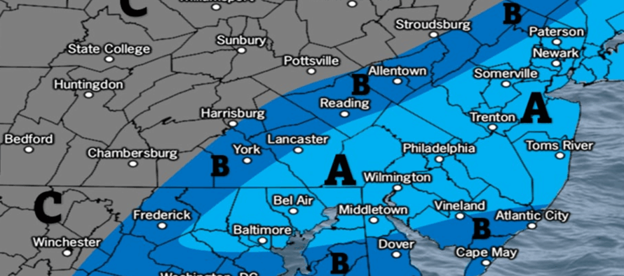
I’m really pulling for a statewide 2-4, iso 4+ situation for the entire state (not our official amount expectations just yet). This would be the ideal snow lover’s fruition and would allow for that hot chocolate holiday lights cruise Sunday evening. However, deviations in the fickle zonal nature of the wave could mean slight variation N to S. A little N and SNJ/SENJ gets robbed from air not able to cool enough at the surface via marine influence. A little S and only CNJ/SNJ gets the snow while NNJ, possibly some of CNJ gets skunked. We still need to iron out this part of it which is why today’s impact map (see below) is only in the form of a probabilities map. But for now, I’m leaning towards a plowable snowfall for much of NJ with the potential for something a little more between midnight Saturday night and 10am Sunday morning.
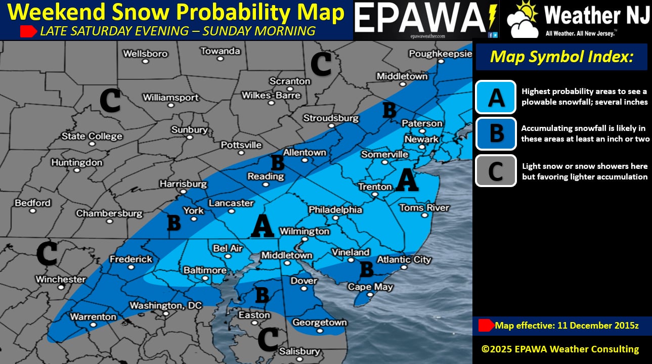
In English: Chances of snow this weekend (~midnight Saturday night to ~10am Sunday morning) are increasing. That’s the general timing from first to last flake. Actual time of accumulating snowfall likely shorter within that window. First snow map with details will happen tomorrow. But from this range, I’m thinking widespread plowable snowfall is a safe expectation with the potential for a little more in a jackpot zone (yet TBD within north-central and south-central Jersey). Have a great rest of your Thursday and please be safe! JC
Premium Services
KABOOM Club offers ad-free content, inside info forecast discussion, your questions answered, and early storm impact maps and video releases (ahead of the public). At $1.99 per month, it’s an extremely feasible way to show additional support for Weather NJ and you can turn it on and off for however many months you wish. Think of it as a tip jar with perks. Available onFacebook or Patreon.
My Pocket Meteorologist (MPM), in partnership with EPAWA Weather Consulting, offers professional/commercial interests, whose businesses depend on outdoor weather conditions (snow plowing, landscaping, construction, etc.), with hyper-local text message alerts/forecasts from real meteorologists and access to the MPM premium forum—the most comprehensive and technical forecast discussion available for PA and NJ.
KABOOM Shop is live if you want some KABOOM or Weather NJ Merch!
Jonathan Carr (JC) is the founder and sole operator of Weather NJ, New Jersey’s largest independent weather reporting agency. Since 2010, Jonathan has provided weather safety discussion and forecasting services for New Jersey and surrounding areas through the web and social media. Originally branded as Severe NJ Weather (before 2014), Weather NJ is proud to bring you accurate and responsible forecast discussion ahead of high-stakes weather scenarios that impact this great garden state of ours. All Weather. All New Jersey.™ Be safe! JC


LOCAL FORECAST | INTERACTIVE RADAR | LATEST NJ WEATHER ALERTS | WEDDING FORECAST| PRIVACY POLICY
© Copyright 2026 Weather NJ LLC. All Rights Reserved.
Some information that can be found on our website is provided by a private weather station and is not an officially recognized station for weather reporting. Though we always strive to achieve accurate reporting for our own use, it is important that you do NOT depend on the data provided here for any purpose.
