

Weekend Snow Detected
Discussion: Yesterday I was told by many that it couldn’t possibly snow in NNJ/CNJ last night because it was [insert temperature] degrees outside. Hopefully there is a better understanding now that “it is going to snow where it wants to snow.” A warmer surface can be cooled by heavy precipitation bringing down cold temperatures from aloft, especially overnight. Remember, your air temperature at the surface is different than temperatures above you. In this case there was adequate aloft cold to chill the warmer surface and allow as much as 4 inches to stick in some parts of NNJ. Roads saw less accumulation because concrete and asphalt retain heat longer than natural surfaces. But even so, I saw that a few roads needed plowing in NNJ. CNJ saw less and SNJ saw little-to-nothing as generally suspected. Onward we go.
Today, through tomorrow, and into Thursday morning should remain windy. We’re going to have a 950mb low S of Newfoundland and a 1044mb+ high in SC Canada parked for about 48 hours thanks in part to the Greenland block and 50/50 low influence. That’s a recipe for tight isobars running N to S for the E US and the reason why our winds will be out of the N or N/NW today and tomorrow. Expect sustained winds of 15-20mph with gusts to 30-35mph. Not so much an issue with high wind speed values, moreso with prolonged duration of moderate winds. Winds should then relax for later Thursday and Friday, keeping a colder air mass in place ahead of the expected Friday-Saturday system.
It is best to first focus on the Friday-Saturday system before putting any effort into the remainder of the favorable period for snow storm development (through about March 22). I have no doubt there will be several more snow threats in that period but the models are still struggling with the pattern change that far ahead and are producing some wild output. This Friday-Saturday has moved from the long-range to mid-range forecasting period. It’s now 4 days away and time for serious tracking.
The GFS, Euro, Canadian, and UKMET models are all in agreement on something wintry happening in New Jersey this Friday-Saturday. The pattern supports it but the exact details will be ironed out over the next few days. We know a lot more now than just yesterday or days before however.
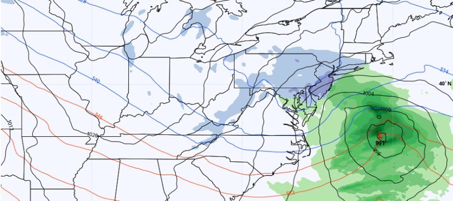
The general idea is a northern stream low that tracks across the N US/S Great Lakes Thursday and Friday. The low encounters the blocking pattern when it gets near Pittsburg, PA late Friday night and then transfers (Miller-B style) to a coastal low off S Delmarva early Saturday morning. The redeveloped coastal low then gets caught by the upper-low steering currents and tucks/hangs off the Jersey coast through Saturday afternoon. This allows additional wintry precipitation to fall with N flow before the low pulls away out to sea by later Saturday afternoon/evening. Most models (as of today – 96 hours away) are suggesting a 3-6 inch snow across NJ maybe 4-8 inches. Likely not a Kaboom but a significant and plowable snow event. No coastal flooding concerns since it’s a Miller-B transfer with low duration of onshore winds due to low location and proximity. Winds however could become higher out of the N/NE once the strong redeveloped low is offshore.
Once the Friday-Saturday low pushes offshore it will pull additional colder air down behind it. This cold is modeled to last as far as I can see into March…at least through the multiple storm signals lasting through about March 22.
In English: Serious tracking has begun for potential snow this Friday evening through Saturday morning. Right now, it looks like a plowable/significant snowfall with NWNJ favored for the highest accumulations and SENJ favored for the least (typical). But it does not look like an extreme NWNJ snow only event with rain for the rest of NJ. This one is currently targeting areas further S in NJ for snow as well. I will continue to track this week and report accordingly. The details need to be ironed out over the next few days (expect adjustments in low track/etc.) but I would start to plan on something wintry happening this Friday PM-Saturday AM in NJ. Have a great rest of your Tuesday and please be safe! JC
Premium Services
KABOOM Club offers inside info forecast discussion, your questions answered, and early storm impact maps (ahead of the public). At 99 cents per month, it’s an extremely feasible way to show support.
My Pocket Meteorologist (MPM), in partnership with EPAWA Weather Consulting, offers professional/commercial interests, whose businesses depend on outdoor weather conditions (snow plowing, landscaping, construction, etc.), with hyper-local text message alerts/forecasts and access to the MPM premium forum—the most comprehensive and technical forecast discussion available for PA and NJ.
Jonathan Carr (JC) is the founder and sole operator of Weather NJ, New Jersey’s largest independent weather reporting agency. Since 2010, Jonathan has provided weather safety discussion and forecasting services for New Jersey and surrounding areas through the web and social media. Originally branded as Severe NJ Weather (before 2014), Weather NJ is proud to bring you accurate and responsible forecast discussion ahead of high-stakes weather scenarios that impact this great garden state of ours. All Weather. All New Jersey.™ Be safe! JC


LOCAL FORECAST | INTERACTIVE RADAR | LATEST NJ WEATHER ALERTS | WEDDING FORECAST| PRIVACY POLICY
© Copyright 2026 Weather NJ LLC. All Rights Reserved.
Some information that can be found on our website is provided by a private weather station and is not an officially recognized station for weather reporting. Though we always strive to achieve accurate reporting for our own use, it is important that you do NOT depend on the data provided here for any purpose.
