

Weekend Snowstorm Not Off the Table
Discussion: Not much has changed from yesterday. We’re still 4 days away. Deep breaths. Still a lot that can happen to either reinforce a major snowstorm hit or cause an out to sea miss. I will say though, I am starting to lean away from a solution that jackpots EPA into NWNJ bringing rain to SENJ. I think we’re leaning away from that given the wound up forces producing this storm. I think an earlier phase would not mean rain for SENJ, it might mean snow only for SNJ and nothing for NNJ given the way that it would influence the storm track.
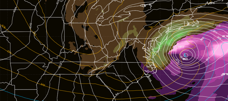
So with that said, I think our range of possibilities has narrowed. Instead of anything from SENJ rain/NWNJ jackpot to just snow/rain showers from an out to sea miss, I am now leaning towards a range of all snow for NJ to an out to sea miss with snow/rain showers. The latest data suggests a SENJ snow jackpot or a close miss out to sea.
We are learning what to look for though. And that is separation between the lower heights associated with Friday’s rain and the lower heights associated with the Sunday-Monday storm potential. The model runs that are missing out to sea (Euro operational. GFS AI) all keep those lower height areas connected which also keeps the ridging to the N of it connected. This produces the progressive out to sea solution of the S stream energy and just leaves N stream energy only to come through NJ with snow showers, even rain showers. The models that are hitting (GFS Operational, Canadian, Euro AI, UK, ICON, JMA, etc.) are all keeping those pieces separated with a little ridging between. So if you want to see the snowstorm, look for the separation. If you don’t want the snowstorm, look for the Friday storm energy to hang back and influence the incoming energy of the Sun-Mon storm in a progressive manner. That’s about all I can take from the current data. We need more time and will likely need until Friday for answers/first map.
A lot of you are asking me in comments and even private messages about specific timing. My timing assessment is still just “Sunday-Monday” all hours. Some models start the storm early Sunday morning and end Monday morning. Other models start the storm Sunday night and end it Monday night. So, until we see a further consensus on time narrowing, our suggested time frame will include all hours of both Sunday-Monday. Again, we should have answers and better timing suggestions come Friday. We’re still very much in a mode of “will there be a snowstorm or not” which we have to solve before suggesting the timing and specific amounts from a snowstorm.
In English: Models are doing their thing where they spray back and forth (direct NJ hit vs. out to sea). The possibility is still very much on the table. The data seems to be targeting SENJ with the most amount of snow whether a graze or a solid statewide hit. Starting to lean away from the possibility of a farther NW solution where the jackpot falls on SEPA/EPA/NWNJ (SENJ sees rain). I think we’re closing in on a range that includes snow for all of NJ (SENJ jackpot) to a miss out to sea with still lighter snow showers for NJ. Confidence will increase each day closer to the event with hopefully some concrete-enough consensus for a first call map Friday in the case of a suggested hit. More to come. Be safe! JC
Premium Services
KABOOM Club offers an ad-free environment, inside info (Above and Beyond) forecast discussion, your questions prioritized, and early storm impact maps and video releases (ahead of the public). At $1.99 per month, it’s an extremely feasible way to show additional support for Weather NJ and you can turn it on and off for however many months you wish. Think of it as a tip jar with perks. Available onFacebook or Patreon.
My Pocket Meteorologist (MPM), in partnership with EPAWA Weather Consulting, offers professional/commercial interests, whose businesses depend on outdoor weather conditions (snow plowing, landscaping, construction, etc.), with hyper-local text message alerts/forecasts from real meteorologists and access to the MPM premium forum—the most comprehensive and technical forecast discussion available for PA and NJ commercial interests.
KABOOM Shop is live if you want some KABOOM or Weather NJ Merch!
Sign up for ZoneWatch Radar and get 10% off
Jonathan Carr (JC) is the founder and sole operator of Weather NJ, New Jersey’s largest independent weather reporting agency. Since 2010, Jonathan has provided weather safety discussion and forecasting services for New Jersey and surrounding areas through the web and social media. Originally branded as Severe NJ Weather (before 2014), Weather NJ is proud to bring you accurate and responsible forecast discussion ahead of high-stakes weather scenarios that impact this great garden state of ours. All Weather. All New Jersey.™ Be safe! JC


LOCAL FORECAST | INTERACTIVE RADAR | LATEST NJ WEATHER ALERTS | WEDDING FORECAST| PRIVACY POLICY
© Copyright 2026 Weather NJ LLC. All Rights Reserved.
Some information that can be found on our website is provided by a private weather station and is not an officially recognized station for weather reporting. Though we always strive to achieve accurate reporting for our own use, it is important that you do NOT depend on the data provided here for any purpose.
