

Weekend Winter Storm Detected

Discussion: The weekend storm system is a go. I’ve tracked this storm signal since just before Christmas. It originally looked like an all-rain solution but between Christmas and New Years, has transitioned into more of a winter storm for at least some of NJ, mainly NWNJ/NNJ.
The reason there is now cold involved with this setup is fascinating from an upper-level look. First, we have two energy streams to deal with this Thursday. Each stream has its own low which will fail to interact with each other enough to produce a NJ storm system. This was the first signal I was monitoring for Jan 3-4. The southern stream low will miss well to the S/SE of NJ. The northern stream system, however, could graze over NJ with some light flurries or even snow showers possible but with little-to-no accumulation. There’s not much there other than adequate cold and a very weak/disorganized low. These two lows will then go on to form a singular oceanic storm system that tracks up to the 50/50 location (lat/lon) later this weekend. This is very important because a 50/50 low acts as a blocking mechanism for areas below it (including the NE US and NJ) via west side of cyclonic steering flow.
In this case the 50/50 low will hold a mid-level ridge in place spanning from the Great Lakes eastward into the NE US at a flat/negative angle. That ridge contains the adequate cold air mass to 1 allow snow to form and fall and 2 prevent the low from tracking further NW inland. So at the end of the day, its the same upper-level dynamics to our N and NE (downstream) as it would be with a traditional west-based -NAO block. Also in this case we do not have a favorable upstream pattern that is traversing downstream to NJ. Instead, we have a jet stream that is slightly buckling and slowing down due to the pseudo block created by the 50/50 low and NE US ridge. Therefore, the low will have no where to go but to the NE or E/NE once it encounters the pseudo block. And that constitutes our storm and potential snow this weekend.
Up until today, I was monitoring ensemble members to decide go vs no go on this storm system. The members have done nothing but tighten their cluster towards a storm location, so I’m now a go. It is time to focus on surface details and expectations which I expect to evolve further over the next 24-72 hours of data. We still have two possibilities:
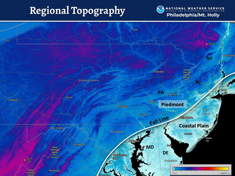
1 – The system tracks closer to NJ coast. This produces strong onshore flow that roasts the lower levels above freezing all the way to the fall zone/line which is where flat coastal plain starts increasing in elevation. You might notice this line is incredibly close to the I-95 corridor axis. This can be depicted here:
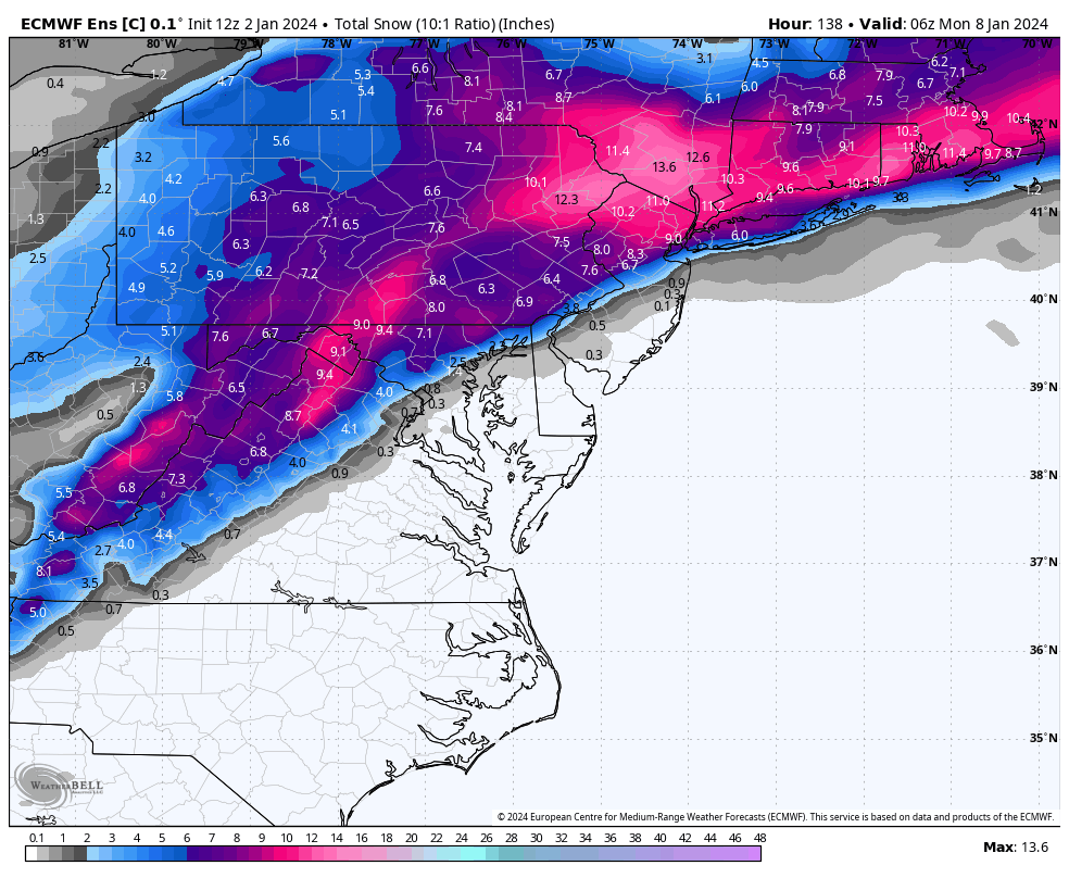
I am starting to lean towards this first scenario which would cause a NWNJ jackpot for highest snow accumulations. It’s more common of a solution given this setup and now has strong support by most model guidance. Here is the 12Z Euro ensemble control run which is closest to my thoughts as of this moment:
2 – The system is suppressed southward and only brings lighter snow to SNJ while cutting off to the NW for NNJ. This idea has lost most, if not all, model support. I’d give it a low chance of happening. I currently like the first possible solution much better. But that still leaves an area of uncertainty…
NWNJ will likely be all snow with the highest snow totals. SENJ will likely be all rain with the highest winds occurring along the immediate ECNJ/SENJ coast. These ideas are becoming firm. This leaves an area along and just NW of the I-95 corridor in a zone of uncertainty. If the low is stronger then it will mean a stronger high block to the N and a slightly S low track. This would bring plowable snow to the 95 area of uncertainty. If the low is weaker then the high block will also be weaker and allow the low to take a slightly N track. This would still bring the biggest snow to NWNJ but the 95 area would likely share the same rainy/windy fate as SENJ. We will need to wait this specific evolution out between now and Thursday before we start issuing specific anticipated snow accumulation totals.
ECNJ and SENJ are subject to strong marine flow off the ocean. I could see wind gusts of 40-50+ mph along the coast and gusts to 30-40 mph away from the ocean. Minor coastal flooding is likely between Saturday PM and Sunday AM.
In English: A storm is brewing for late this weekend. Should start as early as Saturday afternoon/evening and wrap up by Sunday afternoon, with peak conditions occurring between late Saturday night and noon Sunday. At this point, it’s becoming likely that NWNJ sees the highest snow totals and that SENJ sees all rain and wind. I-95 and areas just surrounding such are in the highest zone of uncertainty. And although today’s models leaned away from 95 snow, I expect there to be wavering back-and-forth over the next few days which keeps said zone yet TBD regarding precipitation type. We have a long way to go with at least slight changes expected. That is why there are no issued snow maps yet. The storm is a go but it is still too soon for specific ground conditions. Need another day or two. But you should now plan for a disruptive Saturday PM through all of Sunday AM. It looks like conditions should improve by Sunday afternoon. Be safe! JC
Premium Services
KABOOM Club offers inside info forecast discussion, your questions answered, and early storm impact maps (ahead of the public). At a buck per month, it’s an extremely feasible way to show support.
My Pocket Meteorologist (MPM), in partnership with EPAWA Weather Consulting, offers professional/commercial interests, whose businesses depend on outdoor weather conditions (snow plowing, landscaping, construction, etc.), with hyper-local text message alerts/forecasts and access to the MPM premium forum—the most comprehensive and technical forecast discussion available for PA and NJ.
Get your KABOOM Inside Out pajamas and more at the KABOOM shop!
Jonathan Carr (JC) is the founder and sole operator of Weather NJ, New Jersey’s largest independent weather reporting agency. Since 2010, Jonathan has provided weather safety discussion and forecasting services for New Jersey and surrounding areas through the web and social media. Originally branded as Severe NJ Weather (before 2014), Weather NJ is proud to bring you accurate and responsible forecast discussion ahead of high-stakes weather scenarios that impact this great garden state of ours. All Weather. All New Jersey.™ Be safe! JC


LOCAL FORECAST | INTERACTIVE RADAR | LATEST NJ WEATHER ALERTS | WEDDING FORECAST| PRIVACY POLICY
© Copyright 2026 Weather NJ LLC. All Rights Reserved.
Some information that can be found on our website is provided by a private weather station and is not an officially recognized station for weather reporting. Though we always strive to achieve accurate reporting for our own use, it is important that you do NOT depend on the data provided here for any purpose.
