

Weekly Outlook and Snow Signal Update
Discussion: As expected, we saw some wild hits and misses on the models this past weekend. The models, however, failed to converge on a favorable solution, for Thursday-Friday Jan 15-16 like what the GFS had Friday and what the Euro moved to Friday night/Saturday morning. I was waiting until today to see if the GFS, Canadian and Euro were all going to be in the same camp, at the upper levels, or not before issuing a forecast for the week. As it stands right now, there is still a lot of storm energy in the upper levels expected to push through for the Jan 15-20 period and now seems like through the 24th. But getting that to translate into a surface snowstorm solution is the problem here.
Although we have a nicely carved trough for the E US and a ridge in the W US, there exists something called a kicker mechanism, Consider the next two images showing upper level (500mb) cyclonic vorticity, aka snowstorm fuel in this case. The kicker circled from next approaching trough and how it affects (kicks) the S branch of leading trough which prevents the proper phasing and coupling of the jet streams.
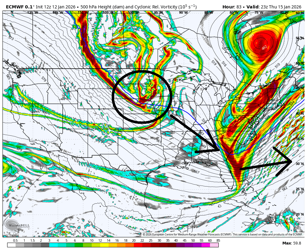
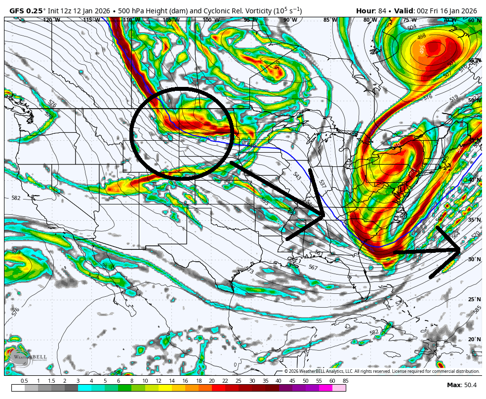
The next trough wants to move in right behind the one responsible for this Thursday-Friday. Therefore, the steering currents coming off that second trough “kicks” the southern energy of the first trough out ahead of the storm potential, preventing the perfect phase we were seeing Friday night. This keeps the two branches of energy separated…the S piece as rain out to sea and the N piece as just snow showers for New England and NJ. If we want a snowstorm this Thursday, we would want to see that second trough slow down and let the first trough do its phasing and storm enhancement. That second trough, however, will be the trough for the Jan 18-19 signal which is still on the table as of now. But that too has a chance of seeing a kicker by the trough responsible for a Jan 22-24 signal. We have three troughs reloading after each other, all containing powerful upper-level storm energy. But if they are too close together, the one behind blows/shears out the one in front of it. They need to separate their timing.
From this point, I think the Thursday-Friday system gets sheared out and NJ is left with some lighter snow shower potential. But the two troughs after that (Jan 18-19 and Jan 22-24 signals) will likely see big changes in timing being 7 and 10 days away. There are simply too many upper-level dynamics in a sea of chaos for there not to be. The last 48 hours of data change are a good example of that.
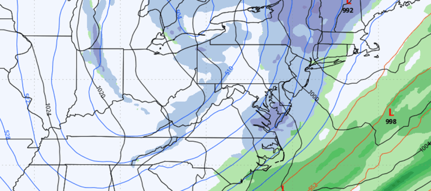
We are, however, only 72 hours away from this Thursday and an actual forecast is owed. We’re colder today in the wake of yesterday’s cold front. We moderate a bit tomorrow (Tuesday and Wednesday) as we’ll be in the warm sector of another approaching trough/cold front only this time an Arctic front that will knock temps down a second gear from how today feels. That front should push through Thursday morning making for an early Thursday morning realization of the day’s high temp. Temps will then fall through Thursday with light precipitation possible Thursday night into Friday morning, when well-below freezing. It could start as rain earlier Thursday but given the expected temp drop, it would change to snow by Thursday evening. Despite strong dynamics in the upper-levels, the most responsible and reasonable forecast from this range would be scattered snow showers capable of accumulating a coating to an inch or two at most. I’ve seen larger comebacks in shorter amounts of time but from this range, a comeback would be a wildcard possibility of the stronger upper levels getting involved. We’d need the second trough to slow down and would need to see the tight wrap-up of cyclonic vorticity that we saw on the GFS Friday/Euro Saturday.
I’ve yet to take Jan 18-19 snow signal off the table (Sunday-Monday) because we are farther away. I will still be casually monitoring this over next few days. The surface not picking up much but again, the energy exists in the upper levels. If a weaker Jan 15-16 outcome translates to a stronger Jan 18-19 outcome, it would be a short punt and changeover. Will probably give it until Thursday before deciding go vs no-go and issuing an actual forecast for Jan 18-19. Then Jan 22-24 is the next signal after that. I don’t see any torches or warmups in the near future, mostly trough after trough. This is a good sign for the snow lover overall if you can get past the disappointment of this Thursday-Friday likely being just snow showers instead of a snowstorm. Onward we go.
In English: Today (Monday) is colder. Tomorrow and Wednesday are a bit milder. A strong cold front then pushes temps down for Thursday into next week. Rain changing to snow showers are possible Thursday into Friday (barring a comeback of the larger snow system) and then still monitoring snow potential for Sunday-Monday followed by another next week. No forecasts yet for these systems just monitoring as signals. A cold and active pattern remains in place. Whether or not the ingredients will come together and bake us a cake is still yet TBD. Be safe! JC
Premium Services
KABOOM Club offers an ad-free environment, inside info (Above and Beyond) forecast discussion, your questions prioritized, and early storm impact maps and video releases (ahead of the public). At $1.99 per month, it’s an extremely feasible way to show additional support for Weather NJ and you can turn it on and off for however many months you wish. Think of it as a tip jar with perks. Available onFacebook or Patreon.
My Pocket Meteorologist (MPM), in partnership with EPAWA Weather Consulting, offers professional/commercial interests, whose businesses depend on outdoor weather conditions (snow plowing, landscaping, construction, etc.), with hyper-local text message alerts/forecasts from real meteorologists and access to the MPM premium forum—the most comprehensive and technical forecast discussion available for PA and NJ commercial interests.
KABOOM Shop is live if you want some KABOOM or Weather NJ Merch!
Sign up for ZoneWatch Radar and get 10% off
Jonathan Carr (JC) is the founder and sole operator of Weather NJ, New Jersey’s largest independent weather reporting agency. Since 2010, Jonathan has provided weather safety discussion and forecasting services for New Jersey and surrounding areas through the web and social media. Originally branded as Severe NJ Weather (before 2014), Weather NJ is proud to bring you accurate and responsible forecast discussion ahead of high-stakes weather scenarios that impact this great garden state of ours. All Weather. All New Jersey.™ Be safe! JC


LOCAL FORECAST | INTERACTIVE RADAR | LATEST NJ WEATHER ALERTS | WEDDING FORECAST| PRIVACY POLICY
© Copyright 2026 Weather NJ LLC. All Rights Reserved.
Some information that can be found on our website is provided by a private weather station and is not an officially recognized station for weather reporting. Though we always strive to achieve accurate reporting for our own use, it is important that you do NOT depend on the data provided here for any purpose.
