

What to Expect from Erin for New Jersey
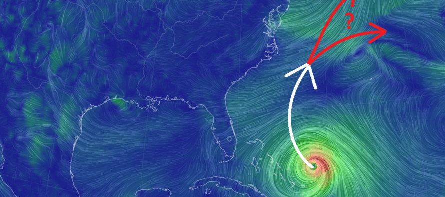
Discussion: The first thing I want to emphasize is that Erin will not be striking New Jersey with a major hurricane, yet alone the US east coast. I’ve seen some content out there suggesting such and it lacks any sort of evidence-based foundation whatsoever. Whether it’s a click-bait attempt or folks getting juked out of their socks by every little trochoidal oscillation, it’s not the case that Erin will hit the E US. 1988 Jerry Rice didn’t even juke the defense out as hard as what I’ve seen the last few days. There’s a ridge setting up over the SE US/SC US and another out near Bermuda. The storm is going to split the difference, finding the weakness between, and pass offshore of NJ and the US east coast.
Let’s cover this week in NJ before we dive into the more confident take on Erin. The single phrase that can cover this week is cool, cloudy, breezy with showers. Wednesday and Thursday have a better chance for showers and breeze but the entire week looks stuck in the 70s for high temperatures less Friday which could rise just over 80. A secondary impact of Erin is the elimination of the super-comfortable dew point temperatures (humidity). So while Erin will not strike the Mid-Atlantic US, it sure as heck messed up the weather pattern…or at least delayed it until this weekend. However, even though it will still be a bit humid and with showers Tuesday night through Friday morning, the lower temperatures will still provide some relief.
So, Erin will not bring primary impacts to NJ or the US east coast. That means no landfall, no destructive winds, no tens of inches of rainfall, no life-threatening storm surge. However, Erin will bring secondary impacts…not because of a closer track to the US east coast but because of Erin’s expansion as it begins extra-tropical transition with typical latitude gain.
Erin is currently off the SE Bahamas and has made its turn from a west heading to now a NW heading. It’s finding the weakness between the ridges. I expect Erin’s center and destructive wind core to pass between Bermuda and OBX between Tuesday night and Wednesday before turning away from the E US and heading NE back out into the Atlantic Ocean to the S of New England. Again, though, Erin’s wind and rain field should expand as it passes along the coast. This brings the possibility for a windy coast with showers Tuesday night through Friday morning. Neither the wind nor rain will feature anomalous hazards for NJ. The most concerning aspect of Erin’s secondary impacts will be in the form of rough surf, rip currents, beach erosion and minor, possibly moderate, coastal flooding. Since the upper jet, from the bottom of the trough that moved in, will be ripping out of the W/NW, it will confidently steer Erin back out to sea once Erin reaches it’s westernmost track extent around Wed-Thurs. It’s a classic recurve with grazing secondary impacts. Could have been MUCH worse.
This is an experienced surfer’s paradise. Let’s call it what it is. But it can be a nightmare for an inexperienced swimmer. It’s the kind of situation where you’ll probably hear of injury/death somewhere on the US east coast by Friday because swimmers didn’t listen to lifeguards. But it’s also the kind of situation that surfers might talk about for years or even generations. The choice is yours. The risk is yours to take. But I highly recommend listening to authorities and lifeguards. It’s no longer the kind of situation where it will be sunny with big waves. It’s now more of an angry surf with rain and wind from Erin’s outer bands after she expands coming out of the SE Bahamas region.
Once Erin gets further out to sea (by Friday and the weekend), then the winds will become northerly behind her, and we’ll get our lower dew points (lower humidity). But for the next couple of days (Tuesday through Friday morning) expect fringe tropical impacts along the Jersey Shore with showers possibly moving well onshore over land. Hurricane season is for sure heating up as a few more waves could follow behind Erin from the W Africa origin (Cape Verde Storms). You know I’ll be tracking.
In English: This week looks cooler than it has been (relative) however plenty of clouds, breeze and showers are possible mainly from Erin’s far W side of secondary impacts. Erin will not make primary impact (landfall) on NJ or the E US coast. It’s just that Erin will expand its rain and wind field to the point of reaching NJ when it passes offshore between Tuesday night and Friday morning (primarily Wednesday night into Thursday morning). The lower dew points (lower humidity) have been delayed until Friday-Saturday…not because Erin is taking a further W track but because Erin is expected to increase its diameter larger than originally expected. OBX will likely feel the strongest secondary impacts, possibly in the form of tropical storm conditions at times. NJ is likely looking at sub-tropical storm rain and wind values. Have a great rest of your Monday night and please be safe! JC
Premium Services
KABOOM Club offers ad-free content, inside info forecast discussion, your questions answered, and early storm impact maps and video releases (ahead of the public). At $1.99 per month, it’s an extremely feasible way to show additional support for Weather NJ and you can can turn it on and off for however many months you wish. Think of it as a tip jar with perks. The public eventually sees all info discussed in premium areas. Available onFacebook or Patreon.
My Pocket Meteorologist (MPM), in partnership with EPAWA Weather Consulting, offers professional/commercial interests, whose businesses depend on outdoor weather conditions (snow plowing, landscaping, construction, etc.), with hyper-local text message alerts/forecasts and access to the MPM premium forum—the most comprehensive and technical forecast discussion available for PA and NJ.
Jonathan Carr (JC) is the founder and sole operator of Weather NJ, New Jersey’s largest independent weather reporting agency. Since 2010, Jonathan has provided weather safety discussion and forecasting services for New Jersey and surrounding areas through the web and social media. Originally branded as Severe NJ Weather (before 2014), Weather NJ is proud to bring you accurate and responsible forecast discussion ahead of high-stakes weather scenarios that impact this great garden state of ours. All Weather. All New Jersey.™ Be safe! JC


LOCAL FORECAST | INTERACTIVE RADAR | LATEST NJ WEATHER ALERTS | WEDDING FORECAST| PRIVACY POLICY
© Copyright 2026 Weather NJ LLC. All Rights Reserved.
Some information that can be found on our website is provided by a private weather station and is not an officially recognized station for weather reporting. Though we always strive to achieve accurate reporting for our own use, it is important that you do NOT depend on the data provided here for any purpose.
