

What to Expect Monday (Tomorrow)

Discussion: This article will focus on the specific period between late tonight (Sunday night) through Tuesday morning. During this time, severe weather is possible in the form of straight-line winds, tornadic winds and/or hail. While lightning is not an official severe weather parameter, it’s also on the table for this period.
For the setup, if you’re familiar with the Norwegian Cyclone Model, we have a low bombing out in the W Great Lakes area. A warm front is attached to its E side and extents into New England (already N of NJ latitude). A cold front is attached to the low’s S side and extends down through the MidWest US into Texas. This means a major winter snow storm for the N Plains into W Great Lakes. But it also means a recipe for severe weather outbreaks in the warm sector (the SE side of the low). That’s what will be moving through/over NJ between late tonight and early Tuesday morning.
In the warm sector, you have air rushing S to N aloft meeting with the general clockwise (cyclonic) flow around the low at differing levels of the lower atmosphere. This can create horizontal roll and ultimately a tornado if an updraft can stand part of the roll upwards so that the adjacent side of the roll can shoot downwards to the ground. This warrants the concern for tornadic activity Monday. The best severe weather dynamics are going to be to the SW of NJ. However, SWNJ could be included in the heightened concern. This is a lower issue for other parts of NJ, especially NENJ/ENJ mainly because of timing which I’ll cover in next paragraph. But basically draw a line from Cape May through Trenton into NWNJ. Everyone W of that line is on the table to potentially see severe winds. Everyone E of that line has a lesser chance to see severe winds but are still on the hook for a rainy/windy night.
The intensity of the thunderstorms/winds will rely heavily on diurnal heating Monday. That is the sun reaching and heating the surface-destabilizing the lower atmosphere so that the air wants to rise into colder air aloft. So if Monday is more of a cloudy/rainy day, it will inhibit diurnal instability and would mean more of a breezy/windy/downpour situation come the main event later Monday night. If the sun is allowed to reach the surface in more of a mostly sunny Monday, then we should expect a more violent stormfront later Monday night (frequent lightning, damaging winds, tornadoes, etc.). The term we use for this is “suns out guns out” with regard to thunderstorm fuel. So again, Monday night’s storm intensity will depend heavily on how much the atmosphere can destabilize during the day into sundown.
The stormfront is expected to reach SWNJ around/just after sundown. That’s why SWNJ has a better chance to see the severe winds. This should be later Monday night. After that, you have the main low occluding off the jet stream, you have loss of diurnal heating, and since the trough is tilting negative, you have cold SE marine flow ripping off the Atlantic Ocean towards the low. The colder marine air will likely stabilize the stormfront into just breezy/windy showers. Again, draw the line from Cape May to Trenton.
So, I would expect waves of rain showers to push S to N into NJ tonight as the warm sector establishes over the E US. Expect these waves of rain to push S to N from about midnight tonight (Sunday night) through about sunrise Monday morning. There should be breaks within the waves and possibly a lull or two. Perhaps a lull in the morning, more showers around noon, and then another lull afternoon into evening. The afternoon lull will determine how juiced the final stormfront will be by how cloudy or clear it is. The main stormfront should then first push into SWNJ by about 7-8pm, cross NJ from SW to NE and clear NENJ by 1-2am. Again, how much destabilization happens Monday afternoon-evening determines how hard SWNJ and possibly other parts of NJ gets hit by the main Monday night stormfront. It’s important for all of NJ to expect a rainy/windy period though. Given the dynamics involved, precipitation could end with a brief wintry mix of snow for areas like the Poconos into NWNJ elevations. We put together the following map for wind and severe weather expectations:
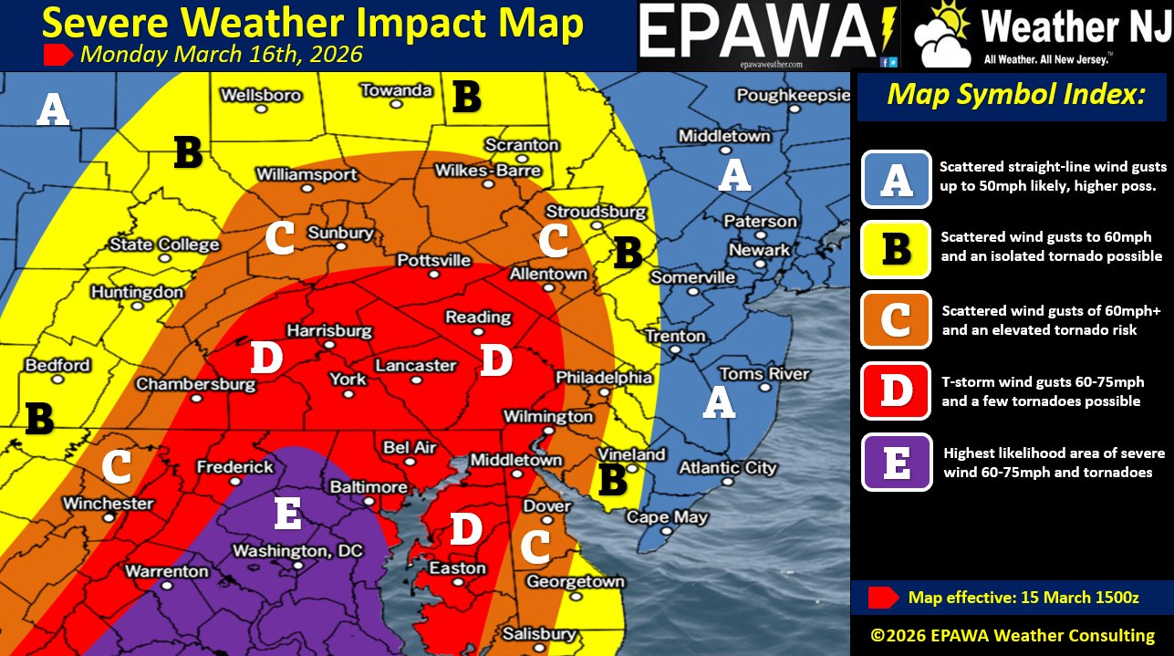
In English: We’re in for a series of spring weather episodes between about midnight tonight and early Tuesday AM hours. First, temperatures are going to warm tonight into tomorrow (there could be dense fog). Much of NJ will reach into the 60s again by Monday morning. However, a decent amount of rain is expected tonight through tomorrow night. Not a continuous downpour but more like waves of showers and downpours with a few lulls between. Winds should gradually increase Monday out of the S and come to a peak when the main cold-front-driven stormfront comes through later Monday night. Scattered within all of these waves of rain and warmer temps are the potential for localized thunderstorms producing downpours, lightning, severe wind gusts which would mainly come from straight-line winds but also possibly tornadoes. See the above map for intensity expectations. Areas to the W of a line drawn from Cape May through Trenton into NWNJ have the best chance to see the severe weather potential. But all of NJ is on the hook for at least rain and wind. While this could easily change, the main batches of rain look like midnight tonight to 7am, 11am to 3pm, and then 7pm to midnight Monday night. Everything tapers off by early Tuesday AM hours possibly in the form of a wintry mix/snow for NWNJ elevations. The volatile pattern then begins to stabilize next week. I’ll have the weekly outlook posted tomorrow which will update this situation. Have a great rest of your Sunday and please be safe! JC
Premium Services
KABOOM Club offers an ad-free environment, inside info (Above and Beyond) forecast discussion, your questions prioritized, and early storm impact maps and video releases (ahead of the public). At $1.99 per month, it’s an extremely feasible way to show additional support for Weather NJ and you can turn it on and off for however many months you wish. Think of it as a tip jar with perks. Available onFacebook or Patreon.
My Pocket Meteorologist (MPM), in partnership with EPAWA Weather Consulting, offers professional/commercial interests, whose businesses depend on outdoor weather conditions (snow plowing, landscaping, construction, etc.), with hyper-local text message alerts/forecasts from real meteorologists and access to the MPM premium forum—the most comprehensive and technical forecast discussion available for PA and NJ commercial interests.
KABOOM Shop is live if you want some KABOOM or Weather NJ Merch!
Jonathan Carr (JC) is the founder and sole operator of Weather NJ, New Jersey’s largest independent weather reporting agency. Since 2010, Jonathan has provided weather safety discussion and forecasting services for New Jersey and surrounding areas through the web and social media. Originally branded as Severe NJ Weather (before 2014), Weather NJ is proud to bring you accurate and responsible forecast discussion ahead of high-stakes weather scenarios that impact this great garden state of ours. All Weather. All New Jersey.™ Be safe! JC


LOCAL FORECAST | INTERACTIVE RADAR | LATEST NJ WEATHER ALERTS | WEDDING FORECAST| PRIVACY POLICY
© Copyright 2026 Weather NJ LLC. All Rights Reserved.
Some information that can be found on our website is provided by a private weather station and is not an officially recognized station for weather reporting. Though we always strive to achieve accurate reporting for our own use, it is important that you do NOT depend on the data provided here for any purpose.

)