

White Christmas Storm Signal

Discussion: The current system today should begin tapering off for SNJ after midnight tonight. It will continue to taper from SW to NE and will take longer for CNJ and then ultimately NNJ by later tomorrow. Most areas should clear by Friday evening to set up a colder weekend. Most NJ afternoon highs under 40 and overnight lows in teens/20s. Immediate SENJ coastal areas into the 40s for highs and down just below freezing at night. Clear and under the influence of approaching high pressure from the W. I’ll cover this more in tomorrow’s weekend outlook.
Now onto the White Christmas Storm Signal. I want to be absolutely clear that I am not issuing a forecast for this. I know just the general possibility is going to generate a lot of rumor and hype. But I also want to point out what I am seeing that correlates with the Dec 11-15 pattern change we just encountered. So with that said, I am only going to casually monitor the Dec 23-24 wintry storm signal over this weekend. If we get to Sunday and the signal is still showing strong, then I will move into serious tracking mode. For now, let’s talk meteorology.
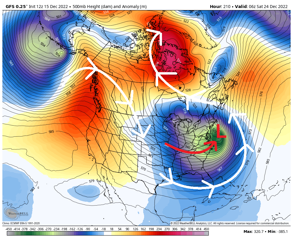
The Greenland block formed last week as expected and will now be a critical player for Dec 23-24. What we’ve lacked so far was a +PNA (W US ridge). This has been generating most troughs into the area between the C US and E US but allowing a sneaky ridge to build off the SE US. This pattern ultimately produces what we’ve seen twice now…snow for NWNJ and rain for the rest of NJ. What has be a bit stoked about Dec 23-24 is the appearance of a W US ridge working in tandem with the block just S of Greenland to herniate a trough into the E US, most specifically setting up the Mid-Atlantic US for a snowstorm just before Christmas time. The below image from the latest GFS illustrates this when looking at 500mb data and shows the general direction of the jet stream needed to power a wintry surface storm for New Jersey. It’s not exact but I want you to see how this pattern becomes favorable for NJ to see snow. The 500mb isobars basically steer the low:
These are the features that I am going to pay attention to this weekend. I will not be looking at surface output seriously until Sunday (if we still have this setup showing). It could very well drop off and I want to make that crystal clear. If you look at surface output today you would see NJ getting hit on both the GFS and Euro. It’s social media click bait candy basically. It’s not worth it. Don’t torture yourself. Surface output is going to spray back and forth from model suite to model suite. Let’s see if the block, trough, and W US ridge are still modeled this way on Sunday and take it from there. At this point you should consider this possibly happening and start to have backup plans in mind. But you should not consider this actionable yet. Let’s get to Sunday. Thank you for your patience and understanding. Hopefully I’ve conveyed the possibility without hyping the probability of it.
In English: The current system exits for all tomorrow and sets up a cold weekend. I’m then casually watching the Friday-Saturday Dec 23-24 possibility for a winter storm in New Jersey. Going to give it the weekend to see if the data and live observations hold serve. If still showing on Sunday then serious tracking will begin. For now we are too far out to forecast this but want to bring it to your attention as a possibility. Have a great rest of your Thursday and please be safe! JC
Jonathan Carr (JC) is the founder and sole operator of Weather NJ, New Jersey’s largest independent weather reporting agency. Since 2010, Jonathan has provided weather safety discussion and forecasting services for New Jersey and surrounding areas through the web and social media. Originally branded as Severe NJ Weather (before 2014), Weather NJ is proud to bring you accurate and responsible forecast discussion ahead of high-stakes weather scenarios that impact this great garden state of ours. All Weather. All New Jersey.™ Be safe! JC


LOCAL FORECAST | INTERACTIVE RADAR | LATEST NJ WEATHER ALERTS | WEDDING FORECAST| PRIVACY POLICY
© Copyright 2026 Weather NJ LLC. All Rights Reserved.
Some information that can be found on our website is provided by a private weather station and is not an officially recognized station for weather reporting. Though we always strive to achieve accurate reporting for our own use, it is important that you do NOT depend on the data provided here for any purpose.
