

Wind Event Approaching
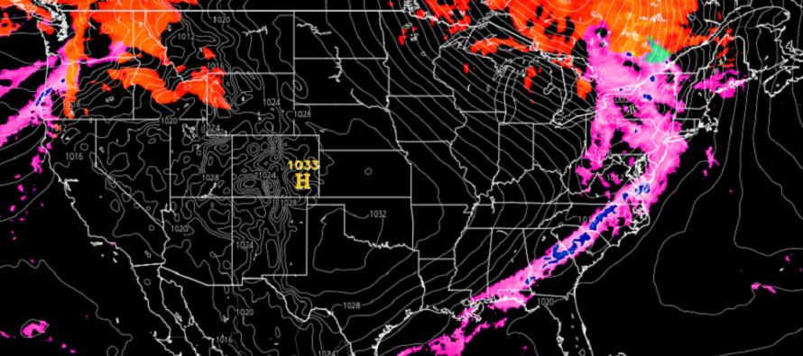
Discussion: Tomorrow (Wednesday) is going to be one of those volatile days I spoke about in this week’s outlook. The setup includes strong upper-level dynamics (a vort-phasing trough) over the Great Lakes enhancing (bombing out) a surface low just N of the Great lakes. This will rip an attached cold front through most of the E US tomorrow, especially with eastward-moving high pressure forming over Missouri and reinforcing the front. Ahead of the cold front will be strong S/SW flow enhanced by the departing high’s return flow pressure gradient. Behind the cold front will be stiff W/NW flow enhanced by the primary Canadian surface low and the SE US high. Let’s break it down by hazard:
Rain doesn’t look too bad. Most data suggests less than an inch for all of New Jersey. A reasonable expectation is between a quarter and three-quarters of an inch. The timing of rain looks like sunrise to sunset Wednesday with the bulk of it falling between late-morning and afternoon.
Wind is likely the more noticeable hazard. Most of New Jersey can expect gusts in the 30-40mph range. Higher elevations of NNJ/NWNJ could see gusts in the 40-50mph due to closer proximity to the stronger jet overhead. The SENJ coast might take the strongest winds to the face (exceeding 50mph) between Wednesday afternoon and evening being open to the water. Soundings indicate an inversion in the 700-750mb range which should keep the stronger jet dynamics (damaging wind potential) aloft. The wind should gradually build with the rain Wednesday morning, peak between afternoon and early evening, and subside overnight as cold air moves in.
I think areas in the Northern Gulf/SE US region are in for a rocky night (tonight) into tomorrow morning. That is where thunderstorms will be strongest with possible tornadoes. I think such dynamics will be mostly inhibited for New Jersey by the time the rainfront reaches us later Wednesday morning. But just to be safe, let’s allow a small isolated chance of thunderstorms or a tornado.
In English: Temps should rise into the mild category Wednesday morning as rain moves in. Rain should fall, steady at times, between Wednesday morning and late-afternoon. Winds should pick up between afternoon and evening. NWNJ elevations and the SENJ coast should see the highest wind gusts, possibly exceeding 50mph. The rest of the state (lower elevations and away from the ocean) will still likely see gusts into the 30-40mph range. Winds should then drop off overnight into Thursday. We then become colder again heading into the weekend. Have a great rest of your Tuesday and please be safe! JC
Premium Services
KABOOM Club offers inside info forecast discussion, your questions answered, and early storm impact maps (ahead of the public). At a buck per month, it’s an extremely feasible way to show support.
My Pocket Meteorologist (MPM), in partnership with EPAWA Weather Consulting, offers professional/commercial interests, whose businesses depend on outdoor weather conditions (snow plowing, landscaping, construction, etc.), with hyper-local text message alerts/forecasts and access to the MPM premium forum—the most comprehensive and technical forecast discussion available for PA and NJ.
Jonathan Carr (JC) is the founder and sole operator of Weather NJ, New Jersey’s largest independent weather reporting agency. Since 2010, Jonathan has provided weather safety discussion and forecasting services for New Jersey and surrounding areas through the web and social media. Originally branded as Severe NJ Weather (before 2014), Weather NJ is proud to bring you accurate and responsible forecast discussion ahead of high-stakes weather scenarios that impact this great garden state of ours. All Weather. All New Jersey.™ Be safe! JC


LOCAL FORECAST | INTERACTIVE RADAR | LATEST NJ WEATHER ALERTS | WEDDING FORECAST| PRIVACY POLICY
© Copyright 2026 Weather NJ LLC. All Rights Reserved.
Some information that can be found on our website is provided by a private weather station and is not an officially recognized station for weather reporting. Though we always strive to achieve accurate reporting for our own use, it is important that you do NOT depend on the data provided here for any purpose.
