

Wind Storm Detected for Tues-Wed
Discussion: The next few weeks of weather has a much more interesting look than the last month or so that included the rainy mild December. We currently have synoptic storm systems lined up almost every 3-5 days from now through the end of January. We have a Polar Vortex split occurring in the middle of it which should bring much colder air to the US lower-48. We have insane blocking near Greenland at times with a few opportunities for more of a statewide NJ snowstorm. We just need to get through a few warmer storm systems first.
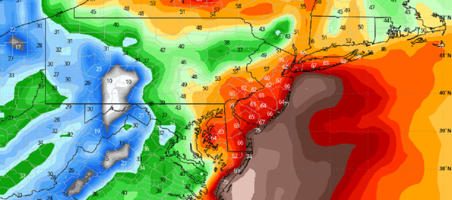
The first and more immediate storm signal occurs on Tuesday-Wednesday (Jan 9-10). Between late Monday night and Tuesday, two separate pieces of energy will come together out of the NW and off the Gulf of Mexico. The primary low should cut into the Great Lakes and possibly spawn off a secondary low (not a transfer) to track SE of NJ. The two lows will form a double barrel low configuration, too warm of a setup for NJ snow. It’s almost like a double warm sector. If no double barrel spawn off low, then the primary will still head to the Great Lakes. In either case, this will likely be a major snowstorm for the ~Chicago/Great Lakes area but not New Jersey. Extreme NWNJ elevations could possibly start wintry at the onset of precipitation but would quickly go over to rain like the rest of NJ. The estimated period of expected rainfall is generally from noon Tuesday to noon Wednesday with a widespread 1-2 inches of rainfall a good bet. Some of the guidance suggests greater than two inches of rainfall but let’s approach realistically and scale responsibly. The headline for this event will likely be winds. A high wind event. No matter what layer I look at (250mb, 500mb, 700mb, 850mb, 925mb, etc.), the winds are ripping out of the S/SE Tuesday evening into Wednesday morning. It’s a fierce warm sector feeding into the strong primary Great Lakes low. Based on what I’m seeing with the surface data, all of New Jersey should expect sustained winds of 15-25mph away from the ocean and 25-40mph along the immediate coasts of SNJ (Great Bay around Cape May through LBI and up to Monmouth Beaches). New Jersey should expect peak wind gusts of 35-50 mph away from the ocean and 50-70mph along the immediate coasts of SNJ. Regarding coastal flooding, the peak wind gust period should time with low tide. Water levels, however, could still be up due to proximity of the new moon, draining rainfall, and a higher low tide. I’d put the coastal flooding risk at minor for now.
The next storm signal is for ~Saturday, January 13. This looks like a second Great Lakes cutter which will also be too warm for snow. Another rain and wind event for NJ, though the wind values do not look as intense as this coming Tuesday-Wednesday’s. This system could trend warmer or colder but the significance of it is to mark the pattern change…the eventual introduction of true Arctic air behind it. This Arctic air is then modeled to stay in place over the E US until the third storm signal of interest.
The third storm signal of interest is around January 16-17 which next Tuesday-Wednesday. There will be no shortage of cold air in place. There are favorable upper-level dynamics and support modeled during this time. It’s all looking good from this range but we still need to respect the uncertainty of a 9 day storm signal. All I will be looking for over the next 3-4 days is for the signal to hold on the GFS and become supported on the Euro/Canadian/etc. If all that is met, come this Thursday, then serious storm tracking would begin Thursday night.
Beyond the three more immediate storm signals over the next 9 days, are two more vague signals through about January 24. After that, it looks like the E US could take a break from the Arctic invasion currently modeled to last from ~Jan 14-24. We could see the typical “January thaw” that occurs before cold resets/reloads happen in February.
In English: Expect a colder but drier period tonight through Monday. On Tuesday rain will move in (might start wintry for highest NWNJ elevations). Heavy rain and high winds are then likely Tuesday night into Wednesday morning with temperatures spiking into the 50s. Winds could become damaging, out of the S, especially along coastal areas. Power outages are very likely. We then clear out and cool down a bit until our next storm system ~January 13. Could be a wash. rinse. repeat. scenario of the Tuesday-Wednesday system. I’m then watching January 16-17 for a NJ snowstorm signal as well as two other general signals beyond that. The bottom line is that it’s going to get much colder and the active pattern will remain in place. Next up is the Tuesday-Wednesday rain and WIND event. Be safe! JC
Premium Services
KABOOM Club offers inside info forecast discussion, your questions answered, and early storm impact maps (ahead of the public). At a buck per month, it’s an extremely feasible way to show support.
My Pocket Meteorologist (MPM), in partnership with EPAWA Weather Consulting, offers professional/commercial interests, whose businesses depend on outdoor weather conditions (snow plowing, landscaping, construction, etc.), with hyper-local text message alerts/forecasts and access to the MPM premium forum—the most comprehensive and technical forecast discussion available for PA and NJ.
Get your KABOOM Inside Out pajamas and more at the KABOOM shop!
Jonathan Carr (JC) is the founder and sole operator of Weather NJ, New Jersey’s largest independent weather reporting agency. Since 2010, Jonathan has provided weather safety discussion and forecasting services for New Jersey and surrounding areas through the web and social media. Originally branded as Severe NJ Weather (before 2014), Weather NJ is proud to bring you accurate and responsible forecast discussion ahead of high-stakes weather scenarios that impact this great garden state of ours. All Weather. All New Jersey.™ Be safe! JC


LOCAL FORECAST | INTERACTIVE RADAR | LATEST NJ WEATHER ALERTS | WEDDING FORECAST| PRIVACY POLICY
© Copyright 2026 Weather NJ LLC. All Rights Reserved.
Some information that can be found on our website is provided by a private weather station and is not an officially recognized station for weather reporting. Though we always strive to achieve accurate reporting for our own use, it is important that you do NOT depend on the data provided here for any purpose.
