

Winter Storm a Go
Discussion: Models have continued to shift E with their surface output (how much snow falls and where). However the upper-levels indicate that the shift is not exactly as far E as you would think.
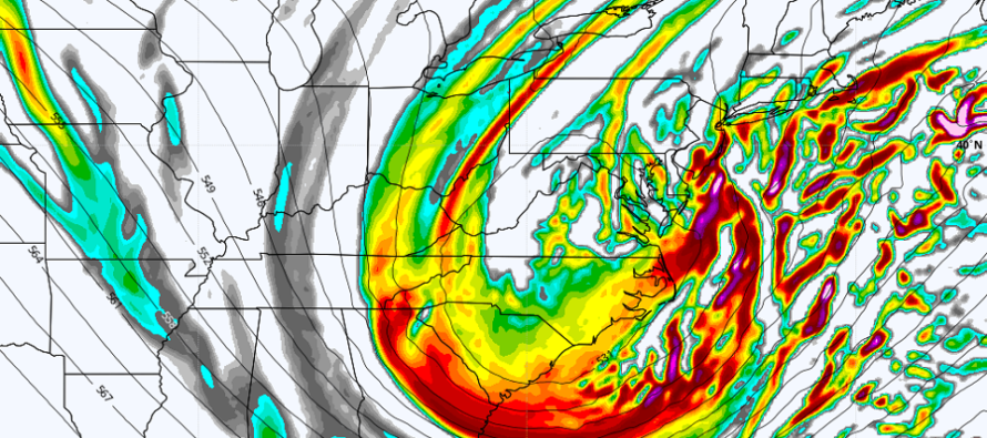
Some models, like the GFS and Canadian are still holding back some energy beneath the W US ridge but the N and S streams are still timing to produce a solid upper-level look (which cascades down and determines with the surface will be). The current surface output of said models are still brining significant snow to ECNJ/SENJ as the easternmost outliers. The NAM and Euro are suggesting less energy being held back which produces a major storm-looking cyclonic vorticity signature over the E US (see above article cover image). This is why the Euro and NAM are still throwing KABOOMABLE amounts down for more of New Jersey than just ECNJ/SENJ.
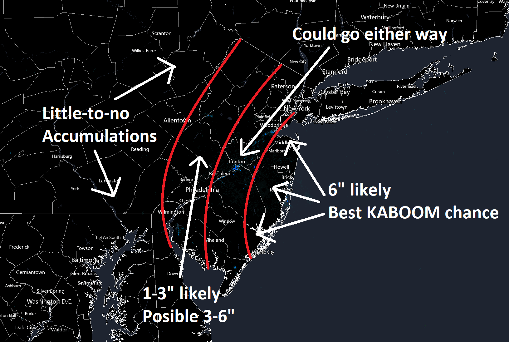
We’re still not to the point of issuing snow maps. There’s a lot that needs to be ironed out regarding the surface output. But if the future surface output aligns with the current upper-level output in the next 24 hours of data, then you’re going to see more of NJ get in on the big snow.
NWNJ and much of WNJ are currently favored for the lowest amount of snow. ENJ, especially SENJ (Monmouth/Ocean/SE Burlington, Atlantic, and Cape May Counties) are currently favored for the highest amount of snow. I think this idea will hold true regardless. The only question is will Philly to the coast (W to E) be a 1-3 inch to 4-8 inch type event…or a 3-6 to 12+ type event. I hope to have this more ironed out for a snow map tomorrow. But for now, consider this very conservative probabilities-based sketch:
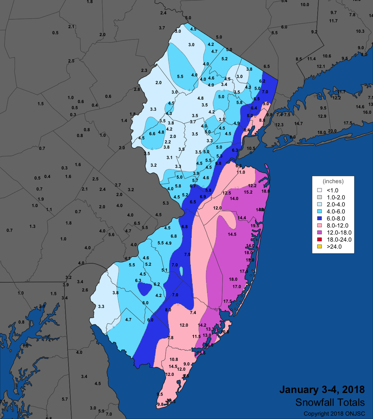
I really like the January 4, 2018 snowstorm as a past analog for this storm to illustrate which parts of NJ should expect the highest and least impact. This, like the boxing day 2011 blizzard are examples of when a coastal storm approaches our offshore region from the S instead of from the SW. This was the total snow output from that storm:
Timing is broad and prolonged. Light snow could break out as early as sunset Friday from the N stream energy decaying (pre-phase) precipitation shield. This would likely favor NNJ over SNJ. Then precipitation will gradually fill into the rest of NJ by midnight or just after (early Sat AM). Snow and wind should then peak Saturday morning into early afternoon. Snow should then taper off from W to E between late Saturday afternoon and Saturday evening.
Coastal regions will no doubt experience higher winds than areas away from the ocean. The wind looks run-of-mill for a strong coastal storm but we’re likely going to be too far W of the storm to experience the heaviest winds of the system. I’m thinking the shore will gust to 40mph at times which is enough to cause power outages. Snow will be stacking on tree branches, adding weight, and the wind will not help. It won’t take much to down tree branches into above-ground power infrsstructure. Coastal flooding could get hairy with 3 high tides of concern (Sat AM, Sat PM, and Sun AM). After a shorter period of initial onshore flow, the winds will become northerly. But given the expected strength and size of the ocean storm, it should push a decent amount of water into ECNJ/SENJ. We’re probably dealing with light-to-moderate coastal flooding at this point.
In English: A snowstorm will impact New Jersey this Friday evening through Saturday. It should arrive after sunset Friday, build up Friday night, peak Saturday morning-afternoon, and taper off by Saturday evening. Right now, ECNJ/SENJ are eyeing the jackpot of heavy snow with NWNJ and much of WNJ eyeing the least amount of snow. See the above rough sketch image. Also see the above analog for reference of how I think this will go down. But ECNJ/SENJ have the best chance to KABOOM. Tomorrow will be the first snow map where expected amounts are given. Tonight and tomorrow’s model runs are probably the most important ones regarding generating a confident forecast in tomorrow’s snow map. Have a great rest of your Wednesday and please be safe! JC
Download the free Weather NJ mobile app on Apple or Android. It’s the easiest way to never miss Weather NJ content. Our premium services go even further above and beyond at the hyper-local level.
Jonathan Carr (JC) is the founder and sole operator of Weather NJ, New Jersey’s largest independent weather reporting agency. Since 2010, Jonathan has provided weather safety discussion and forecasting services for New Jersey and surrounding areas through the web and social media. Originally branded as Severe NJ Weather (before 2014), Weather NJ is proud to bring you accurate and responsible forecast discussion ahead of high-stakes weather scenarios that impact this great garden state of ours. All Weather. All New Jersey.™ Be safe! JC


LOCAL FORECAST | INTERACTIVE RADAR | LATEST NJ WEATHER ALERTS | WEDDING FORECAST| PRIVACY POLICY
© Copyright 2026 Weather NJ LLC. All Rights Reserved.
Some information that can be found on our website is provided by a private weather station and is not an officially recognized station for weather reporting. Though we always strive to achieve accurate reporting for our own use, it is important that you do NOT depend on the data provided here for any purpose.
