

Winter Storm Approaching New Jersey
Discussion: A late-winter deep trough is forming for the weekend. On the front of it, a deepening surface low should bring a heavy rain to heavy snow event to New Jersey tomorrow (Saturday) due to enhanced frontogenic forcing occurring along/over a strong passing thermal gradient. A classic March winter storm with NWNJ targeted for the most amount of snow. Let’s break expectations into categories:
Wind: On the front (warmer) side of the system, winds should ramp up a bit but seem pretty routine for an approaching storm system. This would be from about 4am up until the front passes your location. Winds will increase and become gusty once the front passes over your location. This could be as early as 8am for NWNJ or as late as 2pm for extreme SENJ. But from that point and forward, the surface low will be dropping as it pulls away—reinforcing strong NW flow behind the front. Looks like a sustained 15-25mph with gusts to 45mph for a prolonged time (much of Saturday PM hours into Sunday AM). This could lead to downed trees/branches and related outages. Winds should subside throughout a very cold Sunday.
Temperatures: We’re mild today and overnight tonight. We’ll stay milder (in the 40s) as rain breaks out and falls Saturday morning, but we’ll drop pretty good once the front pushes through. Many places will go from 40-45 and rain to 25-32 and snow between tomorrow morning and tomorrow afternoon. By evening, teens-to-20s from N to S. For this reason, the temp drop deserves it’s own category. Higher snow ratios will allow snow to stack up quicker. It will be challenging for road crews. Rain will initially try to wash away brine and wet conditions will freeze fast with the frontal passage. Saturday night looks very cold after the precipitation clears. With then-existing snowpack and strong NW flow, overnight lows should bottom out in the teens for many. Sunday then looks like a cold fay with temps likely held in the 30s during peak afternoon sun. next week we moderate.
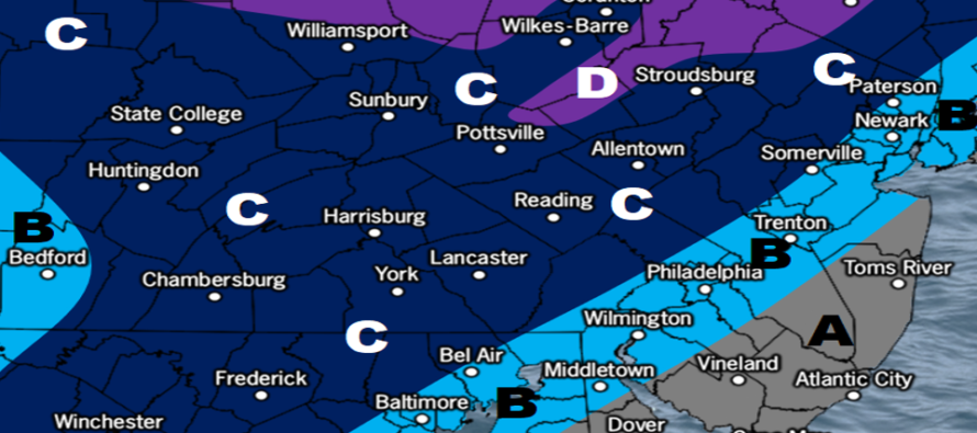
Precipitation/Timing: Most of tonight (Friday night) should be dry and relatively mild. Precip should start between 4-8am tomorrow morning (as snow for extreme NNJ/NWNJ and as rain for everywhere else in NJ). From 8am to early afternoon, a cold front will push through from W/NW to S/SE. Rainfall should intensify before changing over to a period of sleet and then ultimately snow (heavy at times). Most of NJ should snow fairly hard from about noon to 4-5pm. Snow should then taper off from W/NW to E/SE (parallel to the frontal departure) between about 4-6pm. This configuration allows NWNJ to stay in the snow zone the longest and SENJ the shortest amount of time. For these reasons, the following map represents our expectations for snow tomorrow:
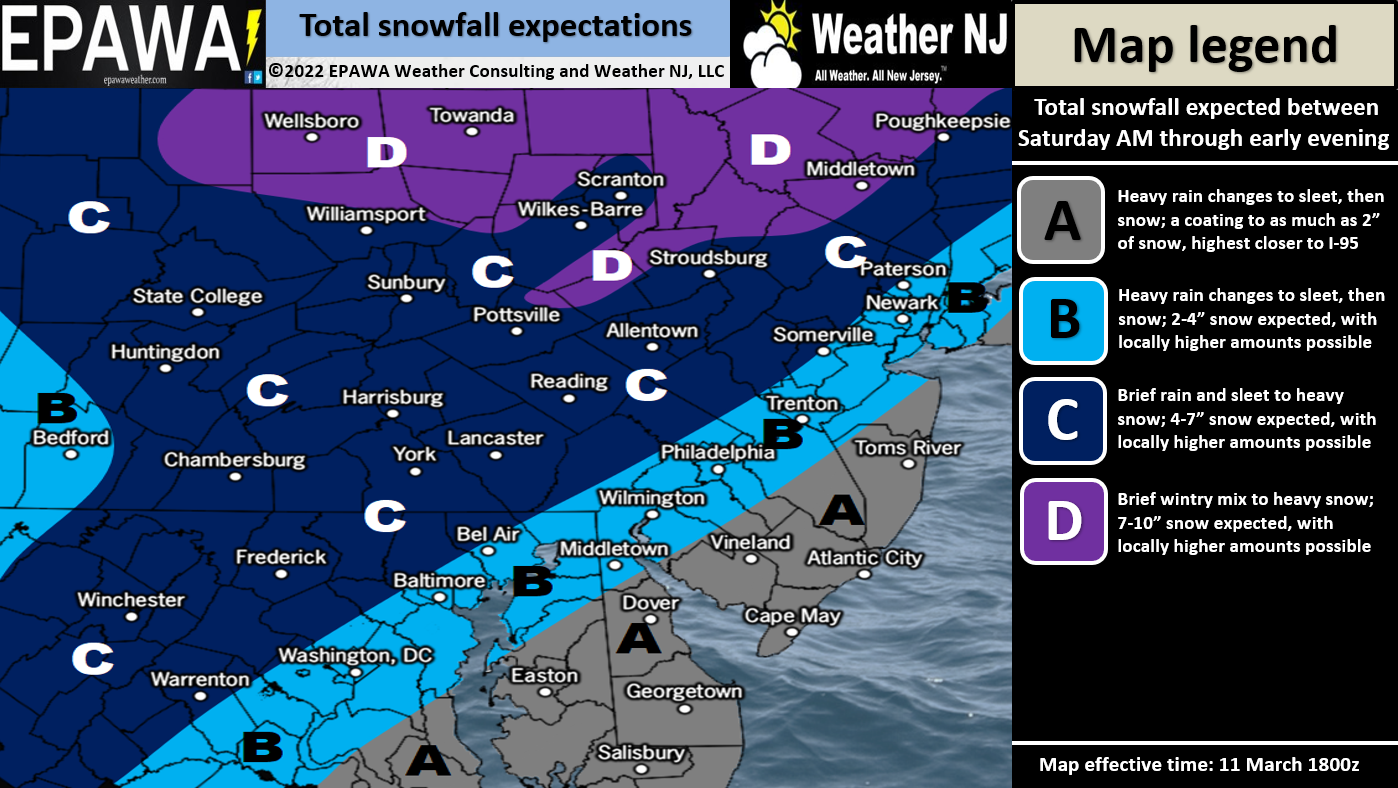
Not that big a deal SE of 95. Mostly rain and wind changing to a coating to a few inches at most and that’s really only for areas closer to 95. Areas like Cape May-Atlantic City probably little-to-no accumulation even after the changeover. This system is targeting areas along and NW of 95. The further NW and higher up you are, the better the chance to reach major snowfall criteria. But for most along and NW of 95, it’s looking like a significant snow storm.
In English: Tomorrow should start mid, rainy, and breezy and end cold, snowy, and gusty. A general storm timing window of 5am to 5pm is anticipated with rain changing to sleet and then snow. Changeover should occur between 9am and 2pm from NWNJ to SENJ. Rain until then and snow after. Winds should crank out of the NW from afternoon into overnight. Live observations begin tonight. Have a great rest of your Friday and please be safe! JC
Jonathan Carr (JC) is the founder and sole operator of Weather NJ, New Jersey’s largest independent weather reporting agency. Since 2010, Jonathan has provided weather safety discussion and forecasting services for New Jersey and surrounding areas through the web and social media. Originally branded as Severe NJ Weather (before 2014), Weather NJ is proud to bring you accurate and responsible forecast discussion ahead of high-stakes weather scenarios that impact this great garden state of ours. All Weather. All New Jersey.™ Be safe! JC


LOCAL FORECAST | INTERACTIVE RADAR | LATEST NJ WEATHER ALERTS | WEDDING FORECAST| PRIVACY POLICY
© Copyright 2026 Weather NJ LLC. All Rights Reserved.
Some information that can be found on our website is provided by a private weather station and is not an officially recognized station for weather reporting. Though we always strive to achieve accurate reporting for our own use, it is important that you do NOT depend on the data provided here for any purpose.
